
Perolniyoc Waterfall Hike | Beautiful Nature & Incredible Inca Ruins

- Created: March 12, 2021 1:00 pm
- Updated: June 9, 2023 4:15 pm
- Distance Instructions
- Travel mode
- walking
- bicycling
- driving
- straight-line


- Distance 4 miles
- Time 1 h 34 min
- Speed 2 mph
- Min altitude 9652 ft
- Peak 11850 ft
- Climb 3350 ft
- Descent 1266 ft


This is a map and basic overview on the Perolniyoc Waterfall hike in Peru's Sacred Valley. This specific map shows the route from the trailhead near the village of Soqma (Socma), up to the stunning waterfall, and finally continues up to the ruins that sit on top of the falls, Raqaypata.
Multiple collectivos stop at the small village of Pachar, so it makes for an ideal place to begin the Perolniyoc Waterfall hike. It's possible to walk all the way from Pachar to the village of Soqma and continue to the falls.
If walking, plan on adding another 3 miles to this itinerary, so the total hike will be just under 7.5 miles. Make sure to stop by the special site of Ñaupa Iglesia, also know as Choquequilla. This free Archaeological Park is fascinating and some say these ancient ruins may contain a "dimensional portal" to another world.
Download the Map | Pachar to Ñaupa Iglesia
After a pit-stop at Ñaupa Iglesia, simply follow the train tracks all the way to the start of the trailhead in Socma. Now, follow along with this Perolniyoc Waterfall hike map.
⁉️ If downloading the map, please verify that the map is correct and follows the waypoints. Oftentimes, there are daily updates to the site, map platforms, and other external issues that may cause a bug in downloading. Be mindful that this map is solely for entertainment purposes. See my full disclosure here. Always hike responsibly and respect the mountains by following a no-trace philosophy, avoid hiking alone, be conscious of the weather and personal limitations, and do not stray from the visible trail
Perolniyoc Waterfall Hike Logistics
- Out & Back Trail
- Difficulty: Moderate, the ascent to the ruins are steep
- Soqma Trailhead - Raqaypata (One-Way Distance): 4.25 miles
- Pachar - Raqaypata (Total One-Way Distance): just under 7.5 miles
- Ascent: Almost 3,350 ft
- Excursion Duration: This hike will take all day, especially if hiking from Pachar, plan accordingly. Those short on time should see about taking a taxi to the trailhead in Soqma.
- Leave early, this will be a long day trip without much shade coverage
- This hike can be complete anytime of the year
- Remember, rainy season the trails can be muddy and slick, but the waterfall will be flowing heavy
- Itinerary Add-Ons:Pachar has a few hiking options to add to this Perolniyoc Waterfall hike
- Easy: Hike to or from Pachar to Ollantaytambo via this Old Inca Road
- Advanced: Continue past the village of Rayon and continue to Laguna Ancascocha | 4 day trekking guide coming soon!
- Day Hiking Essentials
- First-Aid Kit
- Water Filter
- Off-line Perolniyoc Waterfall Hike Map
- Snacks & Picnic
- Trekking Poles for the ascent
Psst... Visiting as a day trip? Urubamba is an ideal city to explore all the highlights of the Sacred Valley
Pachar to Perolniyoc Waterfall Hike Trailhead
Take a collectivo to Pachar, they stop right by the Cerveceria del Valle Sagrado.
Cross the orange bridge and turn right to continue to the tiny hamlet of Pachar. Walk on the main road until you see a reddish bridge. As soon as you cross the bridge, turn left and walk along the railroad tracks. Be mindful, these train tracks are still used frequently.
After a bit, the path will meet up again with the road. Cross the road and continue along the railroad track. Keep your eyes peeled for a blue and white sign that marks the entrance for Ñaupa Iglesia. If you have time, stop and enjoy this special place. Otherwise, continue on the railroad tracks in front of the site.
The beginning of the trailhead of the Perolniyoc Waterfalls hike begins near Soqma and is only a 45 minutes walk from Ñaupa Iglesia.
Pachar - Ñaupa Iglesia - Soqma Trailhead | a little over 3 miles | +/- 2 hours including a quick pitstop at Ñaupa Iglesia
Perolniyoc Waterfall Hike Trailhead to Raqaypata
Now, follow along with this map and continue along the outskirts of Soqma on the hiking trail that runs next to the road. There will be great distant views of Soqma and the dirt path winds past a few homes. You may see those first glimpses of Raqaypata on the hillside.
The path eventually comes to a stream, which make an ideal place to replenish water. Cross the stream and continue on the uphill path to the right. This uphill climb leads to the Perolniyoc Waterfall (Catarata Perolniyoc).
After some photos and a chance to cool off, (there's some shade here), continue on the uphill climb to Raqaypata. There are sign markers, so this part of the Perolniyoc waterfall hike is easy to follow.
The Raqaypata ruins sit on top of the waterfall and are free to explore. The ruins aren't so big, but expect epic views and few, if any people. The highest point of the Raqaypata Archaeological Park sits just under 12,000 ft (3,645 m). Enjoy a picnic and savor those views!
From this site, either continue back down on the same trail back to Pachar, or advanced hikers can continue towards Laguna Ancascocha (proper gear required).
Soqma Trailhead - Raqaypata | 4.25 miles | 3 - 4 hours with stops and exploration
Interested in the Perolniyoc Waterfall Hike
Want to know the all the details on tackling this all day Perolniyoc Waterfall hike? Find useful information, how to reach the trailhead, tips and tricks, more on the alternative routes, and how much it costs to complete the Perolniyoc Waterfall hike. Follow along with this complementing blog post:
The Complete Guide to the Perolniyoc Waterfall Hike
Adventures Near Perolniyoc Waterfall Hike
- Ñaupa Iglesia | En-route to the Perolniyoc Waterfall Hike | "Dimensional Portal"
- Pachar to Ollantaytambo | Follow an Old Inca Road
- Pumamarca | Ollantaytambo | interesting fortress shaped like a Puma
- Inti Punku | Ollantaytambo | incredible Sun Gate that follows along an Old Inca Quarry Road
- Laguna Ancascocha | Multi-Day Trek | Off-the-beaten-path trek through the Andes (coming soon)
- Saywa | Urubamba | Peculiar Hilltop Ruins with panoramic views of Sacred Valley & mountains
- Laguna Juchuycocha | Urubamba | Stunning alpine lake that sits at 15,200 feet with awesome views of Chicon
- Kinsa Cocha | Pisac | 3 Lakes in the Andes Mountains
More Cusco & Sacred Valley Resources
- The Ultimate Cusco and Sacred Valley Itinerary for One Week
- Browse Five Different & Unique Cusco Itineraries
- 23 Spectacular Things to Do in Cusco
- Where to Eat in Cusco
- All the Awesome Things to Do in the Sacred Valley
- The Only Guide You Need for Ollantaytambo Peru
- 35+ Peru Inca Sites You Have to Visit
- Unique & Famous Peru Landmarks to See



1. Pachar
Collectivos drop here in the village of Pachar
2. Ñaupa Iglesia
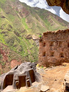
Add-on this "dimensional portal"
3. Begin Trailhead for Perolniyoc
Begin Perolniyoc Waterfalls Hike
4. Perolniyoc Waterfall
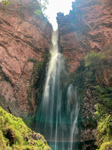
"Cataratas de Perolniyoc"
5. Official Signage for Raqaypata
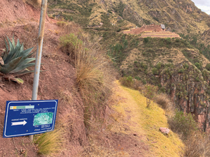
Continue for Inca Site
6. Raqraypata Archaeological Park
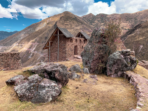
Inca Ruins on top of the Perolniyoc Waterfall