San Prudencio Monastery Ruins Hike Map

- Created: June 11, 2024 3:00 pm
- Updated: June 15, 2024 2:14 pm
- Distance Instructions
- Travel mode
- walking
- bicycling
- driving
- straight-line


- Distance 4839 ft
- Time 22 min
- Speed 2 mph
- Min altitude 2310 ft
- Peak 2949 ft
- Climb 121 ft
- Descent 673 ft


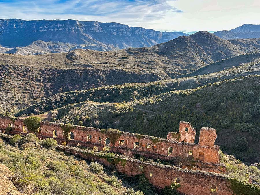
This is a quick overview of how to hike to the Monasterio de San Prudencio (San Prudencio Monastery Ruins) in the La Rioja region of Spain
The once-grand monastery is found on the rugged cliffside of Peña Aguda and can be reached from a few different locations. This map focuses on the steep and narrow route from Clavijo.
The trail is fairly straightforward and is an out-and-back trail. Be mindful that you will be descending to the ruins and then on the hike back it's a fairly steep ascent to return to the trailhead. I follow this hiking path as an out-and-back trail, but numerous routes on different map applications show a loop trail around Monte Laturce.
Stay on the paths and hike at your OWN RISK near the Monastery Ruins. Do not wander inside the ruins too much, especially where the ground is weak and could easily cave in on itself.
Here is my San Prudencio Monastery ruins hike map from Clavijo.
⁉️ If downloading the San Prudencio ruins hike map, please verify that the map is correct and follows the waypoints. Oftentimes, there are daily updates to the site, map platforms, and other external issues that may cause a bug in downloading. Be mindful that this map is solely for entertainment purposes. See my full disclosure here. Always hike responsibly and respect the mountains by following a no-trace philosophy, avoid hiking alone, be conscious of the weather and personal limitations, and do not stray from the visible trail
Clavijo to San Prudencio Ruins Out & Back Hike Map Logistics
- Out & Back Trail
- This map follows the out-and-back trail from Clavijo
- Official Trail Markers: The route has no trail markers as it is only one path to the ruins. There is a signboard to mark the official trailhead with a bench and garbage can.
- Difficulty: Moderate, it's fairly steep and narrow
- The trail is sometimes stoney with loose rocks. Always be mindful of trail closures and respect them.
- Distance Clavijo to San Prudencio Ruins One-Way: Just under 1 Mile (1.5 Km)
- Distance Out & Back: 1.85 Miles(3 Km)
- Excursion Duration: +/ - 1 hour, depending on how much you wander the site
- The hike to the Monastery took me about 20 minutes with the return taking longer due to the ascent (30 minutes)
- Hiking Day Pack Essentials for the Ruins of San Prudencio Monastery
- First-Aid Kit
- Small Day Hiking Backpack
- Water in a Reusable Water Bottle
- Trekking Poles if you love them
- Hiking Boots or trail runners
- An offline map from some source
- Extra Battery Pack for electric devices
Remember that the ruins are just that and are in a state of despair. The trail is quite rugged and won't be for everyone. It's also important to note that the ruins themselves are deteriorating. Always use caution and be careful with your footing. I saw sections of ground inside the ruins that looked like they were ready to collapse. There are parts of the monastery that are underground and it is dangerous to walk inside the ruins.
Once at the ruins, there are no services. This is an isolated hike to see the beauty of the Leza River valley and abandoned monastery that is being reclaimed by the Earth. Use caution and common sense near the ruins.
San Prudencio Monastery Ruins Hike Map Out & Back Trail from Clavijo
This is a basic map for hiking to the ruins of San Prudencio Monastery from Clavijo. For the complete hiking guide, photo inspiration, and more on the legends, read the complementing blog post:
Hike to the Ruins of San Prudencio Monastery
More La Rioja Guides
- How to Visit San Millan de Cogolla and the Yuso & Suso Monasteries
- Termas de Arnedillo Hot Springs in the La Rioja Region
- The Best Things to Do in Arnedillo A Hidden Gem in La Rioja Spain


1. Clavijo Main Church Plaza

Point of reference looking at Clavijo Castle
2. Bike & Foot Passage Gate

Gate to block cars to reach San Prudencio Ruins Trailhead
3. Clavijo Trailhead

Official trailhead to reach Ruins of San Prudencio Ruins
4. Viewpoint

5. San Prudencio Ruins

6. Front of Ruins

7. Real Basílica de Santiago

Hermitage chapel with a hike to peak of Monte Laturce
This is a quick overview of how to hike to the Monasterio de San Prudencio (San Prudencio Monastery Ruins) in the La Rioja region of Spain
The once-grand monastery is found on the rugged cliffside of Peña Aguda and can be reached from a few different locations. This map focuses on the steep and narrow route from Clavijo.
The trail is fairly straightforward and is an out-and-back trail. Be mindful that you will be descending to the ruins and then on the hike back it’s a fairly steep ascent to return to the trailhead. I follow this hiking path as an out-and-back trail, but numerous routes on different map applications show a loop trail around Monte Laturce.
Stay on the paths and hike at your OWN RISK near the Monastery Ruins. Do not wander inside the ruins too much, especially where the ground is weak and could easily cave in on itself.
Here is my San Prudencio Monastery ruins hike map from Clavijo.
⁉️ If downloading the San Prudencio ruins hike map, please verify that the map is correct and follows the waypoints. Oftentimes, there are daily updates to the site, map platforms, and other external issues that may cause a bug in downloading. Be mindful that this map is solely for entertainment purposes. See my full disclosure here. Always hike responsibly and respect the mountains by following a no-trace philosophy, avoid hiking alone, be conscious of the weather and personal limitations, and do not stray from the visible trail
Clavijo to San Prudencio Ruins Out & Back Hike Map Logistics
- Out & Back Trail
- This map follows the out-and-back trail from Clavijo
- Official Trail Markers: The route has no trail markers as it is only one path to the ruins. There is a signboard to mark the official trailhead with a bench and garbage can.
- Difficulty: Moderate, it’s fairly steep and narrow
- The trail is sometimes stoney with loose rocks. Always be mindful of trail closures and respect them.
- Distance Clavijo to San Prudencio Ruins One-Way: Just under 1 Mile (1.5 Km)
- Distance Out & Back: 1.85 Miles(3 Km)
- Excursion Duration: +/ – 1 hour, depending on how much you wander the site
- The hike to the Monastery took me about 20 minutes with the return taking longer due to the ascent (30 minutes)
- Hiking Day Pack Essentials for the Ruins of San Prudencio Monastery
- First-Aid Kit
- Small Day Hiking Backpack
- Water in a Reusable Water Bottle
- Trekking Poles if you love them
- Hiking Boots or trail runners
- An offline map from some source
- Extra Battery Pack for electric devices
Remember that the ruins are just that and are in a state of despair. The trail is quite rugged and won’t be for everyone. It’s also important to note that the ruins themselves are deteriorating. Always use caution and be careful with your footing. I saw sections of ground inside the ruins that looked like they were ready to collapse. There are parts of the monastery that are underground and it is dangerous to walk inside the ruins.
➯ Hey… don’t forget your Travel Insurance! I love SafetyWing
Once at the ruins, there are no services. This is an isolated hike to see the beauty of the Leza River valley and abandoned monastery that is being reclaimed by the Earth. Use caution and common sense near the ruins.
San Prudencio Monastery Ruins Hike Map Out & Back Trail from Clavijo
This is a basic map for hiking to the ruins of San Prudencio Monastery from Clavijo. For the complete hiking guide, photo inspiration, and more on the legends, read the complementing blog post:
Hike to the Ruins of San Prudencio Monastery
More La Rioja Guides
- How to Visit San Millan de Cogolla and the Yuso & Suso Monasteries
- Termas de Arnedillo Hot Springs in the La Rioja Region
- The Best Things to Do in Arnedillo A Hidden Gem in La Rioja Spain
Pack This Post for Later! Pin It!
Disclaimer: There’s a chance this post contains affiliate links, and I receive a small (but grateful) portion of the sale. There’s no extra cost to you, and I only promote things that I use and love.
Disclosure: This is part of my Hikes & Adventures series, which means these treks can be strenuous and challenging. These are my experiences and I am not an expert. Please have all the proper equipment, verify the weather conditions, use professional resources, do your own research, be mindful of constantly changing trail conditions, and take into consideration your own physical abilities and/or limitations. These guides are for entertainment purposes only. Please see my full disclosure for more information here.