
3 Day Quilotoa Loop Map | Hiking From Sigchos to Picturesque Quilotoa Lake

- Created: March 23, 2022 1:00 pm
- Updated: September 16, 2023 5:07 pm
- Distance Instructions
- Travel mode
- walking
- bicycling
- driving
- straight-line


- Distance 24 miles
- Time 72 h 0 min
- Speed 2 mph
- Min altitude 8323 ft
- Peak 12661 ft
- Climb 8038 ft
- Descent 4774 ft


This is a basic overview of just one of the many diverse routes for hiking the Quilotoa Loop Ecuador. This Quilotoa Loop map follows the "standard route" from Sigchos to the famous crater Quilotoa Lake. Hikers that wish to hike the "reverse route" should start from Laguna Quilotoa and finish in Sigchos.
This basic overview includes how to reach the trailhead in Sigchos from Latacunga, helpful tips, a basic packing list, and other things to see and do along one of Ecuador's most popular treks. Follow along and download this Quilotoa Loop map to your phone.
Here's the 3-day standard trekking itinerary and Quilotoa Loop Map from Sigchos to Laguna Quilotoa.
⁉️ If downloading the map, please verify that the map is correct and follows the waypoints. Oftentimes, there are daily updates to the site, map platforms, and other external issues that may cause a bug in downloading. Be mindful that this map is solely for entertainment purposes. See my full disclosure here. Always hike responsibly and respect the mountains by following a no-trace philosophy, avoid hiking alone, be conscious of the weather and personal limitations, and do not stray from the visible trail
Standard Quilotoa Loop Trek Sighchos to Laguna Quilotoa in 3 Days
The hostel La Posada Hostel del Viajero is a no-frills hostel with private bathrooms that stows luggage for free for hikers. The owner is a former guide, so he is incredibly helpful and speaks perfect English. Bonus, during the busy season, he offers to book guesthouses along the route.
- Point-to-Point Trail
- 3 Day Trek
- This Quilotoa Loop map starts in Sigchos village and ends in Quilotoa village
- Mileage: +/- 24 miles | There are different trail options along the route
- Trail Markers: The trail is fairly well marked with wooden red and yellow signboards along the route. Sometimes the paths aren't marked, so an offline Quilotoa Loop map is essential. Maps.me has all of the trail options
- No camping gear is necessary.
- There are guesthouses in each village that always provide a nighty paper Quilotoa Loop Map, dinner, and breakfast. Average cost is $15 - $20 per night
Schedule | Quilotoa Loop Trek | 3 Days
- Day 1 | Sigchos to Isinlivi | 7.75 miles
- Day 2 | Isinlivi to Chugchilán | 8 miles
- Day 3 | Chugchilan to Quilotoa via the "Adventure Route" | 8.4 miles
Day 1 | Sighchos to Isinlivi
Most hikers will depart from Latacunga early in the morning. There's an excellent local market to grab some last-minute snacks for the trek. The bus to Sigchos from Latacunga takes close to two hours, so aim to take a bus before 10:00 to allow proper time for hiking.
🚌 Latacunga to Sigchos Bus Logistics | Buses depart from: Latacunga Terminal Terrestre | Bus Company: Reina de Sigchos | Current Morning Departure Times: 5:00, 6:00, 8:00, 9:30 | Average Cost: $2.65 | Duration: 2 hours
In Sigchos, walk past the main plaza towards the outskirts of town where the Saturday Animal Market takes place. Hikers should take the road to the right and follow the signs to Isinlivi.
Make sure to check in with an offline Quilotoa Loop map, since there are small paths that lead to private property. I took a few of those trails, but it's easy to realize when you're off-path.
The first day of the Quilotoa trek is pretty casual. Many sections of the trail are a descent. There's an option to take a quick detour to the Cascade Gualligua, a great place to cool off on a hot afternoon. Cross the Toachi River via a concrete bridge and start the uphill trek to Isinlivi.
The picturesque village of Isinliví has a few nearby mirador trails, woodwork artisans, and a small church.
- Distance: 7.75 miles
- Duration: 3.5 - 5 hours, dependent on weather, breaks, and fitness level
- Popular Guesthouses:
- Llullu Llama Mountain Lodge | Famous mountain lodge that boasts a hot tub
- Hostal Taita Cristobal | Family run-guest house with green space and on-site llamas
Day 2 | Isinlivi to Chugchilan
After a hearty breakfast begin on the trail to Chugchilan. Shortly after you leave, there will be a bridge, however, don't cross it. Rather, take the "sendero," or small path to the right. This scenic trail can be muddy, especially during the rainy season but twists through the beautiful canyon.
Walk along the beautiful Toachi River. There will be a wooden bridge made from a tree. Cross it to reach a gravel path. The path leads to the small hamlet of Itualo. Walk past the church and look to the right. There will be an uphill grass path near a small shack. Begin the ascent up to the small community of Chinaló.
In Chinaló, stop by the mirador that offers incredible views of the Toachi Canyon. At the mirador, find a covered awning, a bench, and a garbage drop. The nearby community sells fresh fruit and some artisan goods. The viewpoint is fantastic on a clear day!
Not too long after Chinalo, you will reach a paved road, which leads to Chugchilan.
- Distance: 8 miles
- Duration: +/- 4 - 5 hours
- Popular Guesthouses:
- Hostal Cloud Forest | Known for its hearty home-cooked food, central location & for marking the Quilotoa Loop with signboards
- Hostal el Vaquero | Located outside of the village with lots of green space and a sauna
- Black Sheep Inn | Luxury mountain huts with award-winning vegetarian meals, shared rooms for $20
☛ Travel Tip | Some people often opt to spend an extra night in Chugchilán to tour the local cheese factory of Quesería San Miguelito or explore nearby places via day hikes, including Quilotoa Lake. There are a few bars, including a tap house that pours microbrews from The Golden Prague in Cuenca
Day 3 | Chugchilan to Quilotoa Loop
On the final day, there are two paths to choose from. The standard route that most hikers take passes through La Moya Baja and La Moya Alta. Alternatively, there's a quicker, but more steep "adventure route" that passes by the outskirts of the Guayama San Pedro. Check in the hostels before departure as sometimes the adventure route can be closed due to mudslides.
This Quilotoa Loop map follows the adventure route.
At the signboard after Sigue, turn left to follow along the grassy trail. Cross the the Sigue River via a rickety wooden bridge. There are plenty of markers for Quilotoa Lake. There is another makeshift bridge further up.
⁉️ Update The second bridge is susceptible to being destroyed and unusable due to mud and rockslides. This bridge has been lost to a rockslide as of the summer of 2023. From a reader, they suggest following the longer road route on maps.me to Guyama Grande community. There is a trail to the right that ascends to the lake. This path merges with the Crater Lake viewpoint and takes a little over 4 hours.
There's an excellent viewpoint of the canyon below before arriving in Guayama San Pedro. Walk along the outskirts of town and follow the gravel path up the to first viewpoint of the Laguna Quilotoa.
Afterward, there are two paths a lower loop trail and a higher Quilotoa loop trail.
This Quilotoa Loop map ends at the final viewpoint in Quilotoa across from Hostería Chukirawa.
. There is an entrance fee to access the Quilotoa Community.
Quilotoa Community Entrance Fee: $2 USD, pay it upon exit or pay an authorized seller... they will give you a ticket
- Distance: 8.4 miles
- Duration: +/- 4.5 hours - 6 hours
What Next?
There are lots of little restaurants and artisan shops in Quilotoa. Some opt to stay here a night and hike down to the actual crater lake to rent a boat. Others opt to walk around the entire crater the following day. For me, I much preferred the solitude of the journey to Quilotoa Lake. The guesthouses in Quilotoa village are usually more expensive in comparison to guesthouses along the route.
Popular Guesthouses in Quilotoa Village
Return to Latacunga
Alternatively, you can hop on a bus back to Latacunga. There are direct buses that depart frequently. Catch them outside of town, near Samay Kirutoa Lodge. Be mindful that the buses don't start here, so oftentimes they are late or early. It's best to simply wait here.
🚌 Quilotoa to Latacunga Buses | Average Fare: $2.50 | Duration: 2.5 hours | Current Departure Schedule: 5:30, 6:30, 7:00, 8:45, 10:45, 12:15, 13:45, 14:45, 15:30 16:15, 17:00, 17:30
Travelers who wish to walk another day can hike the village of Zumbahua where there are frequent buses back to Latacunga.
3 Day Quilotoa Loop Map | Sigchos to Quilotoa Lake
Want all the logistics that accompany this 3-Day Quilotoa Loop Map? Get more detailed information, useful tips and tricks, photo inspiration, and how much this popular multi-day trek in Ecuador costs. Follow along with this complementing blog post:
Detailed 3 Day Quilotoa Trek Hiking Guide
More Ecuador Hikes
- 3 Day Ecuador Inca Trail Trek Achupallas to Ingapirca
- Devil's Nose Hike from Alausi Ecuador
- Cajas National Park Hiking Guide
- Underrated Laguna Llaviucu Loop Trail
- El Chorro Waterfall in Giron Ecuador
Ecuador Travel Guides
- Awesome Things to Do in Cuenca Ecuador
- 10+ Spectacular Day Trips from Cuenca Ecuador
- Visit Saraguro Ecuador
- 20+ Charming South American Villages in the Andes Mountains

1. Trailhead Quilotoa Loop
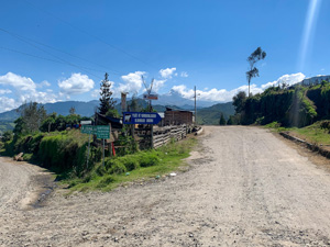
Start the Trailhead near the Sigchos Animal Market, take the road to the right
2. Chapel Nuestra Senora del Cisne
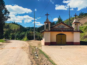
Small Church
3. Grass Path
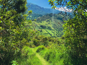
Merge off the dirt road and take the small grass path
4. Cascade Gualligua
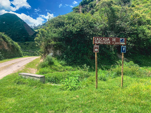
Optional short trail to Gualligua Waterfall
5. Cement Bridge Crossing
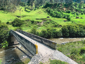
Rio Toachi Bridge Crossing
6. Isinlivi Village
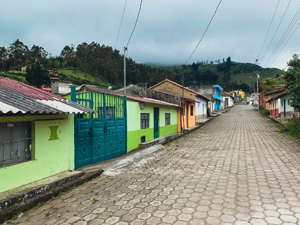
Isinliví hamlet | Elevation: 9,655 ft. (2,943 m) | Sleep here night 1
7. Path Before Bridge
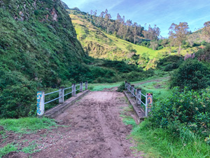
Take the small "sendero" to the right before this bridge
8. Tree Bridge
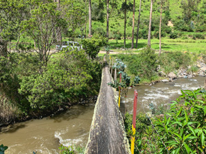
River crossing via a tree bridge
9. Itualo

Small hamlet | Walk through village and turn right at the small shack to begin ascent to mirador
10. Mirador Cañon del Toachi

Viewpoint with covered seating, garbage-drop, & community that sells snacks, fresh fruit, and artisan goods
11. Chugchilan Village

Chugchilán village | Elevation: 10,500 ft. (3,200 m) | Sleep here night 2
12. Wooden Bridge
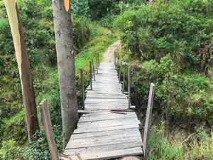
Bridge crossing on "Adventure Route"
The second bridge has been destroyed from a rockslide
13. Guayama San Pedro
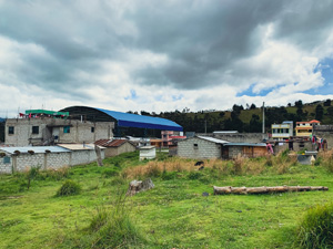
Small hamlet before Quilotoa
14. First Mirador Quilotoa Lake

First Mirador of Laguna Quilotoa | Small bar cafe with observation deck | Continue on high walking path
15. Quilotoa Village Mirador

Quilotoa village | Elevation: 12,680 ft. (3,865 m) | Village Admission: $2 USD | Sleep here night 3, or return to Latacunga via bus