The Breathtaking Quilotoa Loop in 3 Days | One of the Best Hikes in Ecuador
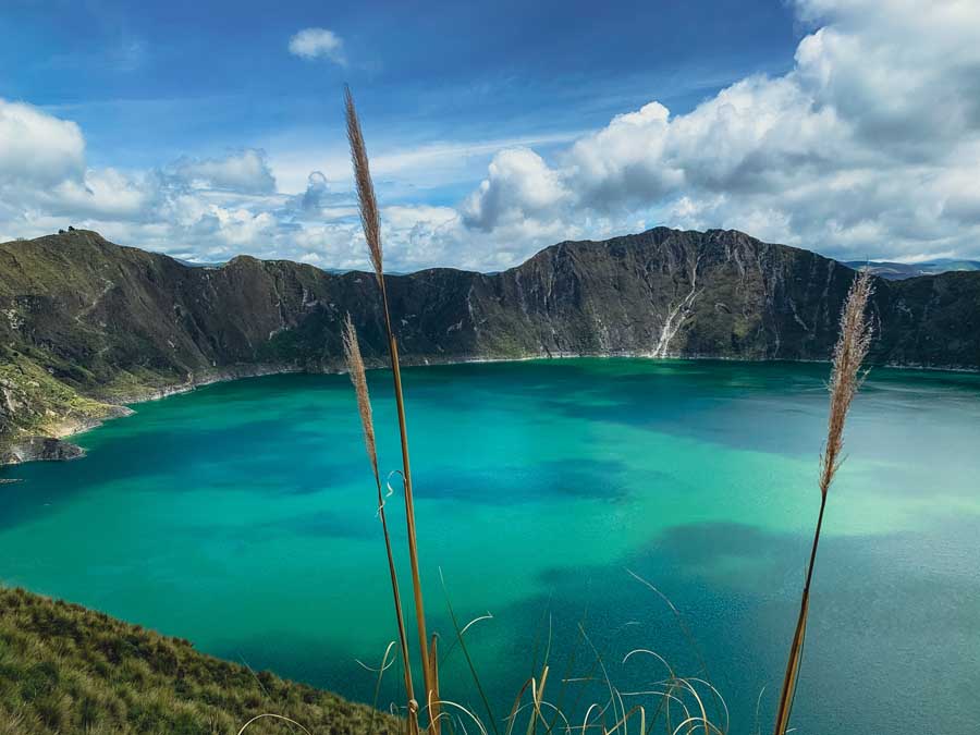
While backpacking through Ecuador, you will hear travelers talking about the popular multi-day trek filled with beauty and culture, the Quilotoa Loop. The Laguna de Quilotoa is a striking crater lake found in Ecuador’s Cotopaxi Province in the famed “Avenues of Volcanoes.” This incredible stretch of land between Quito and Cuenca is the heart of the Ecuadorian Highlands and includes a shockingly vast quantity of both active and dormant volcanoes.
The Quilotoa loop trek offers a chance to appreciate the Andes Mountains in all of their majestic glory.
While many visitors opt to visit Quilotoa Lake as a day trip from Quito, those seeking an intimate cultural experience in spectacular nature will love hiking the Quilotoa Loop. The multi-day hike includes overnight stops in small communities and twists through the Los Illinizas Nature Reserve in the heart of the mystical Andes Mountains.
The Quilotoa Loop trek is adventurous and is often praised as one of the best treks in Ecuador.
This complete Quilotoa Loop trekking guide follows the “standard route.” This is the typical route that moves from north to south, starting from the village of Sigchos and ending at the stunning Quilotoa Crater Lake.
Below, find a Quilotoa hike map, helpful travel tips, a day-by-day Quilotoa loop trekking itinerary in 3 days, and how much to budget for the Quilotoa Loop 3 day hike.
Table of Contents
Disclosure: This is part of my Hikes & Adventures series, which means these treks can be strenuous and challenging. These are my experiences and I am not an expert. Please have all the proper equipment, verify the weather conditions, use professional resources, do your own research, be mindful of constantly changing trail conditions, and take into consideration your own physical abilities and/or limitations. These guides are for entertainment purposes only. Please see my full disclosure for more information here.
- Quilotoa Loop Map & Trek Logistics
- What to Pack for the Quilotoa Loop Trek
- Useful Tips for the Quilotoa Loop Trek
- Detailed Schedule | Hiking Quilotoa Loop 3 Days
- Total Cost of Quilotoa Loop 3 Day Hike
- Where to Next After Laguna Quilotoa?
- Review | The Complete Guide to Hiking Quilotoa Loop in 3 Days
Quilotoa Loop Map & Trekking Logistics
Here’s my personal Quilotoa Loop 3 day hike map and daily trekking itinerary.


Daily Schedule | Quilotoa Loop 3 Day Trek
This schedule follows the standard Quilotoa trekking route of Sigchos to Quilotoa Crater Lake in 3 days.
- Day 1 | Sigchos to Isinlivi | 7.75 miles
- Day 2 | Isinlivi to Chugchilán | 8 miles
- Day 3 | Chugchilan to Quilotoa via the “Adventure Route” | 8.4 miles
Quilotoa Loop 3 Day Trekking Logistics

- Point-to-Point Trail
- 3 Day Trek
- This Quilotoa Loop map starts in Sigchos village and ends in Quilotoa village
- Mileage: +/- 24 miles | There are different trail options along the route
- Difficulty: Moderate
- Trail Markers: The trail is fairly well marked with wooden red and yellow signboards along the route. Sometimes the paths aren’t marked, so an offline Quilotoa Loop map is essential. Maps.me has all of the trail options for hiking Quilotoa Loop.
- No camping gear is necessary for trekking the Quilotoa Loop
- Be mindful of the altitude
- Sigchos sits at an elevation of 9,437 ft. (2,876 m) and steadily climbs up to Quilotoa Village at an elevation of 12,680 ft. (3,865 m).
- With ups and downs along the trail, I tracked a total ascent of around 8,038 ft (2450 m) along the Quilotoa trek.
➯ Hey… don’t forget your Travel Insurance! I love SafetyWing
What to Pack for the Quilotoa Loop Trek
The truth is that you don’t need too much trekking gear for the Quilotoa Loop hike. While there are camping options, I think part of the charm of this multi-day trek is staying at the local guesthouses along the way.
The guesthouses on the Quilotoa Loop provide everything you need from sheets and towels, to trail updates, paper Quilotoa Loop maps, and delicious meals. Many accommodations provide wooden stoves in the room for chilly nights.

The lighter your backpack, the better. Most Quilotoa Loop guesthouses average $15 – $20 per night per person and include meals (breakfast and dinner).
That being said, you’ll need some hiking essentials, like good hiking boots with ankle support. It’s even better if the hiking boots are water-resistant. I swear by always wearing Merino Wool socks with hiking boots.
The trails can be muddy and steep, so hiking poles can provide some relief. Any backpack around 36 L is ideal. I carried my trusty Osprey Kyte 36L, which has been recently changed to a 38 L backpack now.
I always carry a refillable Water Bottle to cut down on unnecessary plastic waste. The guesthouses provide fresh drinking water, but if you drink a lot you may want to bring a water filter. For me, I never used the water filter when hiking the Quilotoa Loop trek, and sufficed with refills at the guesthouse.
Wear layered clothing, preferably long sleeves and hiking pants for sun protection and from bushy overgrowth. I brought a baseball cap and wore a Buff to help protect me from the strong Andes sun.
Natural Sunscreen and Bug Spray are also useful.
All you’ll need are small toiletries for showering, as towels are typically provided by the guesthouses. You may wish to bring a swimsuit, especially if you planning on staying in guesthouses with hot tubs and saunas. Yes, there are little luxuries along the Quilotoa Loop trek!
A lightweight rain jacket is nice. At night make sure to have warm clothing (keep them dry) for night. The nights are chilly and I utilized a wool hat and mittens.
I never leave for any trek without a well-stocked first aid kit and at least one emergency blanket.
I did use an offline map quite a bit, actually more than I thought. Make sure to carry a power bank and all the correct chargers. Pick up the paper Quilotoa Loop Map each night from the guesthouse.
If you have space in your bag it’s best to bring something to help pass the time at night like a journal or a book or Kindle, and maybe even a tablet, and all the essential chargers.
Useful Tips for the Quilotoa Loop Trek

Here’s more useful information when prepping for hiking the Quilotoa Loop trek.
Skip to | Which Quilotoa Loop Route? | When to Hike Quilotoa Loop & Altitude | Quilotoa Loop Tour vs. Independent Hike | Safety Tips for Quilotoa Loop
Most Hikers Start the Quilotoa Trek in Latacunga Ecuador
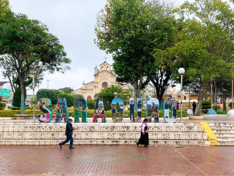
Latacunga is a fairly large city and hub in the Ecuador Highlands. This is the most common starting point for those looking to hike the Quilotoa Loop. While not exactly a picturesque city, Latacunga does have a large local market, a busy main bus terminal, and is a central hub for Ecuador’s Volcano Alley.
There are also plenty of restaurants, artisan shops, and places to stock up on last-minute supplies for the trek. At night, locals enjoy strolling the large plaza that is filled with street food vendors and activities.
You will have to carry enough cash for the entire trek since there are no ATMs on the Quilotoa Loop trek. Latacunga is the last place to stock up on cash for the next 3 days.
How to Get to Latacunga Ecuador
Latacunga is around 2 hours from Ecuador’s capital city of Quito. Most travelers move south from Quito’s Quitumbe Terminal to explore the nearby reserves, including Cotopaxi National Park.
🚌 Quito to Latacunga Buses | Buses Depart: frequently from Terminal Terrestre Quitumbe | Average Bus Fare: $3 USD | Duration: 2 hours | Depending on what bus company, you may be dropped on the main highway where you will have to bargain with taxi’s for a ride into town (I couldn’t get lower than $4 for the 2-minute ride)
Alternatively, from the South, most travelers will come from Riobamba, or as far away as Cuenca. Be mindful that the bus ride from Cuenca to Latacunga takes at least 8 hours, so a night bus may be optimal.
🚌 Riobamba to Latacunga Ecuador | Bus Company: Chimborazo | Average One-Way ticket: $4 | Duration: 2 hours
Where to Sleep in Latacunga Ecuador
The hostel La Posada Hostel del Viajero is a no-frills hostel with private or shared rooms. All rooms have private bathrooms and they stow extra luggage for free for hikers.
The owner, Victor, is a former guide and is happy to answer any questions about hiking the Quilotoa loop and even offers to reserve guesthouses along the route for free. Victor speaks excellent English and has tons of useful information for the entire Cotopaxi region and surrounding hikes.
Two more popular hostels in Latacunga for backpackers are Hostal Central which recently stows bags for free and Hostal Café Tiana which stows luggage for $1 a day.
➜ Find the best Latacunga hotels, hostels, and guesthouses here
Hiking Quilotoa Loop Standard Route vs. Reverse Route

There are multiple ways to hike to Ecuador’s top attraction, but most plan for 3 days. The standard trek route is from North to South and begins in the village of Sigchos and ends in Quilotoa Village.
Alternatively, the “reverse route” is hiked from the Quilotoa Crater Lake to Sigchos.
Some say that the reverse route is easier since it starts at the Quilotoa Crater Lake which has a staggering elevation of 12,841 ft. The trail ends in Sigchos which has a significantly lower elevation of 9,265 ft. However, the trail ascents and descents day by day, so there really isn’t a very notable difference.
The standard route finishes at the Quilotoa Crater, so makes for a superb finale.
Whichever route way you choose, you will enjoy the Quilotoa loop trek.
When to Hike the Quilotoa Loop & Altitude Tips

The Quilotoa Loop can be hiked any time of the year; however, keep in mind that the Ecuador Highlands have two very distinctive seasons, dry and rainy. In general, the dry season is from April to October, while the rainy season is from November until March.
However, the Ecuador Highlands can have less rain in the months of December and January.
Remember, at these high altitudes, the weather is wild, volatile, and can change in an instant.
During the dry season, there is less rain, but the nights are cooler than the rainy season. With the rainy season comes the vivid green coloring, but also muddy trails and higher possibilities of mudslides and rock slides.
The hiking paths along the Quilotoa Loop are a mixture of gravel roads, dirt, and grass paths. Most mornings start out clear, but since it’s in a cloud forest, the clouds almost always roll in around noon.
💬 Personal Experience | I hiked the Quilotoa Loop in January and had beautiful weather up until 14:00 every day. Some days it was just cloudy in the afternoons, while other days there were brief and light rain showers.
The lowest elevation of the Quilotoa trek is around 8,300 ft, so it’s best to be properly acclimated to the elevation. If you’re already in Ecuador, that should be no problem, unless coming directly from the coast or the Galapagos Islands.
Drinking coca leaf tea or guayusa tea can help alleviate altitude sickness.
For reference, here are the Quilotoa Loop elevations of popular sleeping villages along the trek.
Isinlivi Elevation: 9,655 ft (2,943 m) | Chugchilan Elevation: 10,500 ft. (3,200 m) | Quilotoa Elevation (village): 12,680 ft. (3,865 m)
Quilotoa Loop Tour vs. Independent Hiking Quilotoa Loop

There are many guided Quilotoa Loop tours, yet many visitors opt to hike the loop on their own.
This is one of the most popular treks in Ecuador and many hikers walk the trails daily. Since most sleep in guesthouses along the route, it’s easy to talk with fellow hikers, get up-to-date trail information, and find new hiking buddies along the way.
Each guesthouse also provides a hand-drawn map plus all of the trail options are clearly marked on Maps.me. There are signboards along the way. However, it’s still possible to deviate from the trail. (As you can see I had a few short missteps).
If you have basic hiking skills, can follow an offline hiking map, and aren’t worried about time, you will have no problems hiking the Quilotoa Loop without a tour. On the contrary, local guides are easy to find in the villages or can be arranged in Latacunga. Always do what feels best for you.
Quilotoa Loop Tours
If looking to organize a trekking Quilotoa Loop Tour before arrival, there are some 3-day treks from Quito and condensed 2-day treks.
The Quilotoa Lake can be visited without a trek as a full-day trip from Quito, too.
Safety Tips for Quilotoa Loop Ecuador

The Quilotoa Loop hike is generally safe.
Guesthouses will steer you away from any hazards like rocks or mudslides that happen along the trail. The communities are warm and inviting and have their own set of laws, so I never felt unsafe walking the loop alone. With that being said, the Andes Mountains are unpredictable and should always be respected and never underestimated.
Sometimes the dogs can be territorial and seem aggressive. If you reach down to “grab a stone” they usually run away. Some people prefer carrying hiking poles or a stick just to help shield themselves from hostile dogs.
Detailed Schedule | Hiking Quilotoa Loop 3 Days

This a day-by-day breakdown for hiking the Quilotoa Loop in 3 days via the north-to-south route, Sigchos to Quilotoa Village.
Skip to | Quilotoa Loop Hike Day 2 | Quilotoa Loop Hike Day 3
Day 1 Quilotoa Loop Trek | Sigchos to Isinlivi
Most hikers will depart from Latacunga early in the morning for Sigchos. There’s an excellent local market to grab some last-minute snacks near the bus station before departing for the trek. The bus takes two hours, so sit back and enjoy the beauty of the mountains.
For timing logistics, it’s best to depart Latacunga before 10:00.
How to Reach the Quilotoa Loop Trailhead in Sigchos from Latacunga
🚌 Latacunga to Sigchos Bus Logistics | Bus departures: Latacunga Terminal Terrestre | Bus Company: Reina de Sigchos | Current Morning Departure Times: 5:00, 6:00, 8:00, 9:30 | Average Cost: $2.65 | Duration: 2 hours
Official Quilotoa Loop Trailhead


In Sigchos, walk past the main plaza towards the outskirts of town where the Saturday Animal Market takes place. Hikers should take the road to the right and follow the signs to Isinlivi. This beautiful part of the trail descends down to a small chapel, Nuestra Senora del Cisne.
Make sure to check in with an offline Quilotoa Loop map, since there are small paths that lead to private property. After the church, you will need to veer onto a grass path. You can see that I followed the road and ended up with some unhappy dogs in front of someone’s home.
At the end of the grass path is a gravel road that leads to a divergent trail to the Gualligua Waterfall.
Cascade de Gualligua


The Cascade Gualligua is just a short path (600 m) that leads to a small waterfall. It’s not a must-see waterfall in Ecuador, but makes for a great place to cool off on a hot afternoon.
There is a bench at the signboard in case you opt for a rest. The waterfall is a tranquil space to drink some water and grab a snack.
After the waterfall, continue back on the main path to the town of Isinlivi. The trail is to the left after a house and is marked with a signboard. There is a concrete bridge to cross the Toachi River.
🥾 Trail Logistics | Trailhead to bridge crossing | 5.25 miles | 2 hours


After the river crossing, the path begins a steeper ascent to Isinlivi. There are fabulous views of the canyon below.
The path merges onto a gravel road that leads to Isinlivi. Take a right down the grass path that starts before the town’s “bus stop.” The bus stop is simply a bench.
This grassy trail leads to Isinlivi and is quicker and more scenic.
Isinliví Village

The picturesque village of Isinliví is snugly nestled into the mountains and boasts a few nearby mirador trails, a skilled woodwork artisan, and a small church. It’s quiet, but that’s where the real charm lies.
Before getting too comfortable in your guesthouse, make sure to walk the streets and climb up to the short mirador path.
Where to Sleep in Isinlivi

Isinlivi town is always a favorite among hikers on the Quilotoa Loop. It may be because of the Llullu Llama Mountain Lodge. This popular guesthouse boasts a hot tub, outdoor space, and a cozy lodge interior.
Another popular guesthouse is Hostal Taita Cristobal. This cozy family-run lodge has a lovely garden, green space, and on-site llamas. The food is delicious and they make fresh tea at night from the garden.
☛ Remember, along the Quilotoa hike route, most accommodations include a bed, dinner, breakfast, and free drinking water
Hiking Quilotoa Loop Day 1 Logistics

- Distance: 7.75 miles
- Duration: 3.5 – 5 hours
- Personal Schedule & Notes:
- I took the 8:00 bus from Latacunga to Sigchos. I arrived in Sigchos and started at the trailhead at 10:30.
- I hiked to the waterfall, took lots of photos, and only got off the path once… 🙂
- My arrival time in Isinlivi was at 14:00, so my hiking time for the day was 3.5 hours.
- Isinlivi is super cute, so I walked to the mirador and visited the church.
Day 2 Quilotoa Loop Trek | Isinlivi to Chugchilán

After a hearty breakfast begin on the trail to Chugchilan.
Shortly after leaving Isinlivi, there will be a bridge, however, don’t cross it. Rather, take the “sendero,” or small path to the right. Refer to the Quilotoal Loop map, you can see at first, I crossed the bridge, but glad I redirected.
This scenic trail can be muddy, especially during the rainy season but twists through the beautiful canyon with some of my favorite views along the Quilotoa Loop.


Walk next to the beautiful Toachi River. The trail opens into a pasture and you will need to hop over a broken cattle gate. After that, look for a wooden tree bridge. Cross it to reach a gravel path.
Itualó


The path leads to the small hamlet of Itualo. Walk past the church and look to the right. There will be an uphill grass path near a small shack.
Follow this path that begins the steep ascent to the small community of Chinaló.
Chinaló & Toachi River Viewpoint


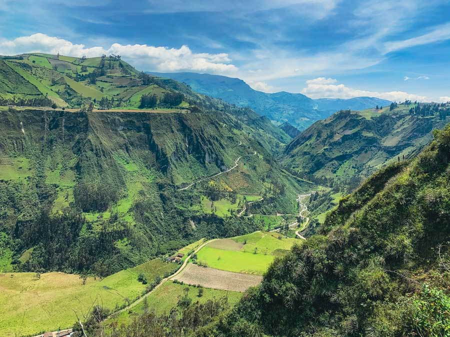
In Chinaló, stop by the mirador that offers incredible views of the Toachi Canyon. At the mirador, find a covered awning, a bench, and a garbage drop. The nearby community sells fresh fruit and some artisan goods.
The viewpoint is fantastic on a clear day!
🥾 Trail Logistics | Isinlivi to Mirador Cañon del Toachi | 5.75 miles | 3 hours 15 minutes
In Chinalo is a signboard that points to Chugchilan Village. Unfortunately, it meets up with a paved road that leads to Chugchilan.
Be aware that there was a landslide that rerouted the path right before the road near Chugchilan. The path leads through someone’s garden in which they ask for a donation for path maintenance with an honesty box.
The first marker of the village is the famous Black Sheep Inn. Other hostels are closer to the center across from the small cemetery.
Chugchilan Village

Chugchilan Village is a popular base for hikers looking simply to take day trips to nearby places, including a day hike to Laguna de Quilotoa. There is a famous cheese factory, Quesería San Miguelito that can be toured and there are lots of trails for horseback riding.
Where to Sleep in Chugchilan
Hostal Cloud Forest is known for their hearty plates of home-cooked food, central location, and for marking the Quilotoa Loop trail with signboards. They offer shared and private rooms and have fireplaces in the rooms that they light at night.
Hostal el Vaquero is located outside of the village, closer in the direction of Laguna de Quilotoa, and has beautiful green spaces and boasts its own sauna.
The Black Sheep Inn has luxury mountain huts with award-winning vegetarian meals, This is THE place to stay if you are sleeping for a few nights in Chugchilan. They have an all-day coffee and tea bar with delicious pastries. There are shared room options for $20 a night.
➜ More Chugchilan Guesthouses & Hotels
Hiking Quilotoa Loop Day 2 Logistics

- Distance: 8 miles
- Duration: +/- 4 – 5 hours
- Personal Schedule & Notes:
- I left Isinlivi at 8:30 with a to-go lunch. The lunch on day 2 was worth it!
- I enjoyed my picnic lunch at the Mirador Cañon del Toachi and walked into Chugchilan at 12:45, so I hiked for just over 4 hours for the day.
- The paved road into Chugchilan was my least favorite part of the Quilotoa Lake hike.
- Stop by Cafeteria Paquita to enjoy a pricey, but indulgent microbrew from the Golden Prague in Cuenca
Day 3 Quilotoa Loop Trek | Chugchilan to Quilotoa Crater Lake
On the final day of the Quilotoal Loop hike, there are two paths that lead to Quilotoa Lake.
The standard route that most hikers take passes through La Moya Baja and La Moya Alta.
Alternatively, there’s a quicker, but more steep “adventure route” that follows the outskirts of Guayama San Pedro community. Check in the hostels before departure, as sometimes the adventure route can be closed due to mudslides.
⁉️ It appears there was a recent landslide and the second bridge on the adventure route has been destroyed. While it can be passable, it requires careful navigation and proper gear. Always use your discretion and take any chances on dangerous paths.
Adventure Route

After the small community of Sigue, there will be a signboard that is marked as the “Adventure Route.” The grassy trail to the left begins the adventure route, otherwise, keep following the road straight to reach La Moya Baja.
Cross the the Sigue River via a rickety wooden bridge. There are plenty of markers for Quilotoa Lake. There is another makeshift bridge further up.
The second bridge is susceptible to being destroyed and unusable due to mud and rockslides. This bridge has been lost to a rockslide as of the summer of 2023.
From a reader (thanks Shaun), they suggest following the longer route on maps.me to Guyama Grande community. There is a trail to the right that ascends to the lake. This path merges with the Crater Lake viewpoint and takes a little over 4 hours.
Viewpoint & Guayama San Pedro


There’s an excellent viewpoint of the canyon below before arriving in Guayama San Pedro. Walk along the outskirts of town and follow the gravel path up.
This is a fairly large ascent but you can follow a few switchbacks to help speed up the process.
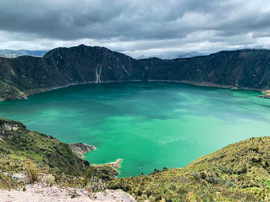
Finally, you will be rewarded with those first magical glimpses of Laguna Quilotoa.
First Quilotoa Mirador


There is a Quilotoa Mirador and observation deck right below a wooden snack bar. It’s free to enjoy the space.
Afterward, there are two paths a lower loop trail and a higher Quilotoa loop rim trail. Both trails are marked on maps.me, but STAY on the higher and more trekked path to avoid potential problems with the locals.
☛ Travel Tip | The “lower trail” is meant for livestock, so even though it’s marked on Maps.me and I took it for a bit, it’s best not to use this trail. I had an unpleasant encounter on the lower path, not unsafe just more of a nuisance
Quilotoa Village

Follow along the crater lake to the right on the higher Quilotoa Loop trail. This trek ends at the final Quilotoa Mirador which is across from Hostería Chukirawa.
There is an entrance fee to access the Quilotoa Community.
Quilotoa Community Entrance Fee: $2 USD, pay it upon exit or pay an authorized seller… they will give you a ticket
There are lots of restaurants and artisan shops here to browse. Some opt to sleep in Quilotoa for the night and hike the whole Quilotoa crater rim the following day or hop on a boat tour at the lake and maybe even rent a kayak.
The Quilotoa crater rim hike is also a popular day trip from Quito, so it can be busier than the previous hiking days, especially on the weekend.
The Quilotoa hotels and guesthouses are a little more expensive here since Laguna Quilotoa is one of Ecuador’s top attractions. If you want another day of hiking, sleep in Quilotoa and hike the following day to Zumbahua village. Zumbahua has even more frequent buses back to Latacunga.
➜ Browse the best Quilotoa hotels and hostels
However, you may be ready to head back to Latacunga. There are daily buses from Quilotoa Ecuador to Latacunga.
Hiking Quilotoa Loop Day 3 Logistics

- Distance: 8.4 miles
- Duration: +/- 4.5 hours – 6 hours
- Personal Schedule & Notes:
- I always opt for the “adventure route” when hiking, so I followed the left trail that passes through Guayama San Pedro.
- I left at 8:45 from the hostel with a sandwich to go. I arrived at the first mirador at 11:30 (around 3 hours) and hung out quite a bit there since I had great weather.
- The remaining section of the Quilotoa crater rim walk to Quilotoa village doesn’t take long.
- I arrived at the final Quilotoa Mirador in the village at 13:15.
Total Cost of 3-Day Quilotoa Loop Hike
So how much does it cost to hike the Quilotoa Loop in 3 days and 2 nights?
| EXPENSE | USD ($) | |
| Snacks from the Latacunga Market | $4 | |
| Bus Fare | Latacunga to Sigchos | $2.65 | |
| Night 1 Guesthouse Isinlivi | $15 | |
| Lunchbox | $3 | |
| Night 2 Guesthouse Chugchilan | $15 | |
| Microbeer in Town | $5 | |
| Sandwich to-go from Hostel | $1 | |
| Quiltoa Village Fee | $2 | |
| Artisan Goods & Snacks Along the Trek | $7 | |
| Lunch in Quilotoa | $4 | |
| Bus Fare | Quilotoa to Latacunga | $2.50 | |
| TOTAL | $58.65 |
It cost me $58.65 to hike the Quilotoa Loop trek in 3 days
Due to COVID, the trails and guesthouses were pretty much empty. I tried to purchase small things in each village, whether it was a man selling bracelets or a girl selling fresh fruit. These small villages en route which were once used to seeing hundreds of hikers per day pass through their communities are now seeing less than 20 visitors each day.
Most organized tours cost around $500 for 3 days, but if you seek a local guide in Quilotoa or Sigchos, it costs much less and the money stays within the communities.
Where to Next After Laguna Quilotoa?

After finishing the Quilotoa trek, return to Latacunga to pick up your excess luggage.
🚌 Quilotoa to Latacunga Buses | Average Fare: $2.50 | Duration: 2.5 hours | Current Departure Schedule: 5:30, 6:30, 7:00, 8:45, 10:45, 12:15, 13:45, 14:45, 15:30 16:15, 17:00, 17:30, but always verify current bus timetables
Maybe plan to hike in Cotopaxi National Park. Otherwise, head north towards Quito or south in the direction of Cuenca from the Valley of the Volcanoes.
Buses to Quito
🚌 Latacunga to Quito Buses | Buses Depart: every 30 minutes or less via multiple bus companies | Average Bus Fare: $3 USD | Duration: 2 hours | Buses Arrive in Quito @ Terminal Terrestre Quitumbe
Buses to Southern Ecuador

Most buses will stop in Ambato or Riobamba. From there it’s possible to catch a bus to the adventure capital of Ecuador, Baños de Agua Santa.
Farther south find the colonial city of Cuenca. The city boasts museums, markets, and plenty of worthwhile day trips from Cuenca. Hikers can enjoy the Cajas National Park or visit the El Chorro Waterfall. Make sure to soak those tired legs at the thermal pools near Cuenca. Cuenca has lovely artisan villages and even Inca ruins.
If you are seeking more hiking in Ecuador, stop in Alausí. This magic town is home to the famous Devil’s Nose train, but intrepid travelers can hike the Devil’s Nose, or “La Nariz del Diablo.” It’s also the gateway to the extremely intrepid Ecuador Inca trail that requires proper gear and above-average trekking abilities.
🚌 Latacunga to Alausi Ecuador | might require a transfer in Riobamba | Average One-Way ticket: $4 to Riobamba / $2 to Alausi ≈$6 | Duration: +/ – 4 hours
The Complete Guide to Hiking Quilotoa Loop in 3 Days
In conclusion, Laguna Quilotoa is one of the top attractions in Ecuador, and there’s no better way to experience it than hiking the Quilotoa Loop.
There are multiple Quilotoa hiking routes to choose from, but whichever path you choose, it will include stunning mountains, enchanting hamlets, and a chance to witness authentic life in the Ecuador Highlands. The Quilotoa Loop is named one of the best treks in Ecuador for a reason.
This definitive Quilotoa Loop trekking guide includes a Quilotoa Loop map that follows the north-to-south standard trekking route. Enjoy this relaxed 3 day Quilotoa Loop itinerary and appreciate one of the most popular stops along the breathtaking Ecuador Volcano Alley.
Walk slow with intention and feel the magic powers of the Andes Mountains. The grand finale is the glistening Quilotoa Crater Lake, the ultimate reward after 3 days of walking. Although it was incredible, to me, this trek was all about the journey, and the simple moments along the way.
Did you hike Quilotoa Loop? Did this 3 day Quilotoa Loop travel guide come in handy or are there any updates that I should know about? What did you think of this popular trekking route in Ecuador trekking route? Let me know in the comments below!
Pack This Post for Later! Pin It!


Disclaimer: There’s a chance this post contains affiliate links, and I receive a small (but grateful) portion of the sale. There’s no extra cost to you, and I only promote things that I use and love.


Wow, this looks incredible. I’ve heard great things about Ecuador and this just makes me want to go even more. I love multi day hikes but I like the sound of the guest houses instead of camping. Way more comfortable and less gear to carry
Thanks Emma! Yes it’s super nice and offers an excellent cultural experience as well. The food is worth the trek itself. 😊
The scenery is incredible! The waters of the crater lake is just a magical shade of blue. And everywhere on the trail is so lush. We’d love to visit Ecuador someday.
Thank you! It is a very beautiful hike and the journey is just as incredible as the Crater Lake. Hope you can make it to Ecuador in the future, it’s such an underrated destination.💚
The Toachi Canyon picture was just amazing! Love all the details, and even the exact price breakdown of the hike. Costs are so reasonable for such beautiful scenery. Thanks for sharing.
Thanks Erin! Yes, for three days it’s a very reasonable price ❤️
I’ve heard of this hike and was going to do it early 2020, but then Covid happened and I didn’t make it to Ecuador. I didn’t realize you can do a 3 day hike, but I will definitely do it one day—everything about it looks amazing! This is such a great in-depth guide. Thanks for sharing it! 🙂
Thanks Natalie! That is what is great about hiking Quilotoa Loop, there are many trail options to tailor to any itinerary. Hope you can make it to Ecuador in the near future 🇪🇨
WoW! That water looks like a sheet of jade. It takes my breath away. I want to be hiking here!
Thanks Terri! It’s a great reward after a three day hike! Although, the journey itself is where I found the most magic ✨
Finding your blog so helpful as I plan my trip to Ecuador. Will definitely be doing this hike. Thanks very much <3
Thanks Lottie! Enjoy! It’s a spectacular trek in Ecuador 🥾
I hate to be that guy, but I want to hike the loop and need general internet availability. Do you remember how much service you had? Can I count on finding pockets of service every couple of hours?
Hey Noam-
Unfortunately I didn’t take my laptop with me, but I do remember connecting my phone to some Wi-fi points at the hostels. Some places didn’t accept cards, so they might not have Wi-fi.
Just remember that the weather can change in the mountains and there are afternoon clouds and storms, which can also affect the connection.
There are two pretty modern hostels, The Black Sheep Inn in Chugchilán and the LluLlu Llama Mountain Lodge in Isinlivi. Those may be two places to check in and who could be more help.
It’s a great hike, so hope you can enjoy it!
Thank you Megs. Very helpful. I’m in Tena right now, heading to Banos tomorrow, then Latacunga early next week. Aways good to get advice from people who have actually done the hike. Cheers!
Enjoy the trek! I really did love it, and it was pretty quiet when I hiked it. I love the experiences of the almost house-like stays in the small communities.
Safe travels ⛰
Hi. Just done the trek and found your guide very useful. For day 2 there is an alternative route from Itualó that joins the main road into Chugchilan much later if you don’t want to walk along the main road. I went your route however and agree, the mirador is a great place for lunch, and the road whilst not much fun isn’t busy
On the last day the second bridge you mention has been taken out by a rock slide. It’s marked on maps.me as danger, path broken. You can get by, by scrambling over the stones but good foot ware is required. However there is a third route. Follow the longer route on maps.me to Guyama Grande but then turn right and head straight to the lake. The path is marked on the map but maps.me doesn’t suggest it for some reason. We went along it and it was fine and from Chugchilan to the view point of the lake took us just over 4 hours.
Thank you so much for the feedback and update Shaun. I’ll go in and update this week. 🙏
Have they pulled all the signage for the adventure route due to the landslide and broken bridge? I wonder if they will permanently close the alternative route?
Happy Trails,
Megs
Hi Megan, no, the sign off to the left of the road for the adventure route is still there. As I say it’s passable but with care 😊
Hi Megan,
Thanks a lot for this wonderful guide!
I am planning to do this route in March next year – hoping the weather is not too bad. Do you think it’s not a good idea?
Also, I wonder if it is necessary to book the guest houses in advance?
Thanks for your help!
Best, Sofie
Hey Sofie-
Thanks for reaching out. I’m not sure about the weather in March, it seems as if the weather across the globe has unfortunately been fluctuating quite a bit. In January, I had great weather, but in the mountains the weather can always change fast. It’s best to pack in layers with good rain gear and warm clothes for at night. There are always local guides in the villages if you are concerned about the weather and almost always other hikers on the trail.
As for booking in advance, I would suggest doing what you feel most comfortable with. There are plenty of places along the way and many of them are on booking.com. Most hikers follow the same path through all the villages, so it doesn’t hurt to book in advance, especially if a certain place calls to you.
Happy Hiking,
Megs
Hi Megan,
Just to say thank you for your post and the map which I downloaded into Maps.me. I didn’t try the adventure route on day 3 (signs still there but hostel owner pointed out the non-adventure route which still held enough adventure for me!).
At the end of the second day the path is re-routed through someone’s garden (just before you join with the road near Chugchilan) due to a landslide in 2022. The owners ask for a donation for path maintenance (with an honesty box).
All hostels now seem to have good wifi (with the exception of the programme of rolling power cuts in Ecuador at the moment)
Hey Rachel-
Thanks so much for taking the time for reaching out about this important update! It seems like the path will constantly be changing with the landscape. I will add this update to the post.
Cheers,
Megs
Hi Megs, I finished my first day of the trek and your blog has been incredible! Thank you for the detailed descriptions! I’m looking forward to day 2 and the wonderful journey!
Thanks so much Cyndi! Glad that the hiking guide has been useful for you!
Happy Hiking,
Megs
Hi Megs!
I’m planning to do this trek in Nov., fingers crossed that 2024 Nov won’t be the wettest Nov ever 😁
Couple of questions, hopefully you can help- someone mentioned tickets/fee for the loop, is that right? 🤔 don’t think I read that anywhere on your blog…
Also, will our phones work thru out the trip (data) or Shd I take my satellite device (we are 3 gals)???
Thanks 😊
Hey Anjua-
You will love the Quilotoa Loop. I hiked in January and it was so green. I started early in the mornings and it usually started raining by the afternoon.
There is a fee to access the community of Quilotoa. The fee is $2. You may be approached near the lake or on the way out because an official community member will ask for a ticket. As I was leaving for the bus stop I was asked at the gate for my ticket and paid the $2 fee to the community. Make sure you hold onto your ticket as you will be asked for it within the community.
As for the trek, there is no official fee per se. Some readers have informed me that due to landslides some of the routes now pass through a local’s land and they have set up a donation box before Chugchilan.
The Quilotoa Loop hike is quite popular, so you will see other hikers. There were some sections of the trail where I didn’t have service, but I did not carry a satellite device. I did have an offline map, but if you feel more comfortable with a satellite device, there is no harm in carrying one. I have heard that the internet in the guesthouses in each village has also drastically improved.
Hope this helps and enjoy your trek! 🥾
Megs
Hi Megs, your post is the most detailed I found on the internet and it was a useful help on my Quilotoa loop trek. Thumbs up!
I found it a better option to spend the night directly in Sigchos instead of Lacatunga. Lacatunga is not very interesting and as a person who prefers to spend time in nature, I would avoid it. There is a direct bus from Quito to Sigchos, I recommend using it to save a lot of trouble with changing buses at Lacatunga. The direct bus runs every day except Sunday at 4pm. There is a beautiful Starlight Inn hostel in Sigchos where you will get a warm welcome and amazing dinner and breakfast with a breathtaking view of the canyon. Another bonus: you can start trekking right after breakfast! Hope that helps.
Thank you so much, Patrik for this helpful trip update!! It’s such a beautiful trek and I am glad you enjoyed it
Hey Megs, just want to thank you for this fantastic blog post! I did the Quilotoa loop in mid-October 2025, pretty much based on your recommendations. I used maps.me without which I would definitely get lost (the trail is not always marked). There are also of the trail that no longer exist due to landslide, I wish I could edit this in the map – at one point I was standing at a cliff.
I started in Latacunga, in the morning I took a bus to Sigchos. Stayed at Hostel Taita in Insilivi, was 16 USD/night incl. dinner and breakfast. Cloud Forest the night after was for 15 USD, also incl. dinner and breakfast. The last day I took the extreme route, took me 3hrs to see the lake for the first time and then another 1,5h incl. lunch and many stops to get to the Quilotoa village. Here I walked outside the village to get on the bus back to Latacunga.
Hey Martin-
Thanks so much for the updates. It’s hard as the routes are always changing due to landslides, extreme weather, and other natural causes. I think Maps.me is an amazing source, and is what I always use and build my maps from. The app itself usually provides fairly good updates, and edits are allowed within the application.
Thank you also for the updates on the prices of your multi-day trek. Did you like it? It was one of my favorite multipday treks in Ecuador.
Megs