
Overview of the Incredible Camino de San Salvador in 6 Days
There’s a famous saying about the Camino de San Salvador. “Quien va a Santiago y no al Salvador visita al criado y olvida al Señor.”
It translates to something like “Whoever goes to Santiago and not to El Salvador visits the servant and forgets the Lord.”
There is one thing for certain, I will never forget the beauty and the power of the mountains on this Camino route.
The Camino de San Salvador is a route through the mountains that connects León on the Camino Frances to Oviedo, the starting point of the Camino Primitivo. The reasoning for this route was for pilgrims to stop at the Cathedral of San Salvador in Oviedo to gaze upon the Holy Shroud that was said to cover the face of Jesus after the fateful day on the cross.
The Camino Primitivo is also a significant Camino de Santiago route as it was said to be the first Camino route walked by King Alfonso II. He was said to walk a similar way to verify the relics found in the meadows near Santiago de Compostela were in fact those of the Apostle St. James.
Oviedo and the Cathedral of San Salvador are the second most significant pilgrimage sites. This connector route helped pilgrims move between the Camino Frances and the Camino Primitivo to Santiago de Compostela.
The Camino de San Salvador is different than you’re typical Camino de Santiago route. Services are limited, the mountain stages are challenging, and it’s quite remote. However, it is one of the most spectacular Camino routes.
This general guide is an overview of the Camino de San Salvador. It includes useful tips and resources, my personal walking stages, and how much it costs on average to walk this mountain route.
Here’s a useful guide for planning the Camino de San Salvador route.
Table of Contents
Disclosure: This is part of my Hikes & Adventures series, which means these treks can be strenuous and challenging. These are my experiences and I am not an expert. Please have all the proper equipment, verify the weather conditions, use professional resources, do your own research, be mindful of constantly changing trail conditions, and take into consideration your own physical abilities and/or limitations. These guides are for entertainment purposes only. Please see my full disclosure for more information here.
- Overview of the Camino de San Salvador
- How the Camino de San Salvador is Different Than Typical Camino Routes
- What to Do Before Departing on the Camino de San Salvador
- Useful Tools for Walking the Camino de San Salvador + Tips
- My Personal Camino de San Salvador Route
- Arrival in Oviedo Spain
- How Much Does it Cost to Walk the Camino de San Salvador?
- Conclusion | Camino de San Salvador in 6 Days
Overview of the Camino de San Salvador

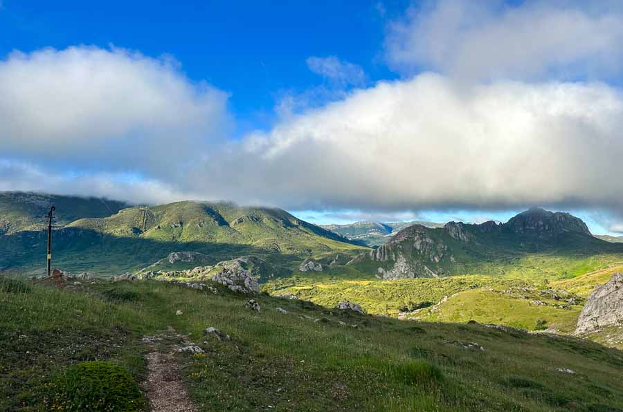
The official starting point of the Camino de San Salvador is right before the Plaza San Marcos of León. The trail twists through the mountains and small hamlets. It moves through the region of Castile and León and onto Asturias region. The end of the Camino de San Salvador is in the Plaza de la Catedral in front of the memorable San Salvador Cathedral in Oviedo.
The Camino de San Salvador is officially marked at around 75 miles (121 KM). Although, don’t let the distance of this one fool you. There are plenty of ascents and descents through the mountains. The trail is tough but rewarding.
Most pilgrims walk the Camino de San Salvador over five or six days
As this is a mountainous route, it’s best to walk this route in the summer or shoulder season. The months of June through August are ideal. The shoulder months of April, May, September, and October are nice, too, but be mindful of daylight hours and weather changes.

The Camino de San Salvador is still not an extremely popular route, as it’s not for everyone. You won’t have to worry about it being too overcrowded. When I walked, I saw about 8 – 10 different pilgrims moving through different stages and in different directions.
The Camino de San Salvador is not necessarily recommended during the winter months when the weather can be volatile. This mountain range does get snow which comes with risks. Some of these mountain passes are between 3,000 – 5,000 feet, so some technical skills are required. There is also limited daylight during the winter months, and some stages can be long.
In the winter, many guesthouses and restaurants shut down, so planning in advance and carrying extra food is essential. Winter walking also required a different packing list.
I walked the Camino de San Salvador at the end of June / early July and had fantastic weather.
Most pilgrims will then choose to walk the Camino Primitivo into Santiago de Compostela. From Oviedo, Santiago de Compostela is about 2 weeks via the Camino Primitivo.
Can you Walk the Camino de San Salvador Backward?

The typical route for the San Salvador Camino is from León to Oviedo. For me, this makes the most sense as you arrive at the Grand Cathedral in Oviedo to collect The Salvadorana Certificate for completing the route. A nice surprise is the free entrance to the Cathedral, which is spectacular.
It is possible to walk from Oviedo to León. You’d have to be diligent with signage, as most of the arrows are seen walking in the direction of Oviedo. However, I saw a couple who were walking to León where they would continue to Ponferrada to walk the Camino de Invierno and onto Santiago de Compostela
How the Camino de San Salvador is Different Than Standard Camino Routes
The San Salvador Camino route is different than the standard and more popular Camino de Santiago routes. This is more like a hike through the mountains than a walk across Spain. It’s important to note that this route may not be for everyone. Keep in mind your physical limitations and abilities.
These Camino de Santiago tips may also come in handy. If feeling overwhelmed about where to start, browse all my Camino de Santiago resources.
For me, it was an incredible journey through the untouched mountains in Spain.
Fewer Services

The Camino Frances has one of the best infrastructures on any Camino de Santiago route with tons of Albergues, so if moving to the Camino San Salvador you’ll need to be prepared.
Services are a lot more limited and it’s best to call a day in advance to the next village to reserve a bed and sometimes a meal. This was something different for me, as I never usually plan or book anything in advance. Oftentimes if you don’t call for a meal for the end of the stage, chances are you may not get one.
For this reason, it’s also smart to carry a meal or two worth of food, just in case.
It’s Quiet
For me, the true beauty of this Camino I found in the mountains, in the quiet solitude of nature. In the vastness of nature, you can hear the chirping of birds, the sounds of cowbells, or the ringing of distant church bells.
Many of the tiny mountain pueblos only have a few full-time residents.
If looking for a social Camino route, this may not be the route for you.
Weather
Weather is another factor for walking this Camino route. Anytime you hike in the mountains the weather can change in an instant. Things like heavy rain or fog should not be taken lightly. As some of these trails are remote, the risk of injury is something to be concerned about.
Be mindful of your own physical limitations and carry the proper gear.

But At It’s Core… It’s Still a Camino Route
The Camino de San Salvador is still a Camino route at heart. In fact, it feels probably more like an authentic way for those pilgrims who walked during the Middle Ages. There is a camaraderie and spirit found on this Camino route, especially in the small communities you pass through.
Many of these albergues are found in local people’s homes, some of whom provide food that comes directly from their gardens and is made with love. They simply ask for donations. The Albergues on the Camino de San Salvador are some of the best I’ve ever had the pleasure of staying at along any Camino route.
You’ll still see the yellow arrows twisting you through the mountainsides. There are hearty pilgrim meals (just call in advance) and a few sacred sites to see along the way.
Buen Camino.
What to Do Before Departing on the Camino de San Salvador from León
There are a few things to do in León before departing on the San Salvador Camino.
1 | Stop at the León Albergue

Albergue de Peregrinos del Monasterio de las Benedictinas, or Albergue de las Carbajalas is the main pilgrim albergue in León. Even if you decide not to sleep here, this is a great place to get up-to-date information about the Camino de San Salvador route. As I was checking in to the Albergue a woman who had just finished the route was able to inform me of where to stay and what restaurants were open.
If looking for a no-frills place to sleep in León that is supportive of pilgrims walking the Camino de San Salvador, stay at the Albergue de las Carbajalas.
However, there are tons of places to stay in León if looking for solitude. At least stop by to pick up the credencial and check in with current updates.
This Alberuge is also where you can pick up the official Ruta de San Salvador Credencial del Peregrino for 2 Euros. While many pilgrims just use their Credencial, or Pilgrim passport from their Camino route, the San Salvador Credencial has tons of useful information.
On the booklet are all the Albergues on the route with contact information. Additionally, there are services from restaurants to tiendas, pharmacies, and tiendas listed by each village on the Credencial.
As I had completed the Camino Portuguese beforehand, I purchased the Credencial for the San Salvador route and it was so worth it!
The Albergue de las Carbajalas is simple but set in town next to the Plaza del Grano. There are tons of services nearby from laundry, grocery shops, cafes, and more. The volunteers here are so helpful. Rooms are simple dorms separated by men and women and there is a kitchen. Breakfast is offered by donation.
Albergue de las Carbajalas | Find it here: Pl. Sta. María del Camino, 7 | Pilgrim Credencial Required | Beds: 96 | Cost: €10 (Suggested Donation)
2 | Replenish Supplies & Money

León is a large city with all the amenities. If you’re adding the Camino de San Salvador as a connector route, then you may have been modifying your Camino packing list as you’ve been moving.
I walked the route in the summer, so my Altra Lone Peak Trail Runners worked fine. If walking on the shoulder season, a good pair of hiking boots is ideal to help with muddy trails and slippery rocks. Hiking poles help with balance and your knees and navigating the rocky terrain.
Be prepared with layered clothing as the weather in the mountains can change drastically fast. Carry plenty of water in a reusable water bottle. Fountains are less available in the mountains.
If sleeping in the Municipal Albergues, a lightweight sleeping bag is necessary. This past Camino, I carried a Sea to Summit Spark Ultralight 40F Sleeping Bag and loved it.
Additionally, I carried 1 day’s worth of food and extra snacks in case things were shut in town. There will likely be cafes, but for the stretches in between I relied on snacks.
I typically carry around 300€ when starting on my Camino routes and replenish as I go. As this is a route through small communities, smaller bills are better.
➯ Hey… don’t forget your Travel Insurance! I love SafetyWing
3 | Relax

León is a large and bustling city. There’s a lot to see from the stained glass Cathedral to the Royal Pantheon at the Basílica de San Isidoro. Many pilgrims take a rest day here. León also has a fun tapas scene.
So, relax. Drink plenty of water and stay hydrated. Mentally prepare for the Camino and set intentions to leave early for the first stage of the San Salvador Camino.
Useful Tools & Guides for Walking the Camino de San Salvador
By far the best guide for the Camino de San Salvador is written by a Spanish gentleman, José Antonio Cuñarro, or Ender. His guide to the Camino de San Salvador is detailed with step-by-step directions and maps. His guide is the most up-to-date and there is typically a copy in every albergue or highlighted notes for the next day’s walk.
He also runs the Camino del Salvador Facebook Group which has the entire stage-by-stage guide with maps. The most recent guide is pinned to the top of the Facebook Page.
Pilgrims are quite active in the group with weather updates and trail closures.
More useful Apps and tools for Walking the Camino San Salvador
- Wise Pilgrim ($2.99)
- Gronze has a basic guide, which isn’t always up to date.
- Maps.me or another offline map essential in the mountains as some of the trails merge with other routes or markings can be questionable.
- I record all my routes with Wikiloc and numerous people have recorded routes on these trails in the mountains
- Google Translate is useful, especially in small towns where English is uncommon.
- WhatsApp for reservations for beds and food in rural communities (Most are not on any accommodation website like Booking.com)
This is not a standard Camino de Santiago route so there are no bag transfer services. There are some local bus services between some communities, but not all. Remember, a majority of the way is on mountain trails.
My Personal Camino de San Salvador Route (6 Days)

This was my personal Camino San Salvador Route. The official signage says this route is 77.7 Miles (125 KM), but I walked 79.9 Miles (128.6 KM)
- Day 1 | León – La Robla | 17.8 Miles / 21.2 KM | + /- 6.5 Hours
- Day 2 | La Robla – Poladura de la Tercia | 14.6 Miles / 23.5 KM | + /- 6 Hours
- Day 3 | Poladura de la Tercia – Pajares | 9.5 Miles / 15.3 KM | + /- 5 Hours
- Day 4 | Pajares – Bendueños | Distance: 11.4 Miles / 18.3 KM | +/- 6 Hours
- Day 5 | Bendueños – Mieres (El Rollo) | 17.3 Miles / 27.8 KM | + /- 7 Hours
- Day 6 | Mieres (El Rollu) – Oviedo | 9.3 Miles / 15 KM | + /- 4 Hours
Most pilgrims walk the Camino de San Salvador over 5 or 6 days. Aggressive pilgrims could walk the mountainous route over 4 days, but that first day would be really intense. There are enough accommodations that the connector route could be casually walked over 8 or 9 days.
If the weather changes, you may have to be flexible with the days and logistics. Never put yourself in harm’s way.
These are just basic overviews of my daily Camino de San Salvador walking stages and highlights along the way. Remember, walk your own Camino!
Jump to | Day 2 | Day 3 | Day 4 | Day 5 | Day 6
Day 1 | León – La Robla
- 17.8 Miles / 21.2 KM | + /- 6.5 Hours
- Accommodation: Albergue Municipal de La Robla | Bed: 8€


To reach the official divergent route off the Camino Frances to the Camino San Salvador head to the Plaza de San Marcos. If you haven’t walked to this plaza before, don’t miss the chance to visit the weary pilgrim statue resting his feet.
You’ll turn off for the Camino de San Salvador to the right before the Monastery of San Marcos. For a luxurious experience, you could sleep in the 5-star Parador de León connected to the Monastery the night before.
There are very distinct markers showing the Camino Frances and the Camino de San Salvador route, both on purple boards and spray painted on the sidewalk. It’s fitting because you leave León on the street Av. los Peregrinos.
Like many variant routes, like the Camino Espiritual and beyond, the Camino San Salvador has their own signboards. There are still yellow arrows and traditional blue and yellow signboards, but the Camino de San Salvador has wooden signboards with yellow lettering. The signboard also notes the way through the Cuatro Valles (4 Valleys).
The first segment is on sidewalks through the city. Once after the village of Carbajal de la Legua, the trail leads to a dirt road.
There are lovely views of the mountains and some benches to sit on and take a rest. There are no services until La Seca, which requires a short detour.


Cabanillas has a Municipal Albergue next to a small church. There are no restaurants in town, so you’ll need to bring food if planning on sleeping here. Find a water fountain in the village.
The way continues on forest trails alongside the Bernesga River. There is a chance to detour over the bridge to grab food in La Seca, otherwise continue along.
Cascantes is the next quiet village with a nice water fountain. Towards the end of the village are two alternative paths to reach La Robla. The signboards are clearly marked.
✔ To the left is La Robla por Llanos de Alba (6 KM on a dirt path)
✔ Straight ahead is La Robla por Ermita de Celada (5 KM on the asphalt)
I always try to take the dirt paths, so I turned left for Llanos de Alba. It’s a nice walk through the meadows and runs somewhat parallel to the train tracks.

Join the asphalt road to walk into La Robla. I opted to stay outside of the center at the Albergue Municipal de La Robla. The basic facilities have a well-stocked kitchen and is next to a large open park.
It’s very common on the Camino San Salvador route that the hospilaterio (who runs the Albergue) will show up at a designated posted time to collect payment and stamp your Credencial. Be mindful of the time on the arrival board, which usually posts updates and information for the next day’s walk.
Most pilgrims stop at Poladura de la Tercia where food reservations are essential for the next day. Call Hotel Rural Posada el Embrujo to make reservations for the next day (breakfast, lunch, dinner, and rooms. (+34 659 030 282)
The restaurant in La Robla next to the Albergue was closed, but there were a few places to eat in the main plaza (taps and menu options). There are two nice grocery stores in La Robla, too.

More Places to Stay in La Robla
Day 2 | La Robla – Poladura de la Tercia
- 14.6 Miles / 23.5 KM | + /- 6 Hours
- Accommodation: Albergue de Peregrinos de Poladura | Bed: 9€
Day 2 of the Camino de San Salvador includes more stunning scenery through the mountains.
Leave La Robla and walk past a stunning Roman bridge. The next point of interest is Santuario de Nuestra Señora del Buen Suceso, a small church. The dirt path leads to La Pola de Gordón. There are quite a few services here including the Hostal Fontañán and a grocery store. I had a great coffee at Café Bar Español.


Continue out of town past a small chapel. The wolf statue on the cliff welcomes pilgrims into Buiza. There is a municipal albergue but no restaurants, so you’ll need to carry food supplies if planning on staying here.
Buiza is a lovely village, but the adventure begins with the ascent up the hill along the way. It’s clearly marked and there are stunning views of the village behind as you enter the Reserva de la Biosfera-el Alto Bernesga.
It’s a steep climb to the Forcadas de San Antón pass at 4,788 feet (1,458 m), but it’s the highest point of the trek today. It took me about an hour to climb from Buiza to San Antón Pass.
Savor the views of the valley that you descend. This is an ideal place to take a break.
The trail descends where you must be mindful of the yellow arrows.
After the second water pump facility make sure to turn left. Continuing straight will take you to Rodiezmo de la Tercia, but you must take the small dirt path up the hill to head towards Poladura de la Tercia. There are reminders in the albergues the night before, but make sure to pay attention to the arrows.


This next trail section is spectacular as it weaves through meadows and the rockside. There were tons of horses in the fields when I was walking that only added to the magic.
Continue to the tiny village of San Martín de la Tercia with its mural pointing the way to Poladura de la Tercia. There is a path that takes you over a wooden bridge to avoid walking into Poladura de la Tercia on a dangerous road.
Poladura de la Tercia is a small village decorated with painted rock art and lots of flowers and plants. More sheep walk through the village than pilgrims. I absolutely loved this mountain hamlet village.
Hopefully, you reserved dinner at the Embrujo Restaurant that’s connected to the guesthouse! They have a large garden patio to sip on wine and relax before dinner.

The Albergue is simple. Again, the hospitalerio will collect money and stamp passports sometime before dinner. There is a basic kitchen and a one-room dorm with bunk beds.
For the next stage if planning on sleeping in Pajares, make sure to call and reserve meals for the Bar in Pajares. Otherwise, there will not be a meal option for dinner on day three. (+34 636 933 069).
Poladura de la Tercia was one of my favorite villages on the Camino de San Salvador and makes an excellent place to stop before hiking up the tallest pass on the route in the morning.

Day 3 | Poladura de la Tercia – Pajares
- 9.5 Miles / 15.3 KM | + /- 5 Hours
- Accommodation: Albergue Antiguas Escuelas | Bed: 8€
Day 3 of the Camino de San Salvador takes you straight through the heart of the mountains. It’s stunning and definitely a memorable day. Although the distance is short, it feels longer due to the ascent up to Coito Hill and descent into Pajares.

Once you leave Poladura de a Tercia it’s a breathtaking climb up to the Cruz de San Salvador on the Alto de Los Romeros The views here are spectacular and is an excellent option to rest before coming up to the tallest pass of the whole hike, Coito Hill. The pass is marked by a cross at 5,177 ft (1,578 m).
It’s a little bit of a descent, but you can see the path on the mountainside to the left that you must take to reach Arbas del Puerto. The yellow arrows lead up the hillside, but take one more epic view of the valley and where you came from before following the way down towards Arbas del Puerto.
The trail leads towards Arbas del Puerto where you can see the impressive Colegiata de Santa María. The village remains mostly abandoned and the church was shut on my day of visit. Once leaving Abras, we are leaving Castile and Leon and entering into the lovely Asturias region of Spain.
Continue on the way to Puerto de Pajares. There’s an old Parador hotel that has a cafeteria with incredible views of the Mountain Pass here. The Camino route is before the Parador, so just detour back to rejoin the official route.


There is also a goat path from the Parador that follows the highway to the trail marker to Pajares, which I wish I had taken instead.
On the official route there is some construction happening in this area (making a large road) so be mindful of changes along the way. This trail will cross the highway to the signboard for the Camino.
There are two route options, one to Pajares and another to San Miguel.
I followed the route into Pajares. If not staying in Pajares, continue to San Miguel. Casa Guela is a place to sleep in San Miguel or a few kilometers farther is the Albergue in Llanos de Somerón.
On the way to Pajares is a beautiful forest section, but keep in mind it can be pretty muddy if it rains or is in the shoulder season. Be conscious of the arrows as one area I ended up on the busy highway, which is dangerous. I re-routed until I found the shell marker buried behind the overgrowth. Walk past the cemetery and come up into Pajares.

Pajares is a fabulous village with incredible views of the mountains. There is a lovely water fountain, church, and one bar/restaurant (hopefully you reserved dinner). The bar does serve some snacks if you get in early and are hungry (chips and empanadas). The dinner is hearty!
The Albergue is in an old-school house and has stellar views. There is no full-service kitchen here, but there is a microwave and a small vending machine onsite.
If planning to stay in Bendueños the next night, you’ll need to call and let Sandra know you are coming. She provides meals, snacks, and breakfast so it’s best to call the day before. ( +34 674 671 706)
You’ll sleep peacefully in the charming village of Pajares.

Other Places to Stay in Pajares Asturias
- Pensión El Mirador
- Casa Rural Posada Real de Pajares
- Valle del Sol I
Day 4 | Pajares – Bendueños
- 11.4 Miles / 18.3 KM | +/- 6 Hours
- Accommodation: Albergue Bendueños | Donativo (includes food and all meals)
On day 4 of the Camino de San Salvador, most pilgrims opt to sleep in Pola de Lena. However, the donativo albergue in Bendueños is spectacular and has been my favorite albergue on any Camino de Santiago route.

Leave the Albergue from Pajares to come to San Miguel del Río. This is where the other route the day before would have led instead of to Pajares. The village is small and has the Casa Guela accommodation option.
Follow the arrows uphill through the forest. The route through Llanos de Somerón is recommended due to dangerous road conditions.
In the early morning, fog may cover the valley. The path leads to Llanos de Somerón. Llanos de Somerón has a church and the highly recommended Albergue Cascoxu that offers homecooked meals (make sure to call in advance (+34 656 284 603)).
The views the entire day are awesome. Not long after Llanos de Somerón there is a detour split for the “high road” to Fresno Ruta por Munistiriu or the roadway to Frenso Ruta por Carretera. The Ruta por Munistiriu (Monastry) is a challenging route through the mountains and includes steep cliffs and narrow paths on stones. The Ruta por Carretera is easier but follows along the road.
The Ruta por Munistiriu is best for hikers who feel comfortable in the mountains. It should not be attempted during bad weather or volatile weather. It is also susceptible to rockslides and can be closed due to dangerous conditions. The Camino del San Salvador Facebook Group is a great place to check on current conditions.
Ruta por Munistiriu (Old Monastery Route)

(PR-AS 99) | Distance to Fresno: 5.2 KM | Difficulty: HARD (From the Official Signboard)
It’s a steep uphill to leave the road and follow the high trail to Fresno. There are lots of abandoned buildings being reclaimed by the mountains. The path is through a forest and it changes to steep cliffs. This is a local route, so besides the occasional arrows look for yellow and white blazes.
When I walked, there was no more chain to assist hikers up the mountainside, rather newly installed metal “steps.” This section is kind of scrambly and there are signmarkers sprayed on the rocks. Be especially mindful of the giant X sprayed on rocks that indicate to not enter as they are cliff drop-offs.
At this section of the trek, I was followed by curious goats. The views here are also spectacular but be mindful of your footing and the trail.


The trail continues through the forest to an old abandoned monastery. It has been mostly reclaimed by the land. The path can be hard to follow and I ended on a goat path to a local residence.
Really be mindful of markings to rejoin the Camino at the fountain in Puente los Fierros. I noticed that this local trail was not entirely marked on my offline map either.
Puente los Fierros
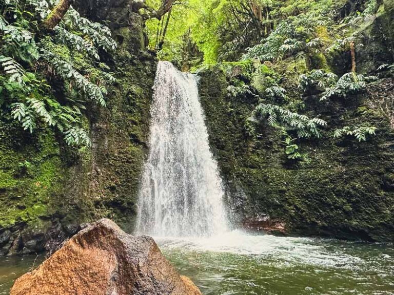
If you take the Monastery route, the fountain is an excellent option to rest, replenish water, and have snacks. The way continues through the forest with trickly waterfalls, old watermills, and rich forests. This path is clearly marked and soon you’ll come to the first views of Herias.
Most pilgrims will continue through Herias to Campomanes and onto Pola de Lena to sleep.
Albergue Bendueños Option

However, I think the detour to Bendueños is a fantastic detour. The Albergue is found off the main way a total of 1.5 Km (just under a mile) right before the village of Herias. There is a direct signboard indicating the detour.
Don’t be fooled by the short distance, the last climb to the hostel is up a steep road. The rewards of sleeping at Bendueños will make that climb more than worth it.
Sandra is a warm host who hands over the keys to the church across from the Albergue. Expect a well-stocked kitchen and food fresh from her garden. There are eight beds here and it’s all by donation. A new bonus is the washer and dryer. Can we also talk about those views from here?
Donativos are not free, but rather to help pay for the next pilgrims’ stay. Think of those before you who paid to allow you the privilege to stay and eat here. Pay it forward.

Day 5 | Bendueños – El Rollo (After Mieres del Camino)
- 17.3 Miles / 27.8 KM | + /- 7 Hours
- Accommodation: Casa Alba | Donativo (Make sure to call in advance +34 624 833 403)
- Most pilgrims Opt to Sleep in Mieres del Camino
Day 5 of the Camino de San Salvador is not as scenic as it passes through many villages on the pavement. It also has sections that run parallel to the busy highway A-66. But not every day on the Camino can be magic and as a bonus, there are many services along the way (bars, cafes, grocery stores, pharmacies, etc.)
There is the opportunity to visit the Pre-Romanesque Church of Santa Cristina de Lena.
If you slept at the Albergue Bendueños follow the same road you came on to rejoin the Camino route. We asked Sandra about some of the footpaths and alternative trails, but she advised us to follow the road back!

The trail leads through Herias and onto Campumanes which has plenty of services. The way continues along a paved path that follows the Rio Lena and next to it the busy A-66.
The Church of Santa Cristina de Lena is about 3.5 miles from the Buendueños Albergue, so it won’t take long to reach. It’s a short few hundred meters detour off the Camino de San Salvador.
The Church is unfortunately closed on Mondays (which is what day I arrived here). However, the exterior is still worth visiting. The church’s hours are limited, but if lucky pay €2 to see this impressive UNESCO World Heritage Site.
The trail continues to Pola de Lena with lots of services and onto Ujo with the beautiful Church of Santa Eulalia de Ujo. From here follow the Cuadal River on the path to cross into Mieres del Camino.

Most pilgrims sleep in the village of Mieres del Camino, a town famous for its Asturias Cider. I kind of skipped past the village as my knee was bothering me. It had been a pretty long day and I took lots of breaks. I followed the main road through the village and grabbed groceries.
I continued to follow the way out of Mieres del Camino to sleep in El Rollo at Casa Alba. It follows the way past Hostal La Peña on the AS – 375. This fantastic albergue is another donativo Albergue run by Alba de Carmen.
Carmen is so sweet and offers her home to pilgrims. There are no services nearby, so you need to pick up food and groceries in Mieres del Camino. Find a spectacular garden, access to the kitchen, clean rooms with bed sheets, and her sweet little pup. It’s a treat to sleep here as she provides bed sheets!
The Albergue is found on the road and is about an hour’s walk from Mieres del Camino.
Day 6 | El Rollu – Oviedo
- 9.3 Miles / 15 KM | + /- 4 Hours
- Accommodation: Albergue de Peregrinos de Oviedo | Bed: 7.50€
- More Places to Stay in Oviedo


Today is the final stretch of the Camino de San Salvador to Oviedo.
There’s still a little bit of a climb until El Padrún and then look for the dirt path to Casares. The next point of interest is right before Olloniego, where you’ll see the final 10 KM to Oviedo posted on a signboard.
Once through the village find the Bernaldo de Quirós Palace and the Muñiz Tower to the left. There are remnants of an old Roman bridge and benches here if looking for a place to rest.
The signage can be tricky after this but cross over the Nalón River via the car bridge. I took a footbridge which was a mistake and I had to backtrack to the original way. Look for the arrows pointing uphill. Yes, there’s still another climb to Oviedo!

The uphill route is marked with a signboard Senda Verde. This climb is along a Roman Road to El Picullanza, the tallest point of the day. The way has another “hill” that twists through small hamlets and eventually descends to Oviedo.
The first views of Oviedo are quite rewarding after hiking for 6 days through the mountains.
Although you’re walking into a city, this is a beautiful stretch of trail with panoramic views of Oviedo and the countryside.

Arrival to Oviedo Spain
The Camino de San Salvador ends in Oviedo in front of the impressive Cathedral of San Salvador of Oviedo. This was the capital of the ancient Kingdom of Asturias and played a significant role in the spread of Christianity.
The San Salvador Cathedral of Oviedo is one of the most significant cathedrals on any Camino de Santiago route.
Oviedo was one town during the Middle Ages that was never conquered by the Moorish Empire.
Today it’s a lively university city with parks, a condensed historical center, museums, and a youthful vibe.
The way passes by the Municipal Albergue de Peregrinos de Oviedo. Be mindful that they don’t open until 14:00 (16:00 in the off-season), but sometimes they allow you to drop off bags so you can visit the Cathedral.

The Municipal Albergue also offers the Salvadorana, the certificate for completing the Camino de San Salvador route for a fee. The Oviedo Cathedral will issue the certificate for free. The Salvadorana includes free entrance to the San Salvador Cathedral in Oviedo.
The Cathedral de San Salvador is worth visiting inside. The church was constructed during the 9th century but includes a mixture of architectural styles as it has changed throughout the centuries.
Remember, if you complete the Camino de San Salvador route from León to Oviedo, admission to visit the Cathedral of San Salvador is free.
One of the most significant sights is the Holy Chambers which contains relics and the supposed Holy Shroud that covered the face of Jesus after he was crucified on the Cross. But if you look close enough, you can still see connections of pre-Roman religions (plaques to the sun and pagan origins).


Oviedo has beautiful plazas, gardens, and a lovely historic Old Town. If you have. a few days to explore this city, head to Monte Naranco and visit the two Pre-Romanesque Churches of Santa María del Naranco and San Miguel de Lillo.
From Oviedo, there are three main options for pilgrims to do next:
✔ Walk to Santiago de Compostela via the Camino Primitivo | Oviedo – Santiago de Compostela | 195 Miles (313 KM) | Typically takes 2 weeks
✔ Take a bus to return to León (around 2 hours) to return to complete the Camino Frances route
✔ Or, if you simply walked the Camino de San Salvador to walk the connector route, enjoy the rest of your time in Spain. Oviedo is the perfect place to access the Picos de Europa National Park, with epic hiking trails like the Cares Gorge.
✔ Another popular travel option is to explore the north coast of Spain and visit coastal cities like San Vicente de Barquera. Move next to the Basque region and visit iconic Basque cities like Bilbao or the foodie city of San Sebastian.
My Personal Budget for Camino de San Salvador

So how much did walking the Camino de San Salvador cost me?
I walked this Camino route over 6 days and I stayed in albergues the entire route. I typically had a coffee and snack every morning, carried snacks for lunch, and ate a hearty pilgrim meal for dinner.
Be mindful that the Bendueños Albergue includes food, so I left a larger donation to cover food costs. Casa Alba also includes snacks, coffee, and beverages. I could have cut my costs by preparing meals, but that meant carrying more weight in the backpack.
I also included my zero-day in León since I think it’s essential for preparing to leave on the San Salvador Camino. Prep for me included laundry and grocery shopping. This budget also includes my night in Oviedo.
| Expenses | Euro (€) |
| Accommodation (Albergues & Donativos) | €90.50 |
| Meals, Cafes, Tapas, Drinks | €83 |
| Groceries | €32.50 |
| Misc. (Credencials, Laundry, etc) | €12.50 |
| Total | €218.50 |
The Camino de San Salvador cost me around €218.50, so around my typical 30 Euros per day.
Of course, I could have saved money by cooking more of my meals, but I loved eating the hearty pilgrim’s meals after trekking through the mountains. In fact, I ate more food than on a standard Camino route.
Another bonus of this route is the amazing hospitality by those hospitaleros who invite you into their homes and truly care for you and want you to enjoy this route.
This budget is fairly similar to my Camino Finisterre Muxia budget.
Conclusion | Camino de San Salvador in 6 Days

This is a basic overview of my personal Camino de San Salvador route over 6 days from Leon to Oviedo. Included are also useful tips for planning this intrepid Camino route through the mountains, where to sleep, and how much it costs.
This is not a typical Camino de Santiago route, but the mountain trails offer stunning views and a chance to feel “closer to the veil.” The way twists through tiny hamlets, follows old Roman Roads, and offers the opportunity to walk in some of Spain’s most intrepid mountain trails.
Not only was it the beauty and the remoteness of this trek, but the incredible people that live in the small communities and provide places to stay along the way.
While the Cathedral in Oviedo is stunning and is filled with famous relics, to me, the Camino de San Salvador gave me a tranquil space to witness the beauty and kindness of the human spirit. In the vastness of the mighty mountains, I felt small and recognized the power of something much grander than us all.
The Camino de San Salvador is truly a special Camino route in Spain, but it may not be for everyone. For me, this was a road that felt like home.
Did you walk the Camino de San Salvador? What did you think? Any updates I should know about? Let me know in the comments below!
Pack This Post for Later! Pin It!

Disclaimer: There’s a chance this post contains affiliate links, and I receive a small (but grateful) portion of the sale. There’s no extra cost to you, and I only promote things that I use and love.


Loved reading this and feeling your enthusiasm and gratitude for walking such a beautiful path. I hope your next Camino is just as beautiful for you.
Thanks so much, Dave! My heart will always belong to the mountains and the San Salvador route fed my soul. I’m glad that it came through in my writing.
Buen Camino! 🥾
Hey, thanks for this blog. Do you think it’s safe as a woman to walk this route alone? Is it possible to get lost on those trails? Cheers.
Hey Marie-
I walked this route alone as a single female and spoke with a few women who also walked it solo. The route is more remote but there is signage along the way. I also downloaded an offline map (Maps.me) onto my phone in case I had any questions or second guesses on the way. I did refer it to a few times.
While I did walk alone, I did see a few people on the way each day. I also feel comfortable hiking alone, but it may not be for everyone and there are always risks when hiking on more isolated and rugged trails. I found the Camino de San Salvador to be a rewarding experience but understand some may not feel comfortable on more hiking and remote-style trails.
Hope this helps and Buen Camino whichever route calls to you!
Megs
Hey thanks. I want to do it next year–maybe in June or September. Cheers.
This is so useful. I am planning to do this route at the end of May. Did you book your albergues in advance of your trip or just call up the night before?
Hey Ava-
I messaged the albergues the night before to let them know I was coming. This was also essential because in some towns, you need to reserve dinner if you don’t plan on cooking. When you arrive at each albergue, they have all the necessary contacts for the next day’s stage and can assist with meal requests if needed. I highly recommend staying in Bendueños, it is one of my favorite albergues after walking 12 Caminos now.
Enjoy the route, it’s stunning. Buen Camino
Megs