The Great Route of Santa Maria Trekking Guide in the Azores
The Great Route of Santa Maria is a multi-day trek found on the island of Santa Maria in the Azores island archipelago. The stunning Santa Maria trek circles the “yellow island” and combines a majority of the best hiking trails scattered throughout the island.
The Azores Islands are located in the middle of the Atlantic Ocean and are part of Portugal. There are nine very diverse islands, with Santa Maria Island being the oldest. Many of the geological formations on the island are said to be over 8 million years old.
Hiking the Grand Route of Santa Maria offers the opportunity to walk alongside unique landscapes, swim at sandy beaches, sit at the base of Portugal’s tallest waterfall, meander through historic wine terraces, and appreciate the spectacular flora and fauna of the island.
Many of the villages and nature on Santa Maria island remain untouched, so it feels as though you’re stepping back in time.
With coastal views and a climb to Santa Maria’s tallest point (Pico Alto), the circular Great Route of Santa Maria is unforgettable. In fact, it is one of the best multi-day hikes in the Azores.
Here’s how to plan and tips on how to walk the Great Route of Santa Maria (Grande Rota de Santa Maria).
Table of Contents
Disclosure: This is part of my Hikes & Adventures series, which means these treks can be strenuous and challenging. These are my experiences and I am not an expert. Please have all the proper equipment, verify the weather conditions, use professional resources, do your own research, be mindful of constantly changing trail conditions, and take into consideration your own physical abilities and/or limitations. These guides are for entertainment purposes only. Please see my full disclosure for more information here.
- Grand Route of Santa Maria Trek Map & Stages Overview
- Book the Ilha a Pé Huts
- How to Get to Santa Maria Island Azores
- 10 Tips for Walking the Great Route of Santa Maria Island
- Santa Maria Trek Packing List
- Santa Maria Circular Trek Itinerary by Day
- Great Route of Santa Maria Trek Budget
- More Places to See in the Azores
- Conclusion | Overview Great Route of Santa Maria Island
Grand Route of Santa Maria Trek Map & Overview
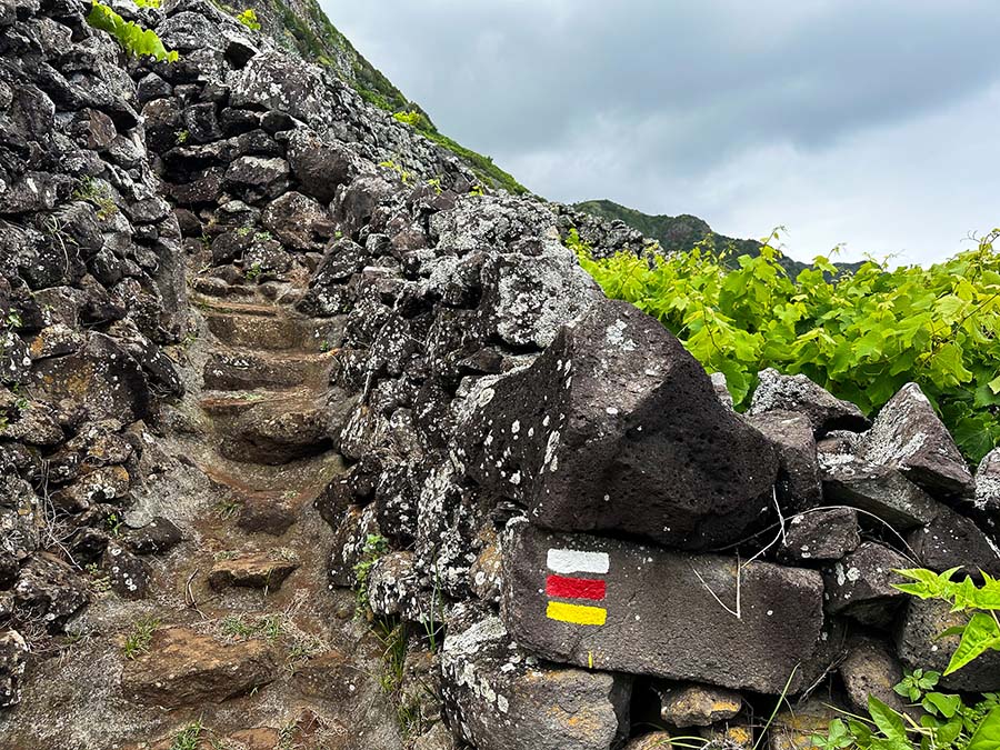
The Great Route of Santa Maria trek is a fairly new trek, as its inaugural year was only in 2015. The trail will continue to evolve, so always check in for any changes and modifications. Always follow the official trail markers of red, white, and oftentimes yellow blazes.
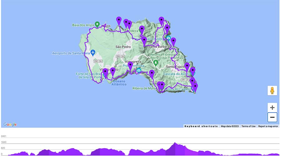

☛ Here’s the official Santa Maria Grand Route map from the Azores Tourism Board
Basic Overview | GR1 – Great Route of Santa Maria Trek
Disclaimer: There’s a chance this post contains affiliate links, and I receive a small (but grateful) portion of the sale. There’s no extra cost to you, and I only promote things that I use and love.
- Circular Trail
- The Trail circles the Azores island of Santa Maria from the main city of Vila do Porto
- Official Trail Name: Grand Route of Santa Maria (Great Route of Santa Maria, Grande Rota de Santa Maria)
- GR01SMA
- Trail Markers are found throughout the way but an offline map is extremely useful
- Look for official signboards and white and red blazes. Sometimes the blazes will be white, red, and yellow, which also indicates the trail is a marked day hike
- Difficulty: Challenging, due to the steep ascents and descents.
- Please don’t underestimate this trek
- Official Distance: 49 miles (78.6 KM)
- Excursion Duration: The Grand Route of Santa Maria Island takes 5 days / 4 nights if utilizing the Ilha a Pé shelters. This is the most convenient way to experience a multi-day hike in the Azores.
Hiking Stages Overview | Santa Maria Island Azores Trek
The official Grand Route of Santa Maria circular trek is known as the GR01 SMA. GR stands for Grande Rota in Portuguese. GR always coincides with a multi-day trek.
The circular route of Santa Maria officially reads 78.6 km (49 miles). The trail is marked with white, red, and yellow blazes. Be mindful that sometimes there are only red and yellow blazes, which typically indicate a day hike section of the trail.
Those utilizing the Ilha a Pé trekking hut system or using local taxis can walk the trek comfortably in 5 days.
Here’s what my 5 days of the Santa Maria trek looked like, using the Ilhe a Pé huts on the self-guided hut-to-hut trek in the Azores.
- Day 1 | Vila do Porto – Malbusca | 8 Miles / 13 KM | + / – 5 Hours
- Day 2 | Malbusca – Lapa | 10.75 Miles / 17.3 KM | + / – 7 Hours
- Day 3 | Lapa – Norte | 10.25 Miles / 16.5 KM | + / – 8 Hours
- Day 4 | Norte – Raposo | 7.65 Miles / 12.3 KM | + / – 6 Hours
- Day 5 | Raposo – Vila do Porto | 15 Miles / 24.1 KM | + / – 7.5 Hours
🥾 My personal mileage for the Grand Route of Santa Maria with some detours was 53 miles (85.3 KM)
Hikers who won’t be using the huts or using private accommodation along the way can divide the trek over 4 days around 20 Km each way. Remember, it is forbidden to wild camp, and not every village has places to sleep. There are taxi options to drive you to and from the trail sections.
- Day 1 | Vila do Porto – Cardal
- Day 2 | Cardal – Norte
- Day 3 | Norte – Bananeiras
- Day 4 | Bananeiras – Vila do Porto
Here are some of the Santa Maria accommodation options around the island if the huts are booked. There may be more options to sleep around the island, but verify with the Tourist Information Center. There’s a general tourist information office inside the airport, but it’s ideal to have accommodation arranged before starting the Great Route of Santa Maria.
That being said, I think the best way to hike around Santa Maria Island is using the Ilha a Pé accommodation shelters.
Book the Ilha a Pé Huts
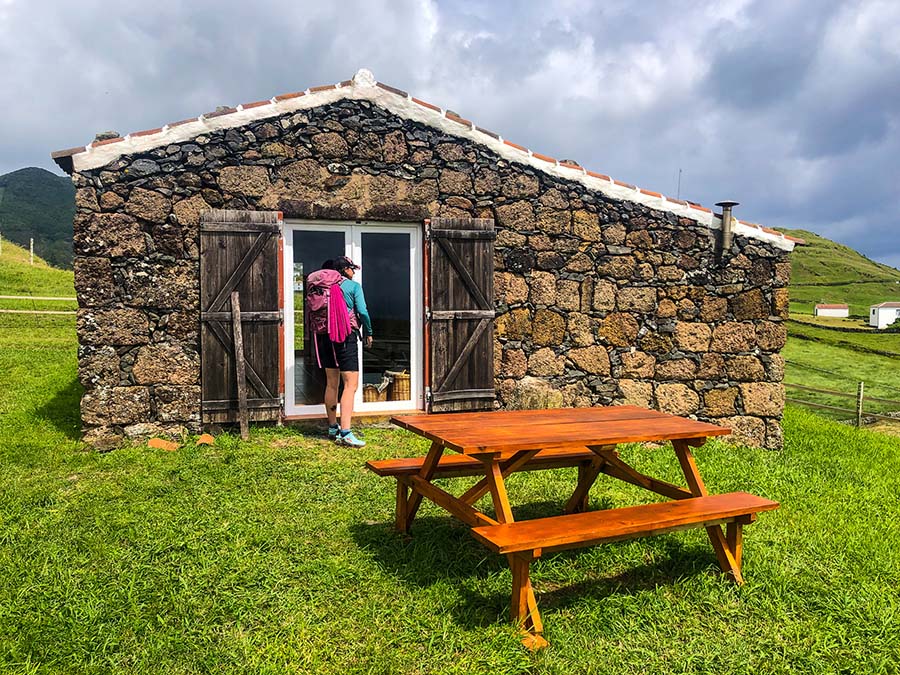
I trekked Santa Maria island using the stone huts that have been refurbished and given new life by Ilha a Pé. The local family has purchased four huts on Santa Maria Island and has created eco-huts that are a hiker’s dream.
Each hut has an indoor compost toilet, hot shower, wood stove, outdoor kitchen, and comfy beds. Staying in the traditional huts is an incredible experience.
Ioannis and Rita have put so much thought, effort, and care into these stone huts. They have seriously thought of everything! From shoe drying racks next to the wood-burning stove, to free-range chickens that eat scraps and provide eggs for the morning, and a clothesline, the shelters are well-thought-out by experienced hikers.
The modest shelters are cozy and lovely, and there is so much thought in design in each hut. The shelters are well-spaced around the island, making the self-guided trek flow with ease. This is by far one of the best hikes in the Azores.
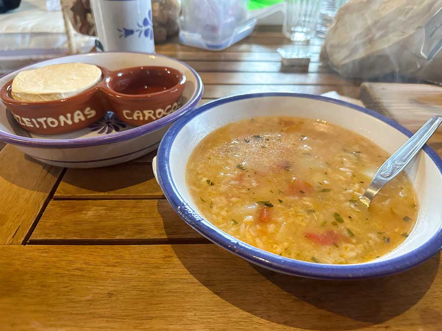
There are meal options available, luggage transfers, and the opportunity to rent gear.
If using the huts, bring your own quick-dry towel and sleeping bag to help cut down on costs. Sheets are provided and transported each day.
Those with meal plans can find it in a pot ready to heat on the stove. There are a few local restaurants on some days of the trek, but don’t count on them being open, especially in the off-season.
The huts sleep only four guests. It is possible to rent out the entire hut system as a private party.
Booking can only be done directly through the Ilha a Pe website. It’s best to book the shelters months in advance. For example, I hiked in mid-May, and I booked my space in February. There were only a few openings available.
The typical season for renting the Ilha a Pe huts is from April until November.
When booking the huts you are booking for all four nights. Simply pick the day you can start and request the booking. A confirmation e-mail will be sent with more details.
There is a down payment required to secure the booking. For those coming from the United States and outside Europe, an international wire transfer must be completed. I was able to complete this fairly easily with my local bank in Wisconsin.
How to Get to Santa Maria Island Azores

Santa Maria Island is south of the largest and most popular Azores Island, São Miguel. As of 2020, there are no ferries that connect São Miguel and Santa Maria islands.
It is only possible to book inter-island flights to Santa Maria from other Azores islands. SATA Airlines is the inter-island airline provider. If looking to visit a few islands, contact them directly and ask about the Azores Air Pass. These discounted tickets can only be purchased from a sales rep in person or on the phone. The Azores Air Pass is not available online.
The airport of Santa Maria Island is located close to the island’s largest city, Vila do Porto. This is where you can find the trailhead of the Great Route of Santa Maria.
The only way to reach the town is by walking (an hour) from the airport or by taking a taxi.
Taxi fares from Santa Maria Airport to Vila do Porto range around 10 Euros, depending on the time of day and how many passengers. The taxi fares are regulated, so make sure to check in with the tourist information center for the most up-to-date prices.
Sleeping in Vila do Porto

If planning on trekking the Great Route of Santa Maria, it’s ideal to spend at least a night in Vila do Porto. The city is small, and there are a few restaurants, wine bars, and, more importantly, grocery stores to stock up on snacks, food, and supplies.
- Pousada de Juventude de Santa Maria is a nice hostel found right next to the trailhead of the GR Santa Maria. Breakfast is included in the price, and they store valuables (for free).
- Charming Blue is a three-star hotel located right in the city center and is a popular place to stay in Vila do Porto.
- Casa da Avó is a private apartment located in the heart of Vila do Porto with extremely high ratings.
➜ Browse all the Places to Sleep in Vila do Porto
10 Tips for Walking the Great Route of Santa Maria Island

1 | Book the Ilha a Pé huts, you won’t regret it.
2 | Those utilizing the hut system by Ilha a Pé can cut costs by bringing a quick-dry towel and sleeping bag. However, Ilha a Pé does offer to rent sleeping bags, towels, hiking sticks, and other gear-related items.
3 | If booking through Ilha a Pé, it’s possible to have your luggage transported daily for an additional fee.
4 | It’s best to pack light, but still have enough gear. Be prepared for the weather to change fast and suddenly. Jump to my packing list here.
5 | Santa Maria is the southernmost Azores island, making it one of the warmest. However, the weather on the Azores islands can change in an instant. In just one hour, it’s possible to have the sun shining brightly, and then the Atlantic winds pick up and bring in a storm.
6 | Check to verify what restaurants and bars are open along the route. Many places close on certain days, especially in the off-season. I highly recommend the meal program through Ilha a Pé. The meals are hearty, filling, and worth it.
7 | Carry a lightweight reusable water bottle. The water at the huts is potable, and many of the beaches also have fresh water that is alright to drink.
8 | Have an offline map downloaded, like Maps.me. The trail is marked, but some sections could be marked more clearly. I referred to an offline map almost daily on the Santa Maria island trek.
9 | Bring a power bank to charge your electronic devices.
10 | Make sure to withdraw enough cash in Vila do Porto. If using the meal plan and the huts, there shouldn’t be a need to spend much. For example, at cafes, I had a coffee or purchased bread from the Artisan Bakery.
What to Pack for the Santa Maria Island Trek
Here’s a brief overview of my packing list for the Grand Route of Santa Maria trek.

Essential Items
✔ Medium-Sized Hiking Backpack – I carried my 36L Kyte Osprey Backpack, which is now discontinued. Similar backpacks include the 38L Kyte Osprey or the 33 L Osprey Tempest. This backpack is my go-to backpack for Europe and has been through the Picos de Europa in Spain and assisted me in walking multiple Camino de Santiago pilgrimage routes. I love this backpack for multi-day treks that require minimal gear.
✔ Sleeping Bag – I’ve recently switched over to a super lightweight sleeping bag, the Spark 45F Down Sleeping Bag – Women’s. This style of sleeping bag comes in a variety of temperatures.
I opted for the 45F since it can also double as a sleeping bag liner, all while offering a little more heat. I typically sleep cold. I am totally in love with this sleeping bag!
✔ Quick Dry Towel – Make sure to carry a lightweight quick-dry towel for after showers.
✔ Hiking Sticks can come in handy, especially since the trail has many ascents and descents. During rainy times, many sections of the trail can be quite muddy. Remember, if flying internationally, some airlines do not accept trekking poles in carry-on luggage.
✔ Natural Soap – The shower system in the huts uses a plant cleaning system, so it’s important to only bring natural shower products. I carry Dr. Bronner’s Liquid Soap (for hand-washing, laundry & shampoo) in a small reusable container.
For the Feet
✔ Proper Footwear depending on the season. I walked in May and loved my Altra Lone Peak trail runners. They dry quickly next to the fire and offer my feet enough support. Zero-drop shoes aren’t for everyone
If hiking during a season with lots of rain, it may be best to wear a hiking boot. Personally, I don’t use hiking boots anymore, but I recently purchased a GORE-TEX trail runner and La Sportiva Tx4 Approach shoes for off-season hiking.
Shoes are a personal preference and the most important decision when it comes to hiking
✔ Don’t forget to bring some kind of sandals or comfortable indoor shoes to wear around the shelter. I wore my classic Chaco Sandals.
✔ Merino wool socks help keep feet dry with moisture-wicking properties and allow for the foot to breathe. Carry a few different pairs, especially to swap out if your feet get wet throughout the day. I swap between the brands Smartwool and Darn Tough and use different cushion styles.

More Clothing Items
✔ Quick-Dry Shorts or durable Hiking Pants
I personally love these Women’s Dry on the Fly 7″ Shorts from Duluth Trading Company and prAna hiking pants. For a little thicker hiking pants, I prefer Duluth Trading Company’s Flexpedition Slim Leg Pants
✔ Buff for sun protection, along with a baseball cap
✔ Merino Smartwool long-sleeve Baselayer Shirt for sun protection and an extra layer
For warmer seasons, I like Smartwool Classic All-Season Merino Base Layer Long-Sleeve Top, but I also own thin merino wool tops from Tasc Performance and Icebreaker.
✔ A Quick Dry Hiking Top. I packed one REI Co-op Women’s Sahara T-Shirt and a REI Co-op Swiftland Running T-Shirt – Women’s
✔ Something comfortable to sleep in and wear around the huts after showering
✔ Warm fleece or a Merino Wool Sweater for at night
✔ Swimsuit for the many sandy beaches along the Santa Maria trek route if the weather permits
Miscellaneous Items
✔ If not utilizing the meal system, you will need to carry enough food for a day or two. All the huts have cutlery and dish sets, so no worry about carrying crockery.
✔ Lightweight Reusable Waterbottle I love my Hydro Flask Lightweight WaterBottle
✔ Chargers connect to a USB system and a provided solar charger (in the hut system)
✔ Headlamp
✔ Travel-size First-Aid Kit with basics like charcoal pills, an emergency blanket, and other useful items
✔ Almost all of the food waste is fed to the chickens (except for egg shells and citrus peels). However, there is so much food that you may wish to bring a reusable container to eat any leftovers for the following day. I like these Reusable Silicone Containers.
➯ Hey… don’t forget your Travel Insurance! I love SafetyWing
Santa Maria Circular Trek Itinerary by Day
Here’s what to expect when trekking the Great Route of Santa Maria in the Azores.
Skip to | Day 2 Malbusca – Lapa | Day 3 Lapa – Norte | Day 4 Norte – Raposo | Day 5 Raposo – Vila do Porto
Day 1 | Vila do Porto – Malbusca

Those hiking with Ilha a Pé will meet in the morning at their headquarters to have a quick briefing and receive an actual paper map of the Grand Route of Santa Maria trek. Ioannis and Rita are incredible hosts and offer up advice, luggage storage, and answer any other questions before departure.
Day 1 is the perfect introduction to the trek. Make sure to stock up on some snacks and last-minute supplies in Vila do Porto. There are two nice grocery stores with snacks and goodies near the center of town, Pongo Doce and Ângelo.
Once you take those first steps, it’s a completely self-guided journey to the beautiful island of Santa Maria.
The trailhead officially begins right next to the Forte de São Brás, the historical fortress in Vila do Porto. The trail is pretty straightforward; just make sure not to miss the turning point to head east and continue on the trail. Photo below.

One of the most memorable highlights of the first day is all the incredible views.
The trail passes by the Gruta do Figueiral, a manmade cave that was used to extract limestone.
The trail continues along the cliff and comes to a road. From here, there are two options to reach Praia Formosa. The longer, but more scenic version, walks along a secluded beach. Be mindful that this option is longer and steeper. I opted for the scenic version and took a quick dip in the ocean.
Always take caution if swimming on Santa Maria Island as there are currents and riptides, and many of the secluded beaches are unmanned. Swim at your own risk and don’t swim too far from shore.


The trail continues to the outskirts of Praia Formosa. There is a higher-end restaurant located on the beachfront, O Paquete. However, the GR-1 will take you up the hillside to the village of Malbusca. The uphill climb is quite grueling at the end of the day.
The Malbusca hut is located a little way from the main track. Each hut with Ilha a Pé is marked with signboards.
Overview Day 1 Great Route of Santa Maria Trek
- 8 Miles / 13 KM | + / – 5 Hours
Not Utilizing the Trek Huts?
There are a few private houses in and near Malbusca. Remember to have a local taxi number if staying in the outskirts.
- Casa Malbusca
- Cantinho do Paraiso (outskirts)
- Casa Bombordo (outskirts)
Day 2 | Malbusca – Lapa


Day 2 of the Santa Maria Island trek starts with a departure from town on the road. Shortly after, the trail leads into the scenic Barreiro da Piedade, a protected area of the Azores Geopark. The red soil is quite the contrast to the lush green hillsides.
The trail continues through a pasture uphill to a viewpoint. This section can be quite misleading, as it was not well marked, so check in with an offline map. The viewpoint is a small concrete structure, so just make sure to keep it in sight.
The views from the viewpoint are incredible, and the trail twists to the memorable Ribeira de Maloás waterfall. This unique waterfall flows over basalt lava flows that hardened into distinct prism columns. The waterfall is around 65 ft tall (20 m) and is part of the UNESCO Global Geopark.
The waterfall is surrounded by beautiful flora, and many frogs inhabit the area. Visiting Ribeira de Maloas kind of feels like stepping onto another planet or maybe like the film set of Jurassic Park.

The trail continues along the hillside and into lovely forests. Continue past the village of Cardal and see the first incredible views of the protected southeast corner of the island (Baia da Maia).
What probably catches your eye is the stunning lighthouse of Farol de Gonçalo Velho. The lighthouse is surrounded by ancient stone vineyards. The trail twists down the vineyards and leads to the road, where it’s possible to detour to the lighthouse. Be mindful that at the time of my visit (May 2023), the lighthouse was only open to tour on Wednesday afternoons.
From the lighthouse, there is also a steep downhill detour to an old Whaling Factory. If you don’t feel like walking down and back up again, there are nice views from the main road.
The trail continues to the stunning village of Maia. The trail literally follows through the steep trails of the stone vineyards. These sections are narrow and steep, so mind your footing.
Maia village has an enclosed swimming area in the sea but always take into consideration the weather. We didn’t swim as the wind was quite strong and conditions were not favorable.

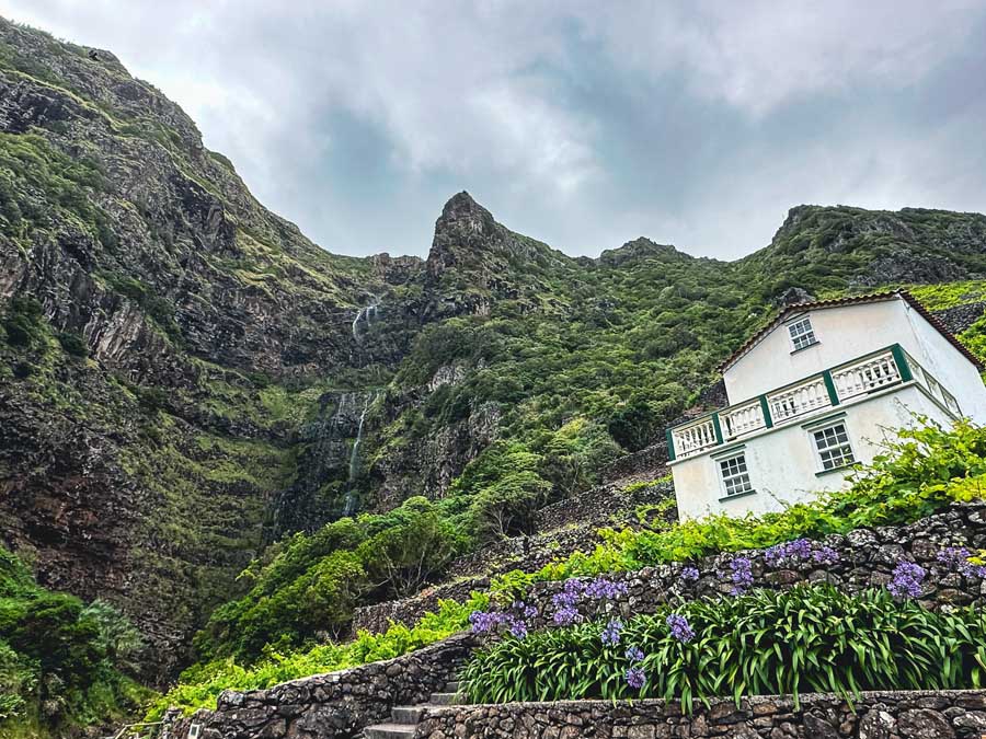
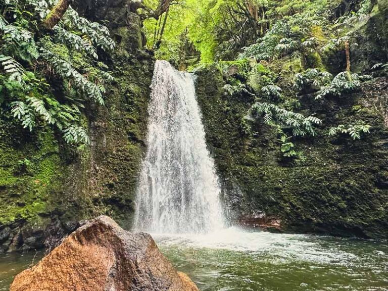
After Maia, take the opportunity to enjoy a picnic lunch at the base of Cascata do Aveiro, Portugal’s highest waterfall. Aveiro Waterfall towers at a scenic 361 feet (110 m).
After a quick break, head back to the village and catch the signposts up the stone-terraced vineyards. This section of the trail is steep but incredibly scenic and super fun! It was one of my favorite sections of the entire Grand Route of Santa Maria Island trek.
Again, sections of the trail are quite narrow. Soon, the trail will lead you toward the top of the Cascata do Aveiro. In fact, you’ll cross a bridge over the stream that feeds this waterfall.
The trail continues inland through a small forest. Eventually, the trail leads to the second cabin in Lapa.


Not Utilizing the Trek Huts?
You could continue further to sleep outside of Santo Espirito. It means adding on a few extra miles.
- Casa dos Valentes
- Casa da Avo (Turismo Rural) [outskirts of town]
Overview Day 2 Great Route of Santa Maria Trek
- 10.75 Miles / 17.3 KM | + / – 7 Hours
- Day 2 is one of the most scenic and diverse days of the Santa Maria Island Trek
Day 3 | Lapa – Norte
Day 3 of the Great Route of Santa Maria trek begins with a quick hike to the small village of Santo Espirito. There is a grocery store, a few bars, and the recommended cafe Brasil Tropical, which has one of the nicest owners! There is good WiFi, coffee, and snacks.
Santo Espirito also has a very worthwhile museum on the island. Unfortunately, it was closed on the day we visited, but a stop comes highly recommended.
Santo Espirito Museum | Find it here: Rua do Museu s/n -Santo Espírito | Summer Hours: Tues – Friday 10:00 – 17:30, closed on Monday | Official Website

Another highlight of Santo Espirito is visiting the homemade bakery. The bakery can be found behind the Artisan Weaving building on the outskirts of the village.
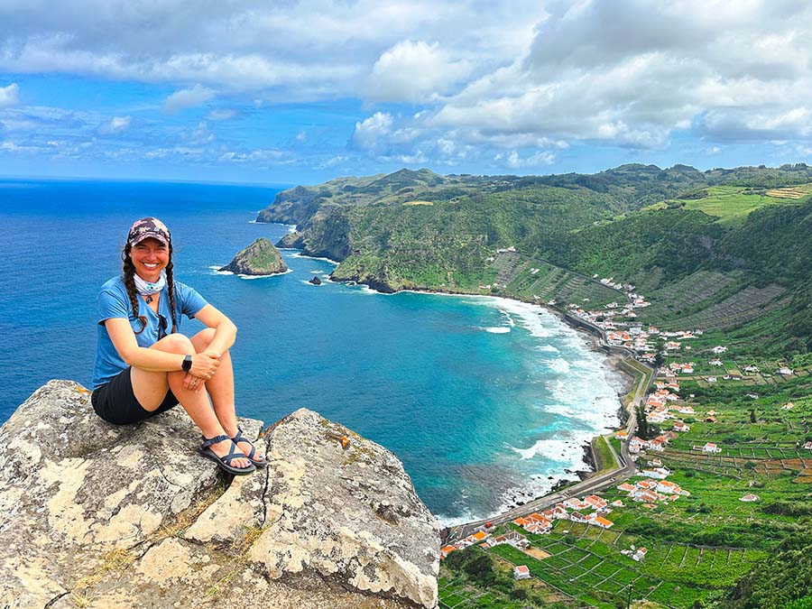
Return to town to find the trail that continues in the direction of São Lourenco. There is a lovely maintained viewpoint, the Miradouro de São Lourenço.
The trail continues through the hillsides and eventually comes to the main road. Follow the road until the path takes you to the beach area.

There is a really nice swimming area with WiFi and restrooms. There are a few bars and restaurants near the beach which may be open, depending on the day and season.
Again, the GR 01 Trail will continue uphill through the vineyards. There is a viewpoint at Miradouro do Barreiro, but I think the best views come from the short detour farther along the trail that overlooks Ponta do Matos.
The trail is a little off the main path, but extremely worthwhile! Be mindful that the lookout has no railings.
After, return to the Grand Route trail and continue past the Norte Lighthouse. The trail now continues past the stunning moss-covered cliffs of the northeast section of Santa Maria island.
The trail ends at the Norte Hut.


Not Utilizing the Trek Huts?
There are quite a few places to sleep in Norte if the huts are booked out.
Overview Day 3 Great Route of Santa Maria Trek
- 10.25 Miles / 16.5 KM | + / – 8 Hours
- Day 3 offers incredible views and is a highlight of the Santa Maria Island Trek
Day 4 | Norte – Raposo

The trail leaves Norte and leads to the scenic village of Santa Barbara. Again, Santa Barbara has a cafe and a small shop. It’s a great place to relax and keep an eye on the weather.
There are two routes from Santa Barbara. We were advised to take the PR 06 SMA in the direction of Praia Formosa. This route leads to Pico Alto, the tallest point on Santa Maria Island. This trail follows an uphill dirt path through a forest, consisting of towering cedar trees. This trail follows the red and yellow blazes.
There is an alternative path, but it is not advised to follow the trail. It is longer and along a main road.
There are typically clouds in the morning on Santa Maria Island. For this reason, try to wait out the weather in Santa Barbara before attempting the climb up Pico Alto.
We started the uphill climb after the clouds kind of parted, but we still encountered some heavy rain. We stopped in an enclosed section of the forest to wait out the rain. It moved out in about 15 minutes.
Take the short detour to the top of Pico Alto. This is Santa Maria’s tallest point at around 1,925 ft (587 m). You may have to wait a bit for the clouds to lift to get views of the entire island. While the views are lovely, it’s worth noting that there are many cell phone towers at the top, kind of taking away the natural elements here.


Follow the trail through the cedar forest. There is another short detour to a viewpoint that is also nice. On a super clear day, it’s been said it’s possible to see the south shore of São Miguel island.
The trail continues to the hut located in Raposo. The hut is truly stunning, so if you arrive at a decent time, drop off your bags and take the short but steep trail down to Baia do Raposo.
Baia do Raposo Visit
Baia do Raposo is a very small bay that, when the tide is right, has a small beach. The trail is marked but can be a little hard to follow as some sections are narrow and overgrown. The trail has a lot of short switchbacks.
The bay has a stream that dumps out into the Atlantic Ocean, creating a small trickle waterfall over the rocky cliffs. One of the coolest parts of this trail is that it passes by an old water mill. It’s also possible to see the unique stone wine terraces.

Honestly, the Baia do Raposo was one of my favorite sections of the Great Route of Santa Maria trek! If you have time, energy, and good weather, don’t miss the chance to visit the bay.
We stayed and enjoyed the bay for a good hour or so. We didn’t swim as the tide was strong, but we did enjoy splashing around in the freshwater stream, all while soaking our feet and savoring the views.
🥾 Detour to Baia Do Raposo (Round-Trip) | 1.25 Miles /2 KM | + / – 2 Hours
Not Utilizing the Trek Huts?
Continue onwards to Anjos Village, which means you’ll probably have to skip the detour to Baia Do Raposo.
- Casa dos Anjos
- Casa Aquário
Overview Day 4 Great Route of Santa Maria Trek
- 7.65 Miles / 12.3 KM | + / – 6 Hours
- Detour to Baia Do Raposo (Round-Trip) | 1.25 Miles /2 KM | + / – 2 Hours
Day 5 | Raposo – Vila do Porto
Sadly, Day 5 marks the last day of the Santa Maria trek. For me, Day 5 was one of the more challenging mental days of the trek as the path continues past the airport and is not as diverse as the rest of the days.
The trail starts through the forest and past the stream that dumps over the cliff to the Bay of Raposo. The next section leads through the Barreiro da Faneca, which is the red desert. There are a few viewpoints that offer views of where you came from and the sea.

After that, the trail follows near the coast to the village of Anjos. From here, the trail will continue until it reaches the west side of the island.
Some travelers may wish to walk to the airport and catch a taxi back to Vila do Porto. However, others may continue on the GR 01, which follows along the outside of the airport and telecommunication areas. This section lasts a few hours and is mostly flat with views of the west coast.
After the long straight stretch, the trail offers a chance to view the smaller island of Ilhéu da Vila. From there the trail continues and you’ll see where you started, the village of Vila do Porto.
Due to the port and other circumstances, the trail takes a long route inland back into Vila do Porto. This section feels like the absolute longest! However, the trail leads you right back to the main church plaza of the Church of Nossa Senhora da Vitória. From there, follow the road back to the fortress where you started.


The ending can seem a little anticlimactic. The trek is fairly new, so there is no ending KM marker, or anything like that, but still… the Great Route of Santa Maria Island is so worth it.
The Santa Maria island trek moved to the top of my list as one of the best multi-day treks in Europe.
Overview Day 5 Great Route of Santa Maria Trek
- 15 Miles / 24.1 KM | + / – 7.5 Hours
- Some trekkers may opt to follow the road into the airport to catch a taxi back to Vila do Porto, which would cut down the mileage for the final day by quite a bit
Grand Route of Santa Maria Trek Budget
So how much did the Great Route of Santa Maria personally cost me? Here’s my budget for the 5 days of trekking.
| Expense | Euros (€) |
| Ilha a Pé Huts (4 Nights with Meal Plan of Breakfast & Dinner) | €250 |
| Groceries (snacks before and during) | €14.50 |
| Cafe Stops | €5 |
| Bakery | €1.50 |
| Restaurant in Vila do Porto | €12 |
| Wine Shop | €3 |
| Total | €286 |
Trekking the Grand Route of Santa Maria in 5 days cost me around €286. My trek package with Ilha a Pe included meals, so I didn’t have to spend much on groceries and snacks. I also only ate at one restaurant on my arrival in Vila do Porto.
For the quality of the food and the portions, I found the meals to be well worth the price. The cabins by Ilha a Pé exceeded all of my expectations, and for the service and rustic luxury of the huts, I found this to be more than a fair price for this incredible trek.
I did end up staying a night before and after the trek in the Azores Youth Hostel of Santa Maria. The price is fair for the hostel and includes a simple breakfast, which also helps cut down on expenses.
I think the most convenient and enjoyable way to hike the Great Route of Santa Maria Island is to utilize the huts and meal services of Ilha a Pé.
More Places to See in the Azores Islands Portugal

Santa Maria island is only one of the nine Azores Islands. Each island is so different and offers plenty of things to see and do. There is no denying that hiking in the Azores is a highlight of the trip.
Most travelers traveling to the Azores only visit São Miguel Island, the biggest island. São Miguel is known for their stunning volcanic lakes, natural hot springs and thermal pools, and tea plantations.
São Miguel offers hiking trails like Salto do Cabrito, the water route of Janela do Inferno, and the beautiful Cascata Salto do Prego. There are many hiking trails on São Miguel Island.
The triangle islands of the Azores are Pico, São Jorge, and Faial.
Pico is known for being home to the tallest mountain in Portugal, Pico. Hiking Pico is often a bucket-list experience in the Azores. Pico Island is also blessed with unique vineyards and beautiful coastlines.
Faial has one of the busiest ports in the Azores. A nice place to savor the views is from Monte da Guia. The most famous hike in Faial is the Capelinhos Volcano, which has a detailed Interpretation Center. The Caldeira in the center of the island is protected, and the only way to visit the interior is on a guided tour. Another way to see the highlights is by hiking the challenging 10 Volcano trek.
Sāo Jorge may be one of the most underrated Azores islands. The island boasts beautiful fajãs. These unique landscapes are found at the foot of coastal cliffs and are formed by landslides or, in this case, more than likely lava flows. São Jorge is known for their cheese and offers opportunities to visit cheese factories, swim in natural pools, and hike along the spectacular fajās.

More Azores Online Resources
These resources can come in handy when planning a trip to the Azores.
- Official Tourism Website
- Azores Airlines
- Atlanticoline Ferry Transportation
- Spot Azores Live Weather Webcams
- Azores Hiking Trails by Island
Conclusion | Overview Great Route of Santa Maria Island
In short, this is a basic overview of the Great Route of Santa Maria Island trek. This guide includes a map, daily itinerary, packing list, and explains why it’s best to utilize the eco-friendly Ilha a Pé shelter system.
The Grand Route of Santa Maria is one of the best ways to see and experience the diversity of the underrated Santa Maria Island in the Azores. This trek was one of my absolute favorites of the Azores Islands, Portugal.
The trail is scenic and circles the entire island of Santa Maria. Expect to be blown away by stunning views, beautiful beaches, unique landscapes, waterfalls, lighthouses, ancient stone terraces, and a climb up the tallest mountains of the island.
The Santa Maria island trek will be a highlight of visiting the Azores islands of Portugal.
Have you hiked the Great Route of Santa Maria? What did you think? Are there any updates you can add to this trekking guide?
Pack This Post for Later! Pin It!


Disclaimer: There’s a chance this post contains affiliate links, and I receive a small (but grateful) portion of the sale. There’s no extra cost to you, and I only promote things that I use and love.