Hiking Guide to the Strenuous Ten Volcanoes Trail Faial Azores
One of the toughest hikes I completed on the Azores was on the island of Faial. The Route of the Ten Volcanoes starts from the Caldeira of Faial and ends at the Capelinhos volcano. The route gets its name from the ten volcanoes you see while hiking.
This strenuous hiking trail provides incredible views of the many volcanoes. The hike starts with sweeping views of one of the more unique craters found throughout the Azores. The trail passes through scenic protected areas and towering cedar forests. Another highlight is a stroll along water canals.
If you are looking to do only one hike on Faial Island, this is it. It covers many of the highlights from Caldeira to Capelinhos and the eight volcanoes between it.
This is a basic hiking guide to the Ten Volcanoes trail with helpful hiking tips.
Table of Contents
Disclosure: This is part of my Hikes & Adventures series, which means these treks can be strenuous and challenging. These are my experiences and I am not an expert. Please have all the proper equipment, verify the weather conditions, use professional resources, do your own research, be mindful of constantly changing trail conditions, and take into consideration your own physical abilities and/or limitations. These guides are for entertainment purposes only. Please see my full disclosure for more information here.
- The Route of Ten Volcanoes (Rota dos Dez Vulcões) Overview | PR 06 FAI
- What to Pack for The Ten Volcanoes Day Hike
- How to Reach the Rota dos Dez Vulcões Trailhead
- The Challenging Ten Volcanoes Trail
- Visit Capelinhos Volcano Interpretation Center
- How to Return to Horta Faial
- Tips for Hiking the Rota dos Dez Vulcões on Faial
- Ten Volcanoes Hiking Tours & Alternative Faial Tour Options
- Conclusion | Ten Volcanoes Hiking Guide
Route of Ten Volcanoes (Rota dos Dez Vulcões) Overview | PR 06 FAI

- Point to Point Trail | Rota dos Dez Vulcões | PR 06 FAI
- Trailhead: Caldeira of Faial
- End Point: Capelinhos Volcano Interpretation Centre
- Official Trail Markers: PR 06 FAI is marked with yellow and red wooden signboards and blazes found throughout the trail. There are also official signboards found at some segments
- Difficulty: Hard
- Official Trail Distance: 12 Miles (19.3 Km)
- Excursion Duration: At least 5 hours, dependent on weather, stops, speed, etc
- It took me almost 6 hours with no breaks
- Azores Trails has a downloadable version of the Rota dos Dez Vulcões here
The Route of the Ten Volcanoes is challenging. The driver who took me to the trailhead told me this trek was as tough as Pico Mountain and I understood what he was saying when I finished. Do not underestimate this route as it is strenuous with plenty of ascents and descents.
The Route of Ten Volcanoes Map

Ten Volcanoes Day Hike Packing List
For any day hike on the Azores, it’s ideal to have a well-stocked day pack. The Rota dos Dez Vulcões is a LONG day, so plenty of food and water are essential. Like all Azores islands, the weather can change fast on Faial and is unpredictable. Make sure to carry extra dry gear, a rain jacket, and plenty of snacks and water.
🎒 For day hikes on the Azores, I used the Sea to Summit Ultra-Sil Travel Day Pack which fits easily inside my Osprey Kyte 36. The Osprey Day Pack Plus is an awesome day pack for those travelers not backpacking through Europe.
⁉️ On every single day hike, I never leave without a First-Aid Kit that has at least one emergency blanket in it. As I referred to an offline map quite a bit on this hike, a fully charged power bank was also essential.

🚰 I carry a lightweight Hydra Flask Water Bottle that holds at least 1.5 L of water. However, for this hike, I wish I had carried more. Carry extra water as there are no refill spigots along the trail.
👣 Trekking Poles are useful, especially on muddy trails. There are lots of ascents and descents on this trail, so hiking poles make sense.
🥾 I visited the Azores at the end of May and beginning of June and found that my Altra Trail runners were perfect and dried quickly. If looking for more ankle support, try Salomon trail runners. Some people prefer hiking boots.
🧦 Carry a lightweight packable rain jacket. For sun protection and chilly mornings, a Smartwool All-Season Merino Base Layer Long-Sleevelong Shirt is great. Additionally, a baseball cap or a buff works to cover your face for sun protection. An extra pair of Merino wool socks is amazing to change into mid-hike if the ones on your feet get wet.
⌚️ An Apple Watch is great for recording hiking trails and check-in with daily fitness goals
💶 Euros for taxis and entrance to Capelinhos Volcano Interpretation Center.
➯ Hey… don’t forget your Travel Insurance! I love SafetyWing
How to Get to the Rota dos Dez Vulcões Trailhead

The Rota dos Dez Vulcões trailhead is found near the top of the Caldeira of Faial. The trek starts by circling part of the crater.
If you have a car, there is a small parking lot here. Parking is free and on a first come first serve basis. Just remember that you will need to find a ride back to your car as the trail ends on the west side of Faial Island.
Most travelers will sleep in Horta to explore Faial. Numerous tourist agencies take tours to the Caldeira, so you can ask to pay for a seat if there is room.
Additionally, taxis run between Horta and the Caldeira. Make sure to verify the current price list. All the Azores islands have set prices for taxis.
☛ I organized a ride with the tour agency Walk-In-Blue. The company is run by a local who focuses on sustainable tourism. I was dropped off at the trailhead early (around 7 am). Make sure to arrange a pick-up to return to your hotel or rental car. The cost was similar to a taxi at 25 Euros.
The Challenging Ten Volcanoes Trail

One thing to check in on before starting this trail is the weather. Oftentimes the Caldeira can be covered in clouds and rain. Although I started in the clouds, the weather changed as soon as I left the Caldeira, and was sunny and hot.
Never start this trek during bad weather.
It’s also worth noting that sections of this trail are quite remote. While you may see some hikers around the Caldeira, I saw no one on the trail until I got closer to the Capelinhos volcano. The trail sections were very quiet.
Trailhead Around the Caldeira of Faial
Again, I started with foggy conditions but chose to continue along the crater rim. Be mindful that you can not walk into the crater at all unless with a guided tour. The Caldeira of Faial is a protected natural park and has a few cones and lakes in the center. It is spectacular, even on a misty day.
The signboards direct hikers to the right, past the small chapel. There are supposed views of Graciosa Island in the distance, but it was pretty foggy.
The trail around this Caldeira of Faial is around 3,000 ft. The Ten Volcanoes hike highest point is along the crater around 3,040 ft (927 m).

Just before I was ready to depart the section around the Caldeira I saw a small break and could see inside the crater. It is quite unique as it is green and full of life.
I stopped and admired the mist-covered crater view and stayed longer than expected.
There are signboards where the trail splits to follow the Ten Volcanoes trail. They are marked with Dez Vulcões with red and yellow blazes. Be mindful that from the Caldeira the Faial from Coast to Coast (Faial Costa a Costa – Faial Great Route marked in White and Red Blazes) merges and follows the Ten Volcanoes trail.
🥾 Dez Vulcões Trailhead – Caldeira signboard | Distance: 2.5 Miles | Duration: +/ – 1 hour and a half
Caldeira Trail Split – Tanque de Agua da Levada


Take the small trail down to the gravel road. Follow the road surrounded on each side by beautiful Laurel forest. Soon the blazes will lead to a water canal (levada). This section of the trail will be a gradual ascent and on a trail.
Although it does not showcase the volcanoes, this was one of my favorite sections of the trail. Maybe, it was because it reminded me of a few of the forest sections on the Santa Maria Island Grand Route I trekked a week earlier.
Laurel forests are temperate evergreen forests that are found where there is high humidity and mild temperatures, creating almost like a subtropical cloud forest. They are pure magic. Also, the fog was lifting so I started to see the panoramic views of the island.
The Faial water canal was completed in 1964 and at its time was an engineering marvel. The water canal was over 6 miles long.
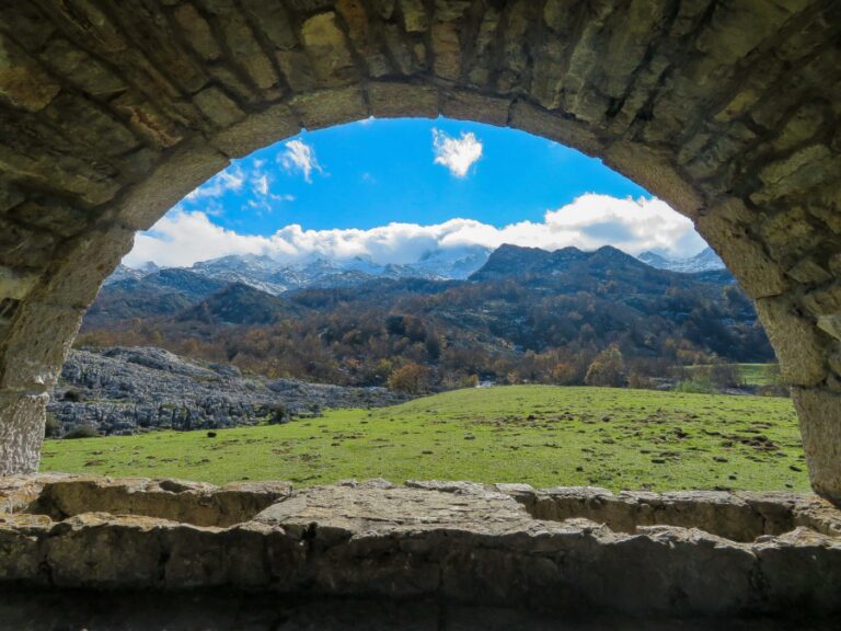
Cross over a wooden bridge and follow the water canal. When the forest breaks, you’ll see the first views of the cone-shaped volcanoes. As you continue on the Ten Volcanoes trail, these views only become more incredible.
The trail leads to the Tanue de Agua da Levada, or the water reservoir tank.
There is a signboard near the end of the tank to continue on the Levada trail (PR 03 FAI) or the Dez Vulcões (PR 06 FAI). Continue to the Ten Volcanoes trail.
🥾 Caldeira Signboard – Tanque de Agua da Levada | Distance: 2.75 Miles | Duration: + 1 hour
Tanque de Áqua da Levada – Parque Florestal do Capelo

The next section of the Ten Volcanoes trail continues to the Protected Area of Cabeco dó Fogo. This area had a major eruption that started on April 24, 1672 and continued for almost a year.
The villages of Ribera Brava and Praia do Norte were destroyed and sadly many lives were lost.
This area is protected since the vegetation is raw and the island is trying to keep it preserved in its natural state.
Appreciate the young landscapes, where you’ll see views of the Ocean and Ponta do Morro – Castelo Branco.
The trail continues past the Casa das Lavadeiras, which are old washing houses. The actual translation is House of the Washerwomen. These public washing facilities were used for the majority of the 19th century.


Follow the trail to Parque Florestal do Capelo, which has an old typical house, restrooms, and a water fountain to replenish water supplies. There are also a few picnic benches, making it an ideal place to take a break.
🥾 Tanque de Áqua da Levada – Parque Florestal do Capelo | Distance: 3.25 Miles | Duration: +/ – 1.5 hours
Parque Florestal do Capelo – Capelinhos Volcano Interpretation Centre
After the park, the trail continues to provide challenges to the Capelinhos Volcano Interpretation Center and Lighthouse. There are some steep ascents and descents, especially as the distance is long. At the park, the hike is about 8.5 miles (13.7 km), which means there are still almost 4 miles to go.
There is a lot less forest coverage and the trail becomes more exposed. The little ascents and descents you can feel, especially as the afternoon heat approaches.


The trail continues through fields and the outskirts of Cruzeiro village. There is less signage here, so it’s good to check in with an offline map.
There is a main signboard further up that will lead you past the Furn Ruim, a cave. There are views of Cabeço do Canto cone and the first barren views of Capelinhos. Walk along the slopes of Miradouro Caldeirão, which is covered in the native vegetation.
Perhaps my favorite section was looking back at where I had walked from and seeing the craters of the volcanoes in the distance.
Follow along the Cabeço do Canto volcano and follow the steps down past the Cave of Cabeço do Canto. The final stretch of vegetation takes you to a Whale Lookout. This is one final viewpoint of the green and fertile landscapes of the Ten Volcanoes trail.
Shortly after the Whale Lookout, cross the highway. Be careful here as the road can be busy. Leave the vegetation of the volcanic slopes and enter the barren landscapes of Capelinhos.

Capelinhos Volcano erupted in 1957 and 1958, so this is one of the youngest landscapes of the Azores islands.
The trail continues to the Lighthouse of Ponta dos Capelinhos and the Capelinhos Volcano Interpretation Center.
🥾 My Personal Ten Volcanoes Hike Stats | Distance: 12.65 Miles (20.35 KM) | Duration: 6 hours
Visit Capelinhos Volcano Interpretation Center

There are some trails to explore this unique landscape, but be mindful to always stay on the trails. After my full hiking day, I felt pretty exhausted, so only walked around the lighthouse and the trail section that led to the Interpretation Center.
The Capelinhos Volcano Interpretation Center can be visited for a fee. It is built underground so that it does not affect the landscapes of the protected area.
🥾 Capelinhos Volcano Interpretation Centre | Admission Ticket: €10 | Hours: Vary by Season
Besides the Capelinhos Volcano Interpretation Center, there is a road that leads to Casa dos Botes, a museum that showcases the old whaling village that was destroyed by the Capelinhos eruption.
There is also a natural swimming area that boasts views of Capelinhos, but always be mindful of the tides and weather conditions when swimming in the Azores.
How to Return to Horta Faial

There is one bus that runs from Capelihos Volcano Interpretation Center, but unfortunately, the hike took me longer than I expected and I missed it. Again, don’t underestimate the Ten Volcanoes trail on Faial!
It’s best to arrange a pick-up from a taxi driver before starting out. I did stop at the Interpretation Center and was greeted by a friendly guy at reception who offered the number of a taxi driver.
I resorted to hitch-hiking, but I wouldn’t rely on this method. The road is frequented mostly by tourists, so it depends on if you can find someone heading back to Horta. I was lucky to be picked up by a lovely family from France.
Horta is a bustling port town and is quite picturesque. One of the best views of Horta comes from the protected landscape of Monte da Guia.
Horta is where most visitors choose to sleep. Horta offers numerous places to stay for every type of budget. This is where most visitors stay when visiting Faial Island. I loved sleeping at Largo Bispo Boutique Hostel.
Faial is part of the “triangle islands” of the Azores. There are numerous ferries between Pico Island and São Jorge Island, so some travelers only visit Faial Island as a day trip. However, if planning on hiking the Ten Volcanoes trail, I recommend sleeping on the island in Horta.
Tips for Hiking the Rota dos Dez Vulcões on Faial

The Ten Volcanoes hike is pretty straightforward, but it is challenging. These are some useful tips for completing one of the toughest Azores hiking trails.
Be Mindful of the Weather
The Azores are found in the middle of the Atlantic Ocean and the weather can change drastically in just a short time. Faial is known as the “Blue Island” for all the hydrangeas found throughout the island.
Like all the Azores Islands, the weather can change in a heartbeat. It’s best to be prepared for the weather conditions to change drastically.
The Caldeira of Faial can be covered in fog in the early morning, but clear by the afternoon. However, on some days the island can stay covered in fog. Never start hiking the Ten Volcanoes trail during bad weather as the trail is hard.
It’s nice to check the SpotAzores webcams found throughout all nine of the islands. Faial has a camera on Horta and at the Caldeira. Do not rely on the cameras since the weather can change at a moment’s notice.
Carry Enough Water & Proper Gear
A day hike pack is essential for the Ten Volcanoes hike. There is only one place to refill water at the Parque Florestal do Capelo. It is not good to rely on the fountains. I suggest carrying at least 2 liters of water for this challenging trek.
Another problem I ran into was a lack of services. There isn’t a cafe or market on the actual trail. It’s a small detour to get food, so pack snacks and something hearty to eat. I found myself extremely hungry after this hike.
Carry gear to protect from the intense afternoon sun. There is little shade coverage after you pass the water reservoir. I started the hike in a rain jacket and a Buff to shield myself from the wind at the Caldeira and then layered to protect myself from the sun by the time I reached Capelinhos.
Be Up to Date on Current Trail Conditions
Always check in with the official Tourist Information Center about trail closures on the Azores. While this is less of an issue on Faial Island, never hike on closed trails.
Do I Need a Guide to Hike Rota dos Dez Vulcões?
No, a guide is not required to hike the Ten Volcanoes trail. However, this is a long and challenging day hike. A guide may help alleviate any anxiety about hiking this trail.
All of the official hiking trails across every Azore island are registered, well-marked, and have detailed trail information and pamphlets. So, if you’re a confident hiker, no guide is needed.
The island of Faial has 10 registered hiking trails, with the Rota dos Dez Vulcões being a registered day hike. Always check the current trail conditions.
Ten Volcanoes Hiking Tours & Alternative Faial Tour Options

Most travelers sleep in Horta on Faial Island and can walk through the town to check out some local tour options.
These are some Ten Volcanoes hiking tours and other ways to experience Faial Island.
➜ This is a highly rated 10 Volcanos Hiking Private Tour
➜ The Caldeira of Faial is a protected landscape, so if looking to hike into the Caldeira do Faial you need to book a Guided Descent Tour.
➜ If you don’t want to hike but still experience the best of Faial Island, Book a Full Day Tour – Faial Island
Conclusion | Ten Volcanoes Hiking Guide
In short, this is a quick overview of the epic Ten Volcanoes hike on Faial Island of the Azores. This strenuous day hike showcases the Caldeira of Faial, laurel forests, water canals, and a total of ten volcanoes. The grand finale is the Capelinhos Volcano, which is one of the youngest landscapes of the Azores islands.
The Rota dos Dez Vulcões trail is challenging, but one of the most rewarding hikes in the Azores.
Did you hike the Ten Volcanoes trail on Faial Island? What did you think? Any updates I should know about? Let me know in the comments below!
Pack This Post for Later! Pin It!

Disclaimer: There’s a chance this post contains affiliate links, and I receive a small (but grateful) portion of the sale. There’s no extra cost to you, and I only promote things that I use and love.