9 Awesome Hikes in the Azores | The Best Hike on Every Island
The Azores are nine volcanic islands in the middle of the Atlantic Ocean and make a wonderful destination for hikers. Each island has its own personality and this post highlights the best hikes in the Azores by island.
This diverse archipelago sits between the United States and Portugal and boasts crater lakes, hot springs, waterfalls, and some out-of-this-world landscapes. One day you may find yourself climbing Portugal’s tallest mountain and the next walking through an ancient Laurel forest. These are the rewards of hiking in the Azores.
This hiking guide includes the best hikes in the Azores, tips on how to reach each trailhead, useful advice for hiking in the Azores, and a general packing list for those planning a hiking trip to the Azores Portugal.
Here are the 9 best hikes in the Azores for each island.
Table of Contents
Disclosure: This is part of my Hikes & Adventures series, which means these treks can be strenuous and challenging. These are my experiences and I am not an expert. Please have all the proper equipment, verify the weather conditions, use professional resources, do your own research, be mindful of constantly changing trail conditions, and take into consideration your own physical abilities and/or limitations. These guides are for entertainment purposes only. Please see my full disclosure for more information here.
- Overview of the Hiking Trails in the Azores
- The 9 Best Hiking Trails on the Azores Islands
- General Hiking Tips for the Azores Islands
- Packing List for Hiking in the Azores
- Conclusion | Best Hikes in the Azores, One Hike for Every Island
Overview of the Hiking Trails in the Azores

The nine Azores Islands are an autonomous region of Portugal and are divided into 3 main groups: Eastern, Central, and Western
- Eastern Group: São Miguel Island & Santa Maria Island
- Central Group: Terceira Island, Pico Island, Faial Island, São Jorge Island, & Graciosa Island
- Western Group: Flores Island & Corvo Island
The Azores islands are an eco-destination and have done an excellent job maintaining and mapping out numerous hiking trails. Each island has officially registered trails either marked as a PR or GR trail.
PR translates to Pequena Rota, or small route, and are ideally day hikes. Azores day hikes can be point-to-point or loop trails.
GR are Grande Rota, or grand route, and are multi-day treks. Be mindful that wild camping is prohibited in the Azores. Camping is allowed at designated locations. There are also numerous local lodging options available, but should be reserved in advance.

Across the nine Azores islands, there are at least 85 PR trails and 7 Grand Routes. Additionally, there are local trails (trilhos) run by municipalities of the islands. As you can see there is no shortage of epic hikes in the Azores.
I spent over three weeks hiking in Azores on five islands. To help complete this best hiking trails in the Azores, I’ve called in travel bloggers with expertise in the Azores to collaborate on this post.
9 Best Hikes in the Azores by Island
Here are the best nine hikes in the Azores for each Island.
1 | São Miguel Island | Salto do Prego – Sanguinho – PRC 09 SMI
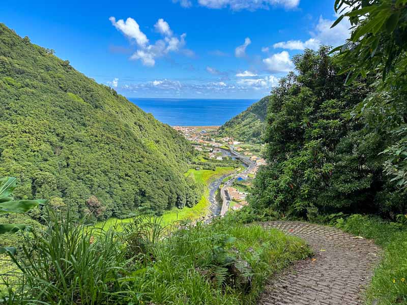
São Miguel is the largest Azores Island and has the best infrastructure, resulting in it being the most visited Azores island. São Miguel has 30 officially registered PR hiking trails.
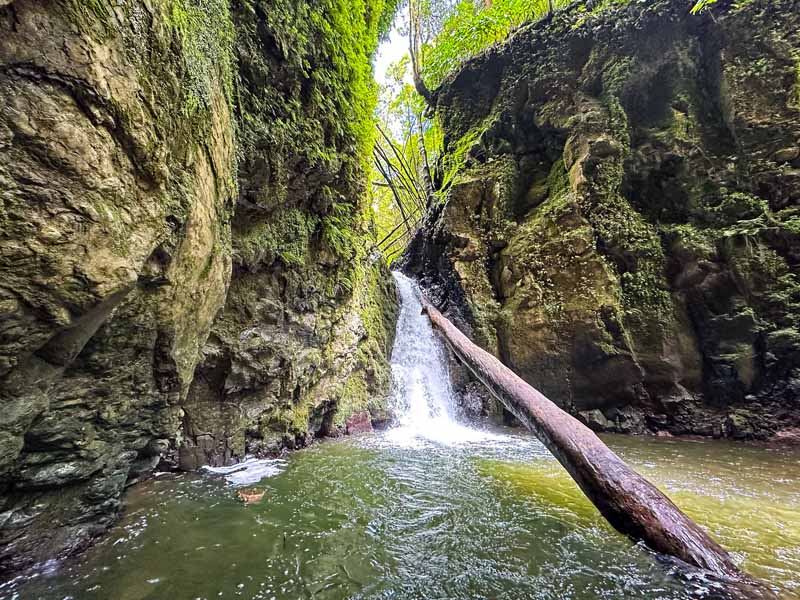
With so many incredible hiking trails in São Miguel, if you only have time for one hike, make it the Salto do Prego – Sanguinho trail. This hiking trail boasts two waterfalls and the hilltop almost forgotten village of Sanguinho. The forest sections of the trails are also unforgettable.
Located on the east side of São Miguel, this trail begins in the village of Faial da Terra. Follow the trail to the stunning Salto do Prego waterfall. Do take the detour to the waterfall of Salto do Cagarrão, an equally impressive waterfall. Either way, the loop trail takes hikers to the village of Sanguinho.
On a hot sunny day, both waterfalls offer a chance to swim at the base of the falls. The trail boasts many scenic viewpoints, forest trails, and the small hamlet of Sanguinho. During the summer months, enjoy a beverage at the lone bar in Sanguinho.
The trail is a loop from Faial da Terra and is relatively moderate. Adding the second Cagarrão makes the hiking trail more challenging.
🥾 Salto do Prego Sanguinho Trail Logistics
- Trail Number: PRC 09 SMI (with Salto do Cagarrão Detour on PR 11 SMI)
- Loop Trail
- Distance: Around 5.5 miles (8.85 Km) for both waterfalls
- Duration: +/- 4 hours depending on swimming and stops
- Difficulty: Moderate, (More challenging if adding the Cagarrão Waterfall)
- Official Salto do Prego Sanguinho Hiking Map
How to Reach the Trailhead for Salto do Prego Sanguinho
Hikers will have to start this hiking trail from Faial da Terra on the east side of São Miguel island.
🚗 Most hikers will sleep in Ponta Delgada, making a car essential for reaching the trailhead at Salto do Prego Sanguinho. Find ample spaces to park on the road on R. do Burguete. Parking is free and on a first come first serve basis.
🚌 Buses are nearly impossible to use to reach the Salto do Prego trailhead if basing in Ponta Delgada. There is a bus to Povoacao from Ponta Delgada, but the walk to reach the trailhead in Faial da Terra requires at least 3 hours.
This is a popular hiking tour of Salto do Prego and Povoacao. Another top-rated Full Day Hiking Faial da Terra tour includes both Prego and Cagarrão Waterfalls.
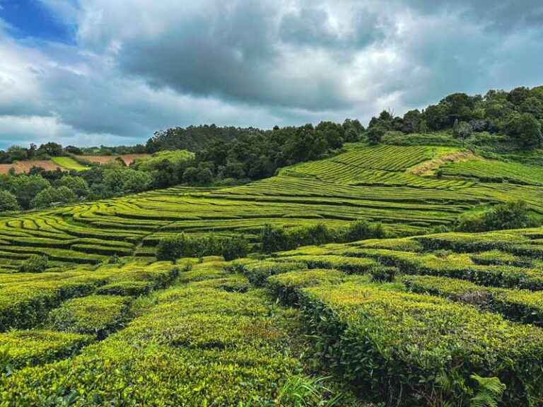
Psst.. Want some more hiking ideas for São Miguel? The Janela do Inferno is a spectacular trail with old water tunnels and a moss-covered aqueduct. Another popular trail in the Salto do Cabrito trail offers a chance to soak in local hot springs. The Gorreana Tea Factory has tea fields that are a delight to stroll. Perhaps the most photographed places in São Miguel are the crater lake views of Sete Cidades and Lagoa do Fogo.
2 | Santa Maria Island | Great Route of Santa Maria GR01SMA


Santa Maria Island is the oldest Azores island with many of the geological formations dating to almost 8 million years old. By far the Great Route of Santa Maria is my favorite hike in the Azores, an epic adventure that spans over five days.
The Grand Route of Santa Maria is so diverse and offers the opportunity to walk beside unique landscapes, swim at sandy beaches, and savor views from the base of one of Portugal’s tallest waterfalls. Perhaps my favorite thing about this multi-day trek is the chance to walk through the old stone wine terraces.
From the shores of the island to the tallest point (Pico Alto) the circular route of Santa Maria is a hiker’s dream.
Another highlight of the Great Route of Santa Maria is the chance to hike through tiny villages. Many of the hamlets have artisan goods from bread to hand-woven treasures. This is one of the least visited islands, so it feels untouched, almost as if you’re stepping back in time.
The best way to hike the Great Route of Santa Maria is to utilize the incredible hut system by Ilha a Pe. The four traditional huts are strategically placed along the route and offer everything you could need to complete the trek independently. Ilha a Pe also offers hearty traditional meals and the opportunity to rent equipment for the trek.

🥾 Grand Route of Santa Maria Trail Logistics
- Trail Number: GR01SMA
- Loop Trail
- Distance: 49 miles (78.6 Km)
- Duration: 5 days with Ilha a Pe huts / 4 – 5 days with local lodging
- Difficulty: Moderate
- Official Grand Route of Santa Maria Hiking Map
How to Reach the Grand Route of Santa Maria Trailhead
The Santa Maria Grand Route trek begins near the main village of Vila do Porto. It’s best to sleep in Vila do Porto the night before departing on the trek.
The airport is close to Vila do Porto and it’s easy to grab a taxi to all the accommodation options.
Pousada de Juventude de Santa Maria is a simple hostel located steps away from the trailhead with free breakfast and will stow valuables.
3 | Terceira Island | Monte Brasil | PRC04 TER

Submitted by Ada of Beyond the Yellow Brick Road: A Travel Blog
If you’re headed to Terceira Island, chances are you’re planning to visit Angra do Heroismo, the oldest city in the Azores. While you’re visiting Angra – which is a UNESCO World Heritage site –be sure to hike up Monte Brasil, an extinct volcano on a peninsula that juts out from the city center.
This urban hike uses paved roads, wide gravel trails, and stairs to get you to the top of Monte Brasil. The only real challenge this trail poses is the initial uphill climb. Once you’re at the top, the path winds peacefully through thick woods and offers views of the historic city below, the Atlantic Ocean, and the extinct volcano’s caldera.
Monte Brasil highlights include the Miradouro do Pico das Cruzinhas, where you get a sweeping of Angra do Heroismo and the city marina, and an abandoned whaling station. Don’t miss the cat colony where sleepy kitties emerge from their enclosures for head scratches. There’s also a small enclosure on the way up with a few exotic birds like peacocks.
The base of Monte Brasil is dominated by the formidable Fortress of Sao Joao Baptista.
Amenities on Monte Brasil include public toilets (but be prepared with your own toilet paper and hand sanitizer), and picnic areas.
🥾 Monte Brasil Trail Logistics
- Trail Number: PRC04 TER
- Loop Trail
- Distance: 4.6 miles (7.4 Km)
- Duration: + 2 hours depending on photos and breaks
- Difficulty: Easy – Moderate
- Official Monte Brasil Hiking Map
How to Reach Monte Brasil Trailhead
If you’re staying in Angra do Heroismo, you can easily hike to the trailhead from anywhere in the historic city center.
🚗 There are two parking lots you can use at the base of Monte Brasil.
🚲 Another unique way to experience Monte Brasil is via this E-Bike tour.
4 | Pico Island | Pico Mountain Trail

Pico Mountain is what inspired me to visit the Azores islands. Mount Pico is Portugal’s tallest mountain sitting at an impressive 7,713 ft (2,351 m). This stratovolcano comprises of basalt and is one of the most challenging hikes in the Azores.
Pico Mountain is part of the Protected Pico Nature Park, so a permit is required to climb Pico. It is possible to hike up Pico without a guide, but with constantly changing weather conditions and tough terrain, hiring a guide is highly recommended. This is especially true for those who don’t feel comfortable trekking and carrying the proper gear.
Pico Mountain Trail follows 47 wooden markers up the stratovolcano. The weather can change fast, so these useful markers work as a guide up the mountainside. Upon completion of Pico Mountain, you will be rewarded a completion certificate at the Casa da Montanha.
If hiking Pico Mountain Trail without a guide, make sure to reserve a spot. The Pico trail maxes out at 320 visitors per day. Do add “Piquinho,” the small peak inside the crater that boasts panoramic views of Pico Island and makes for an ideal spot to watch the sunset or the sunrise.
Those craving those colorful views from Pico should arrange to camp inside the crater. Camping permits are limited to 32 visitors a day. If camping at Pico Mountain you will have to carry the proper gear and enough water as there is no place to obtain water on the trail.

Casa da Montanha
All hikers must access the trail from the Casa da Montanha (Mountain House). The Casa da Montanha sits at an elevation of 3,937 ft (1,200 m), making the climb up Mount Pico much more feasible. Casa da Montanha has restrooms and a small bar/restaurant.
All hikers looking to trek up Mount Pico must utilize a guide or have a prearranged permit by date and time.
A guide comes highly recommended to hike the Pico Mountain Trail. This is the official list of Pico Mountain Guides. Be mindful that during the peak summer months many of the guides are booked out far in advance.
Independent hikers must check in at the Mountain House where you are given a GPS tracker and overview of the hike. If you wander off the main path they will radio you to return on trail.
If hiking outside the daylight hours and not camping, you must sign off that you will be responsible for rescue services out of pocket. You will also be required to pay for rescue services if disrespecting or being negligent of the safety standards set in place.
🥾 Pico Mountain Trail Logistics
- Point-to-Point Trail from Casa da Montanha
- One-Way Distance: 2.3 miles (3.8 Km) / Round-trip: 4.6 miles (7.4 Km)
- Duration: + 6 – 8 hours depending on fitness level and weather
- Difficulty: Hard
- My Personal Pico Mountain hiking trail
- Permit Fee: €15 / Permit Fee with Piquinho: €25
How to Reach Pico Mountain Hiking Trail

All hikers must start from the Mountain House.
🚗 Cars can find free parking at the Mountain House. Additionally, tour companies will provide services to the trailhead.
This is a highly-ranked tour to Climb Pico Mountain with a Professional Guide. Another popular tour option for Mount Pico is to complete a Night Climb to Watch the Sunrise.
Looking for a more casual hike on Pico Island? Vinhas da Criação Velha is a casual hiking trail that showcases the unique vineyards and wine culture of Pico Azores.
5 | Faial Island | Route of Ten Volcanoes | PR 06 FAI
Another one of the most challenging hikes in the Azores is found on the island of Faial.
The Route of Ten Volcanoes or Rota dos Dez Vulcões trail is a demanding experience to appreciate ten volcanoes. This strenuous day highlights the natural wonders of Faial Island like the Caldeira of Faial.
The Caldeira de Faial is a protected landscape and can only be descended with a professional guide as it is such a fragile environment.
The Ten Volcanoes trail circles half of the Caldeira from the slopes, so a guide is not required. However, due to the intrepid landscapes and isolated paths, this hike is best suited for more experienced hikers.

On the Ten Volcanoes trail of Faial expect to see ancient laurel forests, water canals, and a more intimate look at some of the island’s most iconic volcanoes. The forest trails are stunning and the Protected Area of Cabeco dó Fogo highlights primitive vegetation.
What is memorable about this Azores hiking trail is the untouched landscapes with sea views.
The grand finale of the trail is the arrival to Capelinhos Volcano. This barren terrain is one of the youngest landscapes of the Azores Islands and was formed after the volcano erupted between 1957 and 1958.
The Capelinhos Volcano Interpretation Center can be visited for a fee. It is built underground so that it does not affect the landscapes of the protected area.
🥾 Capelinhos Volcano Interpretation Centre | Admission Ticket: €10 | Hours: Vary by Season
The Lighthouse of Ponta dos Capelinhos is also a sight to behold.
🥾 Rota dos Dez Vulcões Trail Logistics
- Trail Number: PRC 06 FAI
- Point to Point Trail: Caldeira of Faial to Capelinhos Volcano Interpretation Centre
- Distance: 12 Miles (19.3 Km)
- Duration: At least 5 hours
- Difficulty: Hard
- Official Rota dos Dez Vulcões Hiking Map
How to Get to the Ruta dez Volcanoes Trailhead

The Rota dos Dez Vulcões trailhead is found near the top of the Caldeira of Faial.
🚗 Cars can utilize the small parking lot here. Parking is free and on a first come first serve basis. As this is a point-to-point hiking trail you’ll need to arrange a ride back to your car as the trail ends on the west side of Faial Island.
🚕 Many shuttles and taxis also arrange a ride to the trailhead. Make sure to verify the current taxi price list as all the Azores islands have set prices for taxi distances per island. I personally used the tour agency Walk-In-Blue. The cost was similar to a taxi at 25 Euros.
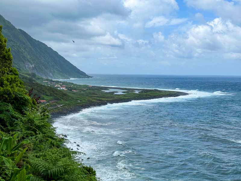
6 | São Jorge Island | Serra do Topo – Caldeira do Santo Cristo – Fajã dos Cubres | PR 01 SJO
By far one of the most popular hikes in the Azores on São Jorge Island is the PR 01 trail. This trail starts from the Eolic Park of Serra do Topo and highlights the unique fajãs of São Jorge Island.
Weather is a big factor on this hike as the elevation at Serra do Topo is just under 2,300 feet (700 meters) and descends to almost sea level. Serra do Topo is the starting point for two trailheads. Make sure to follow the trail north in the direction of Santo Cristo and not south to Fajã dos Vimes.
Do not attempt this hike if the weather is bad at the Serra do Topo. It’s crazy that it can be sunny along the shores of São Jorge Island and then have zero visibility from the highest point of the island.
If the weather is cooperating, take the trail down the steep hillside to the north side of the island past Cascata Pequena (small waterfall). The path leads to Fajã da Caldeira do Santo Cristo. Here find Caldeira do Santo Cristo, a protected coastal lagoon that is the only place where clams are cultivated on the Azores islands.
For me, Santo Cristo boasts the raw and rugged beauty of São Jorge’s rugged coastline. Many of the accommodation options here are adorned by experienced surfers. Although small, Santo Cristo has an Interpretation Centre, the Hermitage Chapel of Senor Santo Cristo, and two cozy restaurants.
Follow the dirt road out of Fajã da Caldeira do Santo Cristo to Fajã dos Cubres. The scenic path is delightful and flat with waterfalls, coastal views, and a chance to walk between two of the most beautiful fajãs in São Jorge.
There are ATVs allowed to use the dirt path, but their usage is limited to certain hours throughout the day. No cars can access the dirt path between the fajãs.
If the weather is not favorable at Serra do Topo, it’s easy with a car to hike between Fajã da Caldeira do Santo Cristo to Fajã dos Cubres as an out-and-back trail with no taxi required.
🥾 Serra do Topo – Fajã dos Cubres Trail Logistics
- Trail Number: PR 01 SJO
- Point to Point Trail: Serra do Topo to Fajã dos Cubres
- Distance: 5.9 Miles (9.5 Km)
- Duration: +/- 2.5 hours
- Difficulty: Moderate
- Official Serra do Topo – Fajā dos Cubres Hiking Trail
How to Reach The Trailhead in Serra do Topo
🚗 This is a point-to-point trail, so a taxi is essential for at least one leg of the hike. There is a small parking lot in Serra do Topo here. Arrange a taxi in Fajã dos Cubres or have one of the small bars help call one (if they are open).
🚗 If looking only to walk between Fajã dos Cubres to Fajã da Caldeira Santo Cristo park near here on the gravel road by the public restrooms.
7 | Graciosa Island | Subida ao Cume | PRC 05 GRA
For one of the more unique hikes in the Azores, head to Graciosa Island and complete the loop trail of Subida ao Cume.
The trail begins in the small hamlet of Luz and is blessed with forest trails, viewpoints along the ridge of Caldeira da Graciosa, and a chance to walk through volcanic caves.
The trail is quite challenging, and again, one of the biggest factors can be the weather. The highest viewpoint sits at an elevation of 1,329 ft (405 m).
Visit the Visitor Center for the Furna Do Enxofre Caldeira. This cave is accessible by 180 stairs and leads to a cold-water lake.
After that, continue on the trail to see two more volcanic caves, Furna da Maria Encantada and Furna do Abel. The trail returns to the village of Luz.
🥾 Subida ao Cume Trail Logistics
- Trail Number: PRC 05 GRA
- Loop Trail
- Distance: 6 Miles (9.7 Km)
- Duration: +/- 3.5 hours
- Difficulty: Hard
- Official Subida ao Cume Hiking Trail
How to Reach the Subida ao Cume Trail in Luz
The trailhead starts from the small village of Luz near the Church of Nossa Senhora da Luz.
🚗 Most visitors on Graciosa Island opt to sleep in Santa Cruz da Graciosa, which is close to the airport. The village of Luz is about a 15-minute drive from Santa Cruz da Graciosa.
🚌 Buses are limited but do run between Santa Cruz da Graciosa, Praia (ferry port), and Luz.
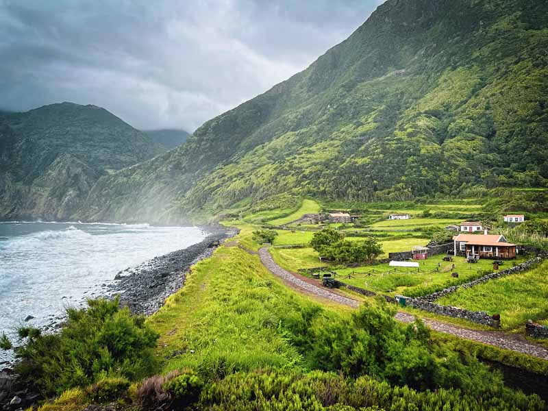
8 | Flores Island | Fajã de Lopo Vaz – Flores | PRC04 FLO

Submitted by Julie Fox of Julie Dawn Fox in Portugal
Flores Island is one of the least visited Azores Islands but is rich with waterfalls, crater lakes, caves, and lovely hiking trails.
Although relatively short, the linear trail to Fajã de Lopo Vaz is one of the best hikes in the Azores. The trail is steep so allow plenty of time, especially for the uphill climb back to the trailhead. The effort is well worth it, with views of the sheer green cliffs, waterfalls, and the black sand beach.
This fajã (the name given to a patch of fertile land that’s flat enough to cultivate crops) is named after one of Flores Island’s first settlers. Although these tiny fields have long been abandoned, the house on the beach has been renovated in recent years.
Take the opportunity to go for a dip at this secluded beach then follow the narrow stone path to the right of the house to pass the old huts, cottages and walled fields. You’ll arrive at a pebble beach that offers a closer look at the waterfalls cascading into the ocean from the cliff. Retrace your steps to complete the hike.
The trail itself is well-established, with steps and handrails where needed, although I recommend using a hiking pole, if possible, for leverage.
🥾 Fajã de Lopo Vez Trail Logistics
- Trail Number: PRC 04 FLO
- Out & Back Trail
- One-Way Distance: 2.1 Miles (3.4 Km)
- Duration: 2 hours
- Difficulty: Moderate
- Official Fajā de Lopo Vez Hiking Trail
How to Reach the Fajã de Lopo Vaz Trailhead
The walk starts at the picnic area and viewpoint called Miradouro da Fajã de Lopo Vaz, which is just outside the village of Lajes das Flores.
🚗The easiest way to reach the trailhead is by car with parking near the viewpoint.
🚌 Although there are no buses directly to this viewpoint, the Line 2 bus connects Lajes das Flores with Santa Cruz, while Line 3 goes from Fajã Grande. Remember bus times are limited on the smaller Azores Islands.
9 | Corvo Island | Caldeirão | PRC 02 COR
Corvo Island is the smallest Azores island, therefore, there are only two official PR trails! For those hikers looking for a unique hike in Corvo, take the circular loop trail around Caldeirão.
This hike starts near the Miradouro Caldeirão where there is a small parking lot and observation deck. Follow the trail through the collapsed crater. What’s unique about this crater is that the terrain inside the crater is similar to a wetland.
Find two lakes in the center, Lagoa do Cachimbo and Lagoa do Caldeirão. As the weather can be unpredictable around the crater, Caldeirão, it’s best to attempt this hike in favorable weather conditions.
🥾 Caldeirão Trail Logistics
- Trail Number: PRC 02 COR
- Loop Trail
- Distance: Just under 3 Miles (4.8 Km)
- Duration: 2.5 hours
- Difficulty: Moderate
- Official Caldeirão Hiking Trail
How to Get to the Caldeirão Trailhead
🚗 Corvo is small, but if you rent a car there is parking near the Miradouro Caldeirão.
🚕 Taxis are inexpensive and cost around 10€ from the main village of Vila do Corvo to the trailhead. Vila do Corvo has an airport and a ferry port plus a few accommodation options.
General Hiking Tips for the Azores Islands

To enjoy all the best hikes in the Azores, it’s good to be mindful of the weather, check in on current trail conditions, and carry a well-stocked day pack.
Here are all the best tips to have a successful hike on any of the Azores islands.
✔ Never Hike on Closed Hiking Trails
All of the official hiking trails in the Azores are well-maintained by each island. Every trail has a detailed map at the trailhead, numerous sign markers, and blazes painted on the trails.
Each Azores Island has superb tourist information centers that provide up-to-date information on every single registered hiking trail on the island.
Due to heavy rains, there can be trail closures. Oftentimes this is due to landslides and rockslides, or high waters. Additionally, some hiking trails close due to possible seismic activities. This is quite common and in 2022, São Jorge was voluntarily evacuated due to numerous tremors.
Always respect and honor trail closures. The Azores Trails Official Tourism Website provides the most current trail conditions and closures.
✔ Be Mindful of the Unpredictable Weather

Remember, the Azores islands are found smack-dab in the middle of the Atlantic Ocean. The weather is known to be volatile and is constantly changing. While the weather can change fast, it’s never a good idea to start a hike during heavy rains or with zero visibility from fog.
Many of the hiking trails are dirt paths. With heavy rains, many of the trails can in return be muddy and slippery. Depending on the hiking trail in the Azores, some can be lined with stones and rocks, which become slippery and dangerous in rain storms. Some pathways provide handrails, but many do not.
One amazing thing about traveling in the Azores is the SpotAzores webcams. These useful cameras are placed around all of the nine Azores islands. While it is helpful to check in on the weather cameras, the weather can change fast. However, the SpotAzores webcams can come in handy for planning hikes on the Azores.
✔ Stay on the Hiking Trails
Although gaining in popularity the Azores, the Azores islands remain an eco-destination. Many of the hikes in the Azores are found in protected landscapes, UNESCO biospheres, and natural parks. To help maintain these fragile ecosystems always stay on the hiking trails.
All of the official hiking trails are marked with red and yellow blazes and signboards. Practice the leave no trace philosophy by leaving behind only footprints and packing in and out all your garbage. Always stay on the official and designated hiking trails.
✔ Carry Enough Water & Proper Gear
Always carry a day pack when hiking in the Azores. Whether it’s a short day hike or a full day hike, always be properly prepared.
One thing is to never leave without enough water. Sometimes there are water fountains to refill bottles and sometimes not. I try to carry at least 1.5 Liters of water for day hikes.
➯ Hey… don’t forget your Travel Insurance! I love SafetyWing
Packing List for Hiking in the Azores

A well-stocked day pack is essential for all of the hikes in the Azores Islands. The weather changes in an instant, so be prepared with layers, a rain jacket, and durable hiking shoes.
🎒 When backpacking through Europe with my Osprey Kyte 36 L pack, I typically bring my Sea to Summit Ultra-Sil Travel Day Pack. I also love the Osprey Day Pack Plus for day hikes.
⁉️ I never leave for a day hike without a First-Aid Kit that has at least one emergency blanket in it and a fully charged power bank to use with my electronics.
🥾 Altra Trail runners worked great in the Azores for me, but if you need ankle support, Salomon makes great trail runners. If you need even more support on your ankles, Salomon makes a solid hiking boot. If hiking during the rainy season, you may wish for a hiking boot by La Sportiva hiking boot or any type of solid Gortex hiking boot or trail runner.
🚰 Water in a Reusable Water Bottle
👣 Trekking Poles can come in handy to help with muddy trails, steeper ascents and descents, and balance in general.
🧦 Carry a packable rain jacket that is lightweight. I also love my Smartwool All-Season Merino Base Layer Long-Sleevelong Shirt to help with sun protection and a baseball cap or a buff. An extra pair of socks is amazing to change into mid-hike if the ones on your feet get wet.
👙 Some of the hikes in the Azores pass by waterfalls, thermal pools, or the beach so pack along a swimsuit. A pair of hiking sandals or flip-flops are nice along with a packable towel or a Turkish towel.
⌚️ An Apple Watch is great for recording hiking trails and check-in with daily fitness goals
💶 Euros for buses, restaurants, taxis, and other expenses. All of the hikes in the Azores are free, except for the permit to climb Pico Mountain. Remember that some of the hikes pass by Visitors Centers which often have an entrance fee.
Conclusion | Best Hikes in the Azores by Island

In short, these are the best hikes in the Azores for each of the nine Azores islands.
These hiking trails in the Azores include diverse trails that boast waterfalls, tiny hamlets, crater lakes, unique fajã landscapes, and spectacular caldeiras. From central hilltops, volcanoes, and stunning shorelines, the Azores Islands are a hiker’s paradise.
This detailed hiking guide for the Azores includes trail information, trail logistics, and helpful tips to reach the trailheads. While most of these hikes in the Azores focus on day hikes, if you have a chance to complete a Grand Route on one of the Azores islands, do it!
Have you done any of these hikes in the Azores? Is there a hiking trail that you loved and I’m missing? Any current trail updates? Let me know in the comments below!
Pack This Post for Later! Pin It!


Disclaimer: There’s a chance this post contains affiliate links, and I receive a small (but grateful) portion of the sale. There’s no extra cost to you, and I only promote things that I use and love.