
7 Best Hikes in São Miguel Island Azores
The nine islands that make up the Azores archipelago are a hiker’s dream. These volcanic islands sit between the United States and Portugal in the middle of the Atlantic Ocean. The most visited island in the Azores is São Miguel island. The diverse hiking trails of São Miguel showcase trails that offer views of crater lakes, waterfalls, tea fields, and hilltop villages.
The best São Miguel hikes are found throughout the island and can be reached easily via car, on a tour, and by public transportation. In fact, was able to hike all of these incredible trails independently and utilized public transportation (except for one).
There are 30 officially registered São Miguel hiking trails on the island. However, there are numerous local trails (municipal) and beachside strolls. The Azores have done an excellent job maintaining and mapping out each trail. Hiking in the Azores, especially in São Miguel, is quite straightforward.
This hiking guide for São Miguel island includes my favorite day hikes on the island, how to reach each trailhead, tips for hiking on the island, and useful items for your day pack
Here are the 7 best hikes in São Miguel Azores.
Table of Contents
Disclosure: This is part of my Hikes & Adventures series, which means these treks can be strenuous and challenging. These are my experiences and I am not an expert. Please have all the proper equipment, verify the weather conditions, use professional resources, do your own research, be mindful of constantly changing trail conditions, and take into consideration your own physical abilities and/or limitations. These guides are for entertainment purposes only. Please see my full disclosure for more information here.
- Top Hiking Trails on São Miguel Azores
- São Miguel Hiking Tips
- São Miguel Hiking Day Pack List
- Where to Base for Hiking in São Miguel
- More Azores Island Hiking Trails
- Conclusion | Top Hikes in São Miguel Azores
7 Best Hikes in São Miguel Azores
These were some of my favorite hiking trails on São Miguel island. Each hiking trail is well marked with yellow and red blazes with informational signboards at each trailhead.
1 | Salto do Prego – Sanguinho – PRC 09 SMI
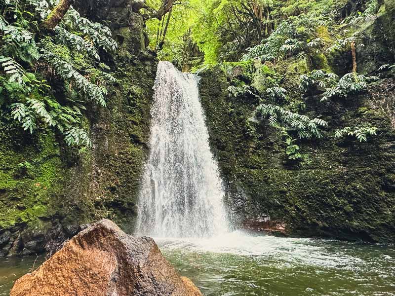
This was one of my favorite hikes on São Miguel and if you only have time for one hike, make it the Salto do Prego – Sanguinho trail.
Located on the east side of São Miguel, this trail begins in the village of Faial da Terra and leads to the stunning Salto do Prego waterfall. While the trail loops with the abandoned village of Sanguinho, there is a challenging trail that leads to another waterfall, Salto do Cagarrão.
Both waterfalls offer a chance to take a dip in a cool freshwater pool. The trail boasts many scenic viewpoints, trails that twist through the forest, and the small hamlet of Sanguinho, an almost forgotten village.
The trail is a loop from Faial da Terra and is relatively moderate. Adding the second Cagarrão makes the hiking trail more challenging.
🥾 Salto do Prego Sanguinho | PRC 09 SMI Loop Trail (with Salto do Cagarrão Detour on PR 11 SMI) | My Personal Distance: 5.4 Miles (8.7 Km) | Duration: Around 4 hours | Salto do Prego Sanguinho Hiking Map
How to Reach the Trailhead for Salto do Prego Sanguinho
Hikers will have to start this hiking trail from Faial da Terra on the east side of São Miguel island.
🚗 A car is essential for hiking Salto do Prego Sanguinho, especially for those staying in Ponta Delgada. Cars have ample space to park on the road on R. do Burguete. Parking is free and on a first come first serve basis.
🚌 Buses are nearly impossible to use to reach the Salto do Prego trailhead. While there are buses to Povoacao from Ponta Delgada, the walk to reach the trailhead in Faial da Terra requires at least 3 hours. With the distance and time for all the trails (almost 4 hours), buses are out of the question.
This is a popular hiking tour of Salto do Prego and Povoacao. Another top-rated Full Day Hiking Faial da Terra tour includes both Prego and Cagarrão Waterfalls.
2 | Rota da Água – Janela do Inferno – PRC37 SMI
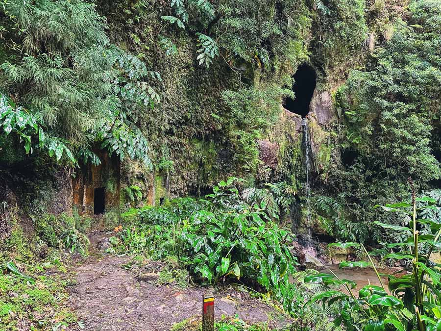
The Janela do Inferno is another one of the best hikes in São Miguel Azores. The trail gets its name from the unique small stream waterfall that spews from a cave. The name is Janela do Inferno, which translates to the “window to Hell.” Let me just say though, there is absolutely nothing hellish about this beautiful hiking trail.
The Janela do Inferno trail kind of has it all. The trail loops through an almost enchanted feeling forest. As it’s part of the old water route, find remnants of old water tunnels, and aqueducts. These water systems once carried fresh water from the streams to the Alcohol Factory of Lagoa.
Although the factory closed its doors in the late 20th century, these water channels and system still provides drinking water to the nearby municipalities.
The loop trail’s highlight is the water spout of Janela do Inferno. Although, between the tunnels, moss-covered aqueducts, and distant views of the Lagoa and Ponta Delgada, this is one of the more unforgettable hikes in São Miguel.
Don’t forget a headlamp or some sort of light source for the many stretches of tunnels!
🥾 Janela do Inferno | PRC37 SMI Loop Trail | My Personal Distance: 5.6 Miles ( 9 Km) | Duration: 2.5 hours | Janela do Inferno Hiking Map
How to Reach Rota da Água – Janela do Inferno Trailhead
The Janela do Inferno trailhead is found close to the village of Remédios da Lagoa. The parking lot for the trailhead offers a tourist information center, restrooms, a picnic area, and plenty of parking spaces.
🚗 Cars can find a free parking lot here. Next to the car park is a Tourist Information Center on one end and a picnic area with covered tables on the other. The picnic area also has free bathrooms.
🚌 There are some direct buses from Ponta Delgada to Remédios da Lagoa run by bus company Varela e Cª Lda. The direct buses only run a few times per day, so make sure to check the current bus schedule.
Alternatively, the easiest way to use the bus system is to take a bus in the direction of Vila Franca do Campo. You’ll need to exit the bus just after Lagoa and then walk on a car road for about 30 minutes to the trailhead.
🚌 Buses Ponta Delgada – Remédios da Lagoa | Varela e Cª Lda Bus Company | Buses depart from here in Ponta Delgada, sea side of the street | Average Fare: €2.80 | Duration: 35 minutes
This Half-Day Walking Tour Janela do Inferno and Lagoa do Fogo is a great option for those looking to complete this under-the-radar São Miguel hike.
3 | Miradouro da Grota do Inferno

Arguably one of the most iconic views of São Miguel is Miradouro da Grota do Inferno. The name translates from Portuguese to Hell’s Mouth Viewpoint. This mirador offers panoramic views of Lagoa Azul (Blue Lake), Lagoa Verde (Green Lake), Lagoa de Santiago (Santiago Lake), and Lagoa Rosa.
Gazing out into the distance it’s possible to see the Ocean and the form of the unique crater-shaped landscape. The crater lakes and village of Sete Cidades are spectacular on a clear day.
To reach Hell’s mouth takes little effort to appreciate the views. There is a parking lot near Lagoa do Canario. From the lot, it’s a short .8-mile hike on a dirt road. The road opens up to a pathway and observation deck.
Be mindful that oftentimes the viewpoint can be covered in fog and that it can be extremely windy. This is a popular day trip from Ponta Delgada, so expect crowds during the daytime.
🥾 Miradouro da Grota do Inferno | Out & Back Trail | Distance: 1.6 Miles Round Trip (2.6 Km) | Duration: 1 hour or longer depending on how long you stay at the viewpoint
How to Reach Miradouro da Grota do Inferno

🚗 Cars can find a free parking lot here. From here follow the dirt road to the observation deck.
🚌 Buses run from Ponta Delgada to Sete Cidades but don’t stop near the mirador. To reach the mirador, you’ll need to take a taxi from Sete Cidades or combine it with a crater lake hike.
Hikers may want to check out this Walking tour to Sete Cidades with a picnic lunch
4 | Mata do Canário – Sete Cidades – São Miguel PR4SMI

Hikers who want to experience the beauty of the Sete Ciadades should choose to do one of the crater hikes. For me, I opted for Mata do Canario, but I took this point-to-point trail in the opposite direction. However, it can be hiked in either direction.
You’ll need a taxi at either end of the trailhead to return to the village or the parking lot.
As I took the bus to Sete Cidades, I left the village and followed the trail for Mata do Canário. This route followed Lagoa Azul along the north and east shores. As a result of this direction, my trek was uphill and a little more challenging.
Highlights of this São Miguel hiking trail include the Miradouro das Cumeeiras, which is much less crowded than the Miradouro da Grota do Inferno. This is one of the best views of Lagoa Azul. The trail continues along the crater lake to Pico da Cruz, the tallest peak on the trail at 2,792 feet (851 m).
The trail continues to the old aqueduct. This leads to the main parking lot where you can arrange for a taxi pick up back to Sete Cidades. If you haven’t visited Miradouro da Grota do Inferno, it is a short hike to the viewpoint.
🥾 Mata do Canário – Sete Cidades |PR4SMI Point to Point Trail |Distance: 7.35 miles (11.8 Km) | Duration: +/- 3 hours | Mata do Canario Hiking Map
Be mindful that this trail is shared with quads and ATV tours, which can take away from the serenity of this hiking trail in São Miguel.
How to Reach Sete Cidades and Mata do Canário Hiking Trail

🚗 Cars can find a free parking lot here for the Mata do Canário – Sete Cidades hiking trail. Remember, you’ll arrive at the village of Sete Cidades where you’ll need a taxi back to the parking lot, or hike the trail back.
🚌 There are some direct buses from Ponta Delgada to Sete Cidades run by bus company Auto Viação Micaelense. Some buses may require a transfer at either of the villages of Várzea or Ramal dos Mosteiros. Always check the current bus schedule.
🚌 Buses Ponta Delgada – Sete Cidades | Auto Viação Micaelense | Buses depart from here in Ponta Delgada, near the Tourist Information Center | Average Fare: €4 | Duration: at least 1 hour, but longer if a transfer
Without a car, sometimes a tour is the best option, like this half day 4WD Tour of again a hiking tour of Sete Cidades. A majority of the hiking trails of Sete Cidades showcase the alternative Vista do Rei trail that follows the southwest slope of Sete Cidades Lagoa Azul.
5 | Chá Gorreana – PRC28 SMI
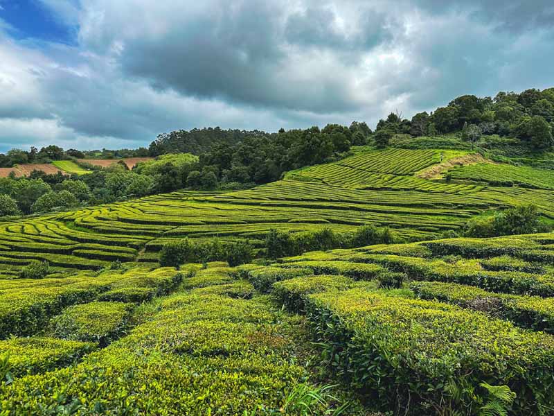
One of the best hikes in São Miguel is found at the ground of the island’s oldest-running tea plantation, Chá Gorreana.
The beginning section of the trail follows along the hedges of the Camellia Sinensis shrubs. The dirt trails loops along the fields and provide stellar views of the tea fields. While you don’t have to do the entire loop hike, I think the entire trail offers a mixture of tea fields, forest paths, and ocean views.
The trail will ascend towards a tree-shaded forest and boasts views of the Gorreana Tea Factory and the ocean on a clear day.
The loop will eventually descend and return to the opposite side of the tea fields. The descent is fairly steep, but there is a wooden handrail that can assist hikers on the way down.
🥾 Chá Gorreana Tea Trail | PRC 28 SMI – Loop Trail | Distance: 3.4 Km (2.1 Miles) | Duration: +/- 1 hour | Chá Gorreana Hiking Map
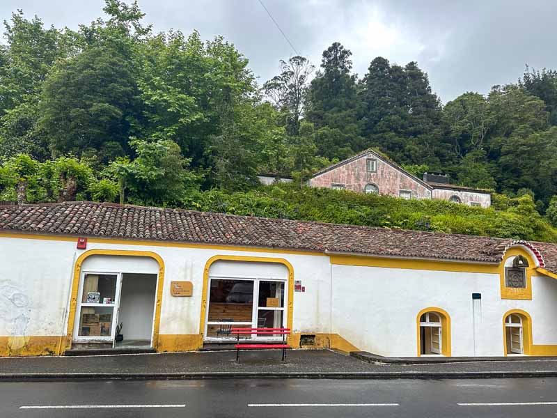
After hiking the loop trail through the tea plantation, enjoy a free tour of the Gorreana Tea Factory, sip on tea samples, or walk the short, but worthwhile Municipal trail at Gorreana.
How to Get to Gorreana Tea Factory

The hiking trail for the Tea Plantation on São Miguel is found across the street from the Gorreana Tea Factory.
🚗 Cars can park in the large parking lot of the Gorreana Tea Factory
🚌 From Ponta Delgada hop on a frequent bus to Ribeira Grande. In Ribeira Grande, wait for a bus in the direction of Maia. Exit the bus at this bus stop. It’s about a 15-minute walk from the bus station to Gorreana Tea Plantation. Make sure to follow the road to the backside of the factory to avoid walking on the busy EN1-1A road.
The Gorreana Tea Plantation is a popular stop for tours, so join a Half-day Gorreana – Pedestrian Walk and Tea Tasting
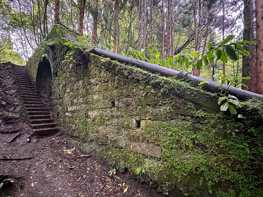
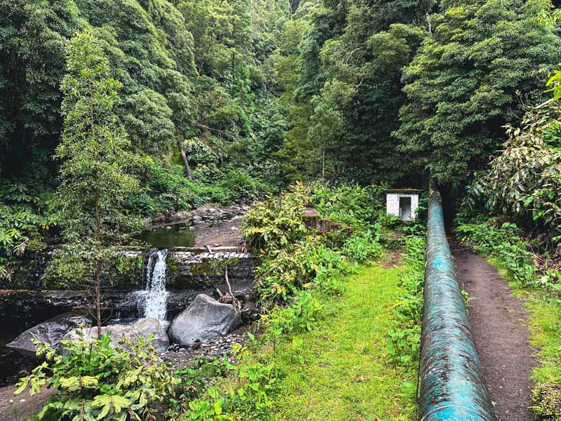
6 | Trilho Caminho da Água da Gorreana – TM 05

Another hidden gem hike at Gorreana Tea Plantation is the municipal trail of Caminho da Água da Gorreana. This short little trail is found right in the parking lot of Gorreana Tea Plantation and is often skipped.
This hiking trail showcases the importance of water for the Gorreana Tea Factory. The trail twists alongside the Gorreana Stream and shows how the water from the Cidreira Waterfall helped with the success of the Gorreana Tea Factory.
Highlights of this municipal trail include the water holding tank, an old Roman arch bridge, the ruins of an old stone water mill, and the waterfall of Cidreira (Salto do Cidreira).
🥾 Trilho Caminho da Água da Gorreana | TR 05 Ribeira Grande Municipal Trail | Distance: 1.7 Km round-trip (A little over 1 Mile) | Duration: +/- 40 minutes | Here’s my Wikiloc Trail for Trilho Caminho da Água da Gorreana
How to Reach This Underrated Hiking Trail in São Miguel
Again, this trailhead begins right from the parking lot of the Fábrica de Chá Gorreana. As this is a municipal trail, there are no organized tours for this hiking trail yet.
Either arrive by car or bus to enjoy this underrated hike in São Miguel.
7 | Caldeiras da Ribeira Grande – Salto do Cabrito – PRC 29 SMI
The Salto do Cabrito trail is a great loop that showcases the many natural highlights of São Miguel island.
The Salto do Cabrito hike is located between Lagoa do Fogo, a stunning crater lake, and the village of Ribeira Grande. The casual hike can be easily visited independently and includes a waterfall, a dam, and a chance to soak in some rustic hot springs on São Miguel.
The parking lot is just a short walk to the Cabrito Waterfall. While it’s not one of the more spectacular waterfalls of São Miguel, I think the loop trail is what makes this hike worthwhile.
After the waterfall, follow the trail through the lush vegetation of Japanese Cedars and ferns. The trail sections that follow along the hydroelectrical pipeline add a dash of adventure. The small trail to gaze at the Fajã do Redondo Dam makes for a great detour.
After the dam, head to Caldeiras village where it’s possible to soak in the Termas das Caldeiras by the hour. Alternatively, if you worked up an appetite, stop at Restaurante – Bar Caldeiras to sample the local Cozido stew. This dish was slow-cooked in the underground caldeiras.
The trail continues back to the parking lot near the Cabrito Waterfall.
🥾 Salto do Cabrito | PRC 29 SMI Loop Trail | Total Distance: 5.25 Miles (8.5 Km) | Duration: +/- 2.5 hours walking time | Salto do Cabrito Hiking Map
How to Reach the Salto do Cabrito Trailhead
🚗 Cars have two options for parking. This is a free parking lot here near the Cabrito Waterfall. Another great place to park is at the official trailhead parking near Caldeiras.
🚌 From Ponta Delgada hop on a frequent bus to Ribeira Grande. From here hail a taxi to Caldeiras or walk 2 miles along a road to merge with the hiking trail.
🚌 Buses Ponta Delgada – Ribeira Grande | CPR Bus Company | Buses depart from here in Ponta Delgada, sea side of the street | Average Fare: €2.80 | Duration: 45 minutes
This Half-Day Walking Tour of Salto do Cabrito is a great option for those looking to hike Salto do Cabrito. If looking for a different way to experience the waterfall, try Canyoning in Salto do Cabrito
Tips for Hiking São Miguel Azores
The island of São Miguel has 29 registered hiking trails. Again, these are just the official island trails and do not include the numerous municipal and local hiking trails on São Miguel island.
To enjoy all the best hikes in São Miguel, follow these simple tips.
✔ Be Mindful of the Weather

As the Azores islands are found in the middle of the wild Atlantic Ocean, the weather can change in an instant. All of the Azores are very green and lush and this is due to the frequent rainfalls. Never hike in extreme weather or heavy rains.
Many of the hiking trails are dirt paths, so the trails can often be muddy and slippery. Again, there are sections with stones and rocks, which can become slippery and dangerous. Many of the waterway paths have metal walkways, which can always be hazardous during heavy rains. pathways can also be a slip hazard, but they are aided with handrails.
One amazing thing about traveling around the Azores is the SpotAzores webcams placed around the islands. While it is helpful to check in on the weather cameras, the weather can change at a moment’s notice.
✔ Do Not Hike on Closed Hiking Trails
All of the trails are well-maintained by the island. That means the tourist information center provides up-to-date information on every single registered hiking trail on the island. Due to heavy rains, there can be chances of trail closures due to landslides and rockslides.
Always respect and honor trail closures.
✔ Stay on the Hiking Trails
Although gaining in popularity the Azores, the Azores islands remain an eco-destination. Many of the hikes in São Miguel are found in protected landscapes and UNESCO biospheres. To help maintain these fragile ecosystems always stay on the hiking trails.
All of the official hiking trails are marked with red and yellow blazes and signboards. Practice leave no trace philosophy by leaving only footprints and staying on the hiking trails.
✔ Carry Enough Water & Proper Gear
Always carry a day pack when hiking in the Azores. Whether it’s a short day hike or a full day hike, always be properly prepared.
One thing is to never leave without enough water. Sometimes there are water fountains to refill bottles and sometimes not. I try to carry at least 1.5 Liters of water for day hikes.
Never underestimate the fast-changing weather on any of the Azores Islands. In one hour it’s possible to cycle from sunny skies to rain to strong winds.
A well-stocked day pack is essential while hiking in the Azores. The weather can change fast so a light rainjacket and dry layers are nice to have in reserve. I always carried an extra pair of socks and hiking sandals, too.
➯ Hey… don’t forget your Travel Insurance! I love SafetyWing
What to Pack for Hiking São Miguel Azores

My day pack always accompanied me on every single day hike in the Azores. The weather changes fast, so always be prepared.
🎒 When backpacking through Europe with my Osprey Kyte 36 L pack, I typically bring my Sea to Summit Ultra-Sil Travel Day Pack. I also love the Osprey Day Pack Plus for day hikes.
⁉️ I never leave for a day hike without a First-Aid Kit that has at least one emergency blanket in it and a fully charged power bank to use with my electronics.
🥾 Altra Trail runners worked great in the Azores for me, but if you need ankle support, Salomon makes great trail runners. If you need even more support on your ankles, Salomon makes a solid hiking boot. If hiking during the rainy season, you may wish for a hiking boot by La Sportiva or any Gortex hiking boot or trail runner.
🚰 Water in a Reusable Water Bottle
👣 Trekking Poles can come in handy to help with muddy paths and steeper ascents.
🧦 Carry a packable rain jacket that is lightweight. I also love my Smartwool All-Season Merino Base Layer Long-Sleevelong Shirt to help with sun protection and a baseball cap or a buff. An extra pair of socks is amazing to change into mid-hike if the ones on your feet get wet.
👙 Some of the hikes in São Miguel pass by waterfalls or thermal pools, so throw in a swimsuit. A pair of hiking sandals or flip-flops are nice along with a packable towel or a Turkish towel.
⌚️ An Apple Watch is great for recording hiking trails and check-in with daily fitness goals
💶 Euros for buses, restaurants, hot springs, taxis. All of these hikes in São Miguel are free
Where to Stay in São Miguel Azores

Most people visiting São Miguel will opt to sleep in Ponta Delgada and either rent a car or utilize the buses or tour companies.
There are many accommodation options in Ponta Delgada from hostels, guesthouses, apartments, and hotels.
Top Rated Places to Stay in Ponta Delgada Azores
➜ Vintage Place – Azorean Guest House
➜ Casa da Galeria – Azores Art of Hosting
Additionally, some visitors like to stay in smaller villages like Furnas or Vila Franca do Campo.
➜ Browse All the Places to Stay on São Miguel Island
More Azores Island Hiking Trails

The Azores Islands are becoming known as a top hiking destination in Europe. Each island of the Azores offers fabulous hiking trails.
After São Miguel, most travelers will visit the triangle islands of the Azores. The triangle islands of the Azores include the islands of Pico, São Jorge, and Faial.
Pico is known for being home to the tallest mountain in Portugal, Pico. Most visitors will take the challenging hike up the volcano. Additionally, Pico Island is known for its spectacular wines. Another fabulous hike on Picos is the Vinhas da Criação Velha Vineyard walk along the seaside.
Faial is famous for the Capelinhos Volcano and the Interpretation Center. Faial Island is also known for its incredibly lush Caldeira that can be hiked down only via a guided tour for conservatory issues. Alternatively, it’s possible to hike along the crater and merge on the Ten Volcanoes hike.
Sāo Jorge island is famous for its unique and beautiful fajãs. There are plenty of hikes on São Jorge but perhaps the most stunning stretch of coastline is between Fajã dos Cubres to Caldeira Santo Cristo. On São Jorge, make sure to visit a cheese factory and swim in the spectacular natural pools.
If looking for a mind-blowing multiday trek on the Azores, I can’t recommend the Great Route of Santa Maria. Located to the south of São Miguel, Santa Maria is one of the more underlooked Azores Islands. The Grand Route circles the entire island and is by far my favorite trek in the Azores.
Conclusion | Best Hikes in São Miguel Azores

This is the ultimate hiking guide for São Miguel Azores. These are my favorite hikes in São Miguel that I completed on my week-long stay on the island.
There are so many hiking trails in São Miguel, but I think this list includes a diverse range of trails that highlight waterfalls, villages, crater lakes, and water routes.
This hiking guide includes overviews of each trail and how to reach the trailhead. As I spent over three weeks hiking in the Azores, I’ve included some of my best hiking tips and useful gear.
These seven hikes in São Miguel are perfect for first-time visitors of this beautiful Azores Island.
Have you completed these hikes in São Miguel? What other hikes in São Miguel would you add to this list? Let me know in the comments below!
Pack This Post for Later! Pin It!

Disclaimer: There’s a chance this post contains affiliate links, and I receive a small (but grateful) portion of the sale. There’s no extra cost to you, and I only promote things that I use and love.


