
How to Walk the Incredible Camino Dragonte Route | Camino Frances Detour
Traverse beautiful mountainsides, walk through untouched villages, all while appreciating the stunning Valcarce Valley views. Find yourself wandering through forests filled with chestnut trees in solitude. This is the incredible Camino Dragonte hiking route.
The Camino Dragonte is a challenging trek through the mountains. This is an intrepid and difficult detour option on the Camino Frances pilgrimage route in Spain.
The Camino Dragonte detour starts from Villafranca del Bierzo, an extremely popular pilgrim village found along the Camino de Santiago French Way. The Dragonte route climbs up to the open and exposed mountains and rejoins the original Camino route in the riverside valley village of Las Herrerias.
The Camino Dragonte, or Ruta Dragonte, sees very little foot traffic. In fact, far less than 1% of pilgrims walking to Santiago de Compostela on the French Way attempt this hiking route.
This hiking guide includes a downloadable Camino Dragonte map, useful tips, and what to expect along the remote Camino Dragonte route.
Here’s the complete hiking guide on the Camino Dragonte route on the Camino Frances.
Table of Contents
Disclosure: This is part of my Hikes & Adventures series, which means these treks can be strenuous and challenging. These are my experiences and I am not an expert. Please have all the proper equipment, verify the weather conditions, use professional resources, do your own research, be mindful of constantly changing trail conditions, and take into consideration your own physical abilities and/or limitations. These guides are for entertainment purposes only. Please see my full disclosure for more information here.
- Map & Overview of the Camino Dragonte Route
- Preparing & Useful Tips for the Camino Dragonte
- Hiking Guide for the Camino Dragonte Route
- Sleep in Las Herrerias after the Camino Dragonte
- [Bonus] Another Route Similar to the Dragonte Route
- Don’t Miss the Incredible Camino Dragonte Detour Route
Map and Overview of Camino Dragonte | Ruta Dragonte
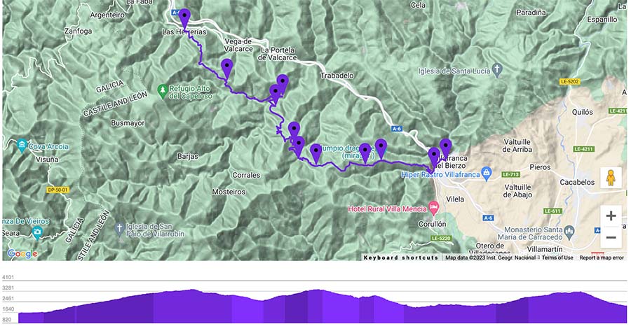

Camino Dragonte Overview
Be mindful that the Camino Dragonte is very different than the typical Camino de Santiago daily routes. It’s more mountainous and more isolated. Be honest with yourself about your physical limitations.
This Camino Frances detour is best for those seeking solitude and who are experienced with hiking in the mountains.

- Point to Point Trail
- The Camino Dragonte is a challenging Camino Frances detour from Villafranca del Bierzo to Las Herrerias Spain
- Official Trail Name: Camino Dragonte or Ruta Dragonte / GR -11
- Trail Markers are far and few between, and an offline map is almost essential
- Look for white signboards with black arrows that label the next point of interest with Kilometer distances
- I never saw any GR trail markers
- Difficulty: Challenging, due to the limited way markers, remoteness, and traversing the open and exposed mountainsides
- Distance: 17.81 miles ( 28.7 km)
- Excursion Duration: The Ruta Dragonte takes around 7 – 10 hours, depending on breaks, physical abilities, weather, etc.
- Most hikers following the Camino Dragonte Way are pilgrims walking the Camino de Santiago – Camino Frances Route
- Camino Dragonte Packing Essential
- First-Aid Kit
- Emergency Blanket
- Reusable Water Bottle (Filled)
- Trekking Poles
- Hiking Boots or trail runners, whatever shoes you decide on for your Camino
- Pilgrim Credencial (Pilgrim Passport)
- Long Quick-Dry Hiking Pants are useful, as many areas of the trail are overgrown with scratchy grasses. I wore shorts and regretted it.
- Smartwool Merino Long Sleeve Base Layer is excellent to help protect from the sun and overgrowth
- Buff, floppy hat, or baseball cap for sun protection
- Sunscreen
- BUG SPRAY & BUFF, as the insects can be unbearable at certain times of the year
- Power Bank to make sure you don’t get stranded in the mountains with a dead phone and no offline map
- Be mindful that the weather in the mountains can change rapidly, so always be prepared for bad weather
- An offline Camino Dragonte Map & John Brierley’s Guidebook for the Camino Frances has a nice overview
- I recommend downloading Maps.Me, one of my favorite Camino Apps
Preparing for the Camino Dragonte
Here are a few useful tips when planning on walking the Ruta Dragonte.
Sleep in Villafranca del Bierzo the Night Before

It’s best to sleep in Villafranca del Bierzo Spain, the night before walking the Ruta Dragonte. The Camino Dragonte is a full-day trek, and there is really no place to sleep until Las Herrerias.
Since this is a full-day trek, try to depart Villafranca del Bierzo early. Plan on the Camino Dragonte to take at least 8 hours.
There is a Municipal Albergue in Villafranca del Bierzo that works on a first-come, first-served basis.
- Pilgrim Beds: 60 / €10
- Open: March 1 – December 15 with the Doors opening at 13:00
- Pilgrim Credential Required: Yes
- Contact Points | Email: info@villafrancadelbierzo.org
- Reservations can be made for the same day
➜ Browse all the Places to Stay in Villafranca del Bierzo
Villafranca del Bierzo has a charming hilltop village feel, making it one of the most popular and memorable towns on the Camino Frances. This stage is one of the final stages before reaching the Galicia stage of the Camino de Santiago.
Since the village is a pilgrimage hub, it’s possible to find accommodation in private albergues, hostels, hotels, pensions, and more.
Things to See in Villafranca del Bierzo

Villafranca del Bierzo has a few worthwhile points of interest. Here are some things to casually see the night before the Camino Dragonte detour.
✔ The Plaza Mayor lined with cafes, restaurants, and lots of outdoor terraces
✔ Iglesia Colegiata (Church) is a beautiful church that can be visited by donation
✔ Alameda Garden are tranquil public garden that are worth a stroll
Tips Before Departing on Ruta Dragonte

If feeling weary about attempting the Ruta Dragonte, check in at the official tourism office in Villafranca del Bierzo. They should have more up-to-date information. If hiking during the shoulder season, they may be able to tell you about current trail conditions.
The office is located here near the lovely town gardens.
☛ Camino de Santiago Top Tip | One of the most up-to-date resources on the Ruta Dragonte is the useful and supportive Friends of Dragonte Facebook Group. Check this group before heading on this alternative Camino Frances detour
The Camino Dragone detour route is recommended for pilgrims who feel comfortable hiking in the mountains, are confident hiking without many way markers and signage, and have the ability to follow an offline map with ease.
It is best to walk the lonely route with at least another pilgrim or a small group. There will be little assistance in the mountains, and the cell service is spotty.
Please keep in mind your physical abilities and limitations before departing on the Camino Dragonte route. Carry enough food and water for the entire day. Do not rely on any of the villages to have any shops or cafes. Be prepared to be without cell phone service.
The highest pass is just under 3,500 ft, but the route has three major ascents and descents. The up and down can be hard on the knees and make for tired legs.
➯ Hey… don’t forget your Travel Insurance! I love SafetyWing
When to Walk the Camino Dragonte Route

The Ruta Dragonte is best hiked during the summer months. I completed this route at the beginning of September. It may be possible during the shoulder season, but remember, in the mountains, the weather can be unpredictable and can change in an instant.
As this alternative Camino route has many spots that are exposed, do not attempt this trail if the weather is bad. These mountains are known to get snow, so do not walk this route if there is heavy snow. Also, do not walk the trails if there have been recent heavy rains that could wash out trail sections.
Some of the trail sections are overgrown by brush. This can make some sections of the trail hard to follow. I wore shorts and had many scratches on my legs. Wear clothing that will protect yourself from the overgrowth.
☛ Remember the emergency number in Spain is 112, but cell service is not reliable on the Ruta Dragonte
Camino Dragonte Route Hiking Guide
Here’s a step-by-step breakdown of how to hike the Camino Dragonte route.
Villafranca del Bierzo to Dragonte


Depart early from Villafranca del Bierzo via the Medieval Bridge. This bridge crosses over the Burbia River. Follow the car road past the Hostal El Cruce. The road splits, but there is an official signboard here that marks the official start of the Camino Dragonte route.
Follow the paved road to the right uphill. The car road passes by lovely vineyards. We walked in September, so we actually got to witness the harvesting process, which was pretty cool. There are incredible vistas of Villafranca behind you, so make sure to take a glance over your shoulder.
Stay on the car road until it reaches the Dragonte village signboard. Not far after, there will be another Camino Dragonte signboard where the road splits. Head to the right.
The signboard officially calls this direction Dragonte Barrio de Arriba, which means upper Dragonte. It also shows Santiago de Compostela in the direction to the right.
The road leads you past a water fountain decorated with flowers and the official Area de Descanso.
Camino Dragonte Rest Area


All pilgrims should stop in at the Area de Descanso. This is a small mountain hut. Here, it’s possible to sign your name in the official binder and collect a pilgrim stamp. The string on the door is used to help release the locking mechanism.
This small hut could act as an emergency shelter if the weather abruptly changes. There is a small fireplace and basic kitchen supplies.
Be mindful of a semi-protective neighborhood dog that can be near the hut to “greet” you. He barked at us but allowed us passage.
When we hiked, the shelter had hand-drawn maps, but not sure if they are still maintained. There were also notes and updated information.
Make sure to double-check your supplies and fill your water bottle. Head out of town in the direction of Moral de Valcarce.
🥾 Villafranca del Bierzo to Dragonte Hut | Distance: 3.75 miles | Duration: 1.5 hours
Dragonte to Moral de Valcarce

The trail to Moral de Valcarce is pretty straightforward. The dirt path eventually meets a gravel road that leads to the tiny pueblo of Moral de Valcarce. There is a signboard here that directs you out of town.
There is a fork here at the end of the road in the village of Moral de Valcarce. There is a trail to the left and an uphill trail to the right. Take the left trail, which has an old water fountain that is no longer working. At the time we walked, there was a dog kennel across from the fountain. This is the correct trail that leads to Villar de Corales.


This area is not marked, so make sure to follow an offline Camino Dragonte map or ask the locals. We had to go back and ask twice for the correct directions!
Be mindful that English is not spoken in any of these villages so some sort of basic Spanish is necessary.
Moral de Valcarce to Villar de Corales


The trail continues on the dirt path. The next point of interest is an old abandoned stone mill. Here, you will need to turn to the right in front of the stone mill. There is a green arrow and writing on the stone mill that reads ➜ Santiago.
To continue on the Camino Dragonte, you must ford the small stream here. As we walked in September, the stream covered the trail for less than 200 feet or so. Be mindful that if walking during the springtime, this stream may be more profound and deeper.
The trail continues through an incredible chestnut forest. This was one of the most spectacular sections of the Camino Dragonte. There is a refreshing water fountain before the trail leaves the forest. Make sure to fill up your water bottle with cold water.
After the spring, the trail opens up and leaves the forest. There is a signboard that points in the direction of Villar de Corales
🥾 Villafranca to Villar de Corales | Distance: 8 Miles | Duration: +/- 6 hours
Villar de Corales to San Fiz de Seo

Villar de Corales seems almost abandoned. Although there are a few homes, we only saw sheep move in and out of the open doorways. Be mindful that there were a few dogs in this area that seemed to be watching the property.
Continue through the village and notice that the trail is fairly steep. After the village, the next section is open, and there is no forest protection. This part of the Camino Dragonte offers some of the most epic views of the hike.
Be mindful that this section of the trail was quite overgrown with itchy brush.
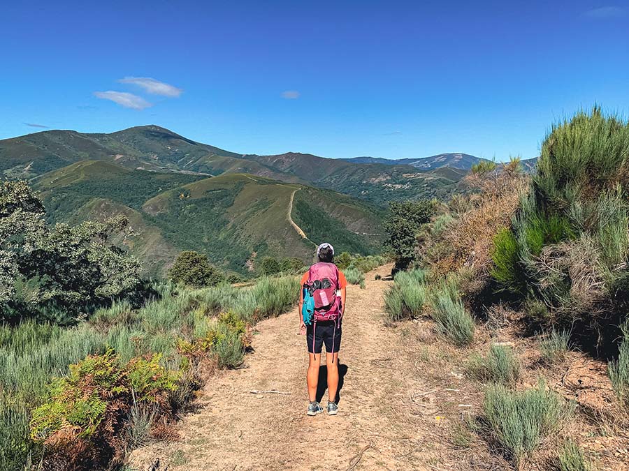
The Ruta Dragonte continues to traverse the mountainside. Soon, catch glimpses of the first views of San Fiz de Seo. The small village will be on the left with an active Quarry to the right. The dirt road follows right alongside the quarry, so be watchful of large machinery.
The descent into the village is a challenge since the road is loose gravel. Be careful and mind your footing.
San Fiz de Seo Village

San Fiz de Seo is another tiny village next to the Barjas River. We had planned on enjoying our lunch next to the river, but in all honesty, the bugs were attacking us. Instead, we opted to head towards the main plaza, where there was shade under a bench and a water fountain.
Be mindful that many of the water fountains don’t have signage for potable water. I drank from all the fountains, but drinking from the fountains is an individual choice.
We were lucky that the bugs were terrible near the Barjas River. Remember, the insects can be terrible at various sections of the Dragonte Camino path.
The plaza in San Fiz de Seo is marked with a small church.
🥾 Villafranca to San Fiz de Seo | Distance: 12.2 Miles | Duration: +/- 4 hours
Rejoin Camino Frances Route

Alternatively, if you wish to end the Camino Dragonte route at San Fiz de Seo, it is possible to rejoin the original Camino Frances route.
Return to the Valcarce Valley via the paved car road (LE-5110). The road leads to the original Camino Frances route just after Trabadelo and right before La Portela de Valcarce. I have not taken this route, but it is a possibility for those who don’t wish to continue through the mountains, are injured, or the weather has turned for the worse.
John Brierley’s Guidebook for the Camino Frances shows this option in his guidebook.
Camino Dragonte Route | San Fiz de Seo to Vilasinde


After a lunch break, head out of Vilasinde with an uphill climb. This area is also exposed and passes through a large bee-keeping area.
The Camino Dragonte route passes through another lovely chestnut tree forest. Look for one of the largest trees marked with a signboard “Castaño del Tio Guillermo.”
The trail leads to Vilasinde, a small village known for a small bar, Bar Celia.
Make sure to stop by and feel the warm welcome of Celia, who runs “one of the best bars on the Camino.” Celia is a sincere hostess and loves to share stories of pilgrims who have trekked the intrepid Camino Dragonte. She welcomes pilgrims with warm hospitality and a smile, although, the hours are extremely limited.
🥾 Villafranca to Vilasinde | Distance: 14.75 Miles | Duration: +/- 7 hours
Vilasinde to Las Herrerias

After Vilasinde, follow the trail out of town with another big ascent. The good news is this is the last and final ascent.
The bad news is that the downhill to Las Herrerias is grueling and steep. Trekking poles are highly recommended. Your legs will be more tired from all of the ups and downs of the Camino Dragonte by this point.
The trail reaches its end through another lovely forest. Follow the forest trail all the way to Las Herrerias.
Las Herrerias marks the ending point to the most intrepid, yet rewarding Camino Frances detour, the Ruta Dragonte.
🥾 Villafranca del Biezo to Las Herrerias | Distance: 17.81 Miles | Duration: +/- 8 hours
Sleep in Las Herrerias after the Camino Dragonte

After an almost 18-mile day trek through the mountains, Las Herrerias is a welcome retreat. The small village sits picturesquely along the Rio das Lamas and has a handful of places to stay in Las Herrerias.
After a long and grueling trek, you may wish to book accommodation in advance. It’s another 2.25 miles to reach the next village of La Faba. Spoiler alert: La Faba is mostly an uphill climb from Las Herrerias.
Las Herrerias has plenty of authentic restaurants to choose from. Soak your tired feet in the nearby river. Enjoy the solitude and peaceful ambiance of Las Herrerias de Valcarce.
The following day, pilgrims will be welcomed into the incredible autonomous community of Galicia.
Places to Stay in Las Herrerias de Valcarce
Albergue Refugio Las Herrerias (Miriam) takes advantage of the charm with an inviting garden lined with hammocks. The modern albergue is cozy with an open dining room and community room filled with games and more. Additionally, there are washers and dryers on-site.
Albergue Miriam Las Herrerias includes a hearty pilgrim breakfast with the price.
Psst… Miriam Albergue in Las Herrerias was one of my favorite Camino Frances Abergues.
More Las Herrerias Accommodation Options
➜ Casa Lixa Hotel Rural Albergue
➜ Paraiso del Bierzo (Hotel Outside of Town)
➜ La Torre (Casa Rural)
➜ La Pandela (Private Rooms)
➜ Casa Polin (Hotel with Restaurant)
➜ Casa Do Ferreiro – La Fragua (Private Rooms)
More Camino de Santiago Guides


[Bonus] Another Route Similiar to the Camino Dragonte
I walked the Camino Dragonte on my first Camino de Santiago route. I still stand by that it was one of my favorite days on the Camino Frances.
For those pilgrims who want a chance to experience what the Camino must have been like centuries ago, the Camino Dragonte is a must.
However, those who want to experience a similar route may end up skipping the Camino Dragonte completely and diverting off the Camino Frances.


In Ponferrada (before Villafranca), there is a chance to divert off the Camino Frances and onto the Camino de Invierno. I highly recommend this for pilgrims looking to get off the beaten path.
Again, if you are an experienced hiker and want to take a spectacular route, walk through the Ozo Valley and the Aquilianos Mountains as a detour. This takes pilgrims to Peñalba de Santiago on a spectacular route that is similar to the Dragonte, but spans over 2 – 3 days. Again, these days were my absolute favorite on the Camino de Invierno.
This is another isolated route that requires good weather, the ability to read an offline map, and experience in the high mountains.
Along the way, pass through small villages, stunning river valleys, tiny pueblos, and ancient churches in the Valle del Silencio. Eventually, the route follows the Old Roman Canals through these untouched mountains and leads to the stunning Las Medulas.
Remember, if you opt for this route, you’ll be on the Camino de Invierno, which is less crowded than the final stages of the Camino Frances.
Don’t Miss the Incredible Camino Dragonte Route

In short, the Camino Dragonte is one of the most epic detours on the Camino de Santiago – Camino Frances pilgrimage route. The Camino Dragonte was one of my favorite days on my entire walk to Santiago.
This intrepid trail is unique as it traverses mountains, passes through tiny pueblos, and twists through magical chestnut forests.
While the Camino Dragonte route is alluring, it is best suited for more experienced hikers. This challenging trail is only completed by less than 1% of pilgrims.
This Camino Dragonte hiking guide includes a map, useful tips, and what to expect on the trail.
Have you hiked the Camino Dragonte route? What did you think of it? Is there anything in this hiking guide that needs to be updated? Please let me know in the comments below!
Pack This Post for Later! Pin It!

Disclaimer: There’s a chance this post contains affiliate links, and I receive a small (but grateful) portion of the sale. There’s no extra cost to you, and I only promote things that I use and love.


Hi, Megs. Thank you for your wonderful Dragonte posting. I am the administrator of “Friends of Dragonte,” and I provide the stamp and sign in book at the Descanso. You may also have seen some of my yellow arrows along the route. I first more or less stumbled upon the route in 2015 at age 68, and then went back the next year to paint some arrows. Returned in ’17, ’18, ’19 and ’22. That is my bottle of cleaning liquid on the table during your visit. I was there in August and the place was a mess! I hope it is okay with you that I shared your post on some Camino facebook sites as well as my own page. It gives me joy to see you making this walk more well known to adventure lovers from around the world. Your pictures and your commentary are amazing. The only “quibble” I have is when you mention the ability of returning, if wanted, to the “original” Camino. The Dragonte was a part of the original Way. The church/monastery ruins you come upon just before Villar de Corrales are remnants of a pilgrim’s hospital in the Middle Ages. Mostly likely the route was intended to provide an alternative to the valley route because of “toll collectors” and/or bandits encountered leaving Villafranca del Bierzo and afterwards. Please feel free to join “Friends of Dragonte.” Recently I drew a crude map of why I think there is that walk in the stream past Moral de Valcarce. There is a recent charming story about a dog that seems to be accompanying pilgrims from Moral to Herrerias. Again, many thanks, and how I envy your lifestyle! Patrick Eibergen
Patrick thank you so much for reaching out! I used the Friends of Dragonte Facebook group to give me peace of mind before embarking on this hike.
Thank you for all the work that you do for the trail and the wealth of information you have supplied. I had no idea the history or that Dragonte was part of the original Camino.
I have seen the posts about the guardian angel dog that has been walking with hikers. It really is a special route.
Again, thank you for all the work you have done for the Camino Dragonte.💙
Megs
Hi Megs,
Thanks for all the amazing information that you have gathered and posted here. I used your information to hike the Dragonte on October 2nd of this year (2023). To the info you have posted, I would only add the following bits of emphasis. (1) The Area de Descanso has a string sticking out of the door to disengage the release mechanism. I thought it might be a bell and didn’t want to pull on it at 6:30am. A fellow Dragonte hiker enlightened me later. (2) Bring all your water and food. There may be places to refill your water, but don’t count on it. The one fountain I did find in San Fiz do Seo did not have signage to say if it was potable or not, so I erred on the side of caution. (3) Add a buff to your Essentials list. The files were relentless for hours on my hike. A buff kept them from my nose and mouth. (4) It is unlikely that you’ll see another pilgrim and you may not see anyone at all, even in the villages. (5) The route can be very overgrown in places. For me, the section from San Fiz do Seo to Villasinde looked like it hadn’t been hiked in months. (6) I wish I had re-read your description the night before, as I had forgotten about Bar Celia in Villasinde. Food and drink from Bar Celia would have really given me an extra boost for that final hill. Lastly, I’d emphasize for possible Dragonte hikers that it is definitely a wilderness hike, and completely unlike other stages of the Camino (e.g., no other pilgrims, no services and definitely no support). You are on your own. I really loved it for a change of pace, but I probably wouldn’t do it again if I repeated the Camino Frances. One and done for me. Thanks again for the great info. Safe travels.
Pat
Hey Pat-
Thanks so much for this super detailed response! I didn’t realize about the door, will update!
We must have really lucked out with the insects because the only issue I had problems was right near the river crossing! So many people comment on the bugs, so I’ll make sure to emphasize the proper gear and equipment! I always carry my Buff for every Camino route 🙂
I agree on the overgrowth. I would definitely recommend pants and a long sleeve shirt for sun and overgrowth protection. My legs were hacked up pretty bad from wearing shorts.
I really loved the Dragonte Route! It really is a special Camino route, but yes, it’s so different than the typical paths on the way.
Buen Camino!
Megs