Hike to Bulnes Picos de Europa Awesome Day Hike from Poncebos Asturias

- Created: January 1, 2023 2:00 pm
- Updated: June 9, 2023 4:23 pm
- Distance Instructions
- Travel mode
- walking
- bicycling
- driving
- straight-line


- Distance 2 miles
- Time 1 h 15 min
- Speed 2 mph
- Min altitude 817 ft
- Peak 2119 ft
- Climb 1660 ft
- Descent 427 ft


This is a basic map and overview of the Bulnes Picos de Europa National Park hike from Poncebos. This hike is found in the Asturias region of Spain's National Park Picos de Europa.
There are many different routes of this popular Picos de Europa hike, but this map follows the out-and-back trail from Poncebos Asturias. The Bulnes Picos de Europa hiking route is also known as Canal del Texu, which is a small section of the multi-day trek: Ruta de la Reconquista (GR-202).
Don't fret! This Bulnes Picos de Europa hiking guide is simply for the Ruta La Canal del Texu section.
Here's a basic overview on how to hike to Bulnes Picos de Europa from Poncebos along the Canal del Texu.
⁉️ If downloading the map, please verify that the map is correct and follows the waypoints. Oftentimes, there are daily updates to the site, map platforms, and other external issues that may cause a bug in downloading. Be mindful that this map is solely for entertainment purposes. See my full disclosure here. Always hike responsibly and respect the mountains by following a no-trace philosophy, avoid hiking alone, be conscious of the weather and personal limitations, and do not stray from the visible trail
Poncebos to Bulnes Day Hike Logistics
- Out & Back Trail
- This route follows is from Poncebos to Bulnes
- Official Trail Name:Ruta La Canal del Texu (part of the GR-202 La Ruta de Reconquista)
- Trail Markers are Red and White Rectangles (Blazes)
- Difficulty:Moderate, due to the steep ascent and sometimes narrow pathways
- The trail is sometimes stoney and can be slippery and muddy in the rain
- Those who are fearful of heights may not feel comfortable hiking to Bulnes Asturias
- One-Way Distance: 2.5 miles (4 km)
- Round-Trip Distance: 5 miles (8 km)
- Excursion Duration: The Poncebos Bulnes hike takes around 1 - 1.5 hours
- The Bulnes Picos de Europa hiking route is best to hike in the peak and shoulder season before the snow falls. In the summer, start in the morning to avoid walking in the intense sun. Make sure to allot enough time to only walk in the daylight
- Day Hiking Essentials for Bulnes Picos de Europa
- First-Aid Kit
- Small Day Hiking Backpack
- Water in a Reusable Water Bottle
- Trekking Poles if you love them
- Hiking Boots or trail runners
- Layered clothing and hiking pants for some of the overgrown parts of the trail
- Euros for cafes and restaurants
How to Get to Poncebos Asturias
This Picos de Europa half day hike from Poncebos to Bulnes can be reached by public bus from the village of Las Arenas de Cabrales. Buses depart from Las Arenas to Poncebos during the main peak season and take about 10 minutes.
🚐 Las Arenas de Cabrales to Poncebos | Bus Company: Alsa | Duration: 10 minutes | Bus Ticket Price: €1.55 | Bus Times: Buses depart Las Arenas on the hour from 8:00-13:00 & 17:00-19:00 / Buses run from June to mid October | Check the Alsa Bus Schedule Here
Verified taxis that run between Las Arenas de Cabrales and Poncebos and cost around €8.
If visiting the Picos de Europa National Park with a car, there are parking options along the road, but parking can be hard to snag, especially during the busy summer season and on weekends.
How to Reach the Bulnes Asturias Trailhead
Buses stop at the Bulnes Funicular parking lot. If the weather is bad or you don't feel like hiking, it's possible to ride the Bulnes funicular.
Bulnes Picos de Europa is only accessible by foot or via the funicular. There is no car road to Bulnes.
Poncebos to Bulnes Funicular | Company: Alsa | Duration: 7 minutes | Round-Trip Ticket Price: €22.16 | Departure: every 30 minutes from Poncebos | Hours: High Season: 10:00-13:00 & 14:00-20:00 / Low Season: 10:00-12:30 & 14:00-18:00
However, this is a hiking map for Bulnes Picos de Europa. So let's go!
From the Bulnes funicular parking lot walk towards the Hotel Garganta del Cares and head to the the Bulnes trailhead. This walk is 15-20 minutes along the road, and although the road is not especially busy with traffic, for safety stay on the left side of the road.
The Bulnes trailhead is marked with an information sign board. This signboard also marks the famous Ruta del Cares, or Cares Gorge hike that runs parallel along the Rio Cares.
☛ The Ruta del Cares follows the Cares River all the way to the village of Caín de Valdeón
Bulnes Picos de Europa Day Hike
For the trail to Bulnes village, cross over the stone bridge of Puente La Jaya. This bridge allows passage over the Cares River and up to Bulnes village.
The trail is mostly a narrow dirt path with some section containing limestone rocks.
Continue on the trail to the small wooden bridge of Puente del Zardo.
Puente del Zardo
Cross over the Puente del Zardo. From here on out, notice the uphill ascent. Some of these trail sections are pretty narrow and the drop down the gorge is steep.
Follow on the trail until you reach the signboard for the intersection for Bulnes.
Intersection for Bulnes
The green signboard with the Ruta de la Reconquista indicates an intersection. The trail to the left leads to Bulnes de Abajo, the lower section of Bulnes village. This is also the trail that passes by the Bulnes Funicular.
The trail to the right is the steep trail to Bulnes de Arriba, or El Castillo. This is the higher section of Bulnes village.
This Bulnes hike follows the flatter trail to the left. Once in Bulnes it's easy to reach El Castillo via a wide and scenic trail.
The center of Bulnes de Abajo village is a casual 15 minute stroll from this signboard.
🥾 Bulnes - Intersection | Distance: 2 Miles | Duration: + / - 45 min
Bulnes Funicular
With the trail to the left, pass by the Bulnes Funicular. Here is where you have the option to hop on the funicular if you wish to ride it down to Poncebos.
Bulnes de Abaja
Follow the wide gravel path into Bulnes de Abaja, one of the most picturesque villages in Spain.
Things to do in Bulnes include visit the San Martin Church, take time strolling the artsy village, stop by the few cafes and restaurants, all which boast outdoor seating, or take short strolls to the miradors.
There are also a few places to stay in Bulnes if you wish to revel in the tranquility and spend the night.
🥾 Poncebos to Bulnes de Abajo | Distance: 2.5 Miles | Duration: 1 - 1.5 hours
Short Bulnes Picos de Europa Hikes
Here are two short hikes from Bulnes Picos de Europa.
Mirador del Bulnes
From Bulnes de Abajo is the Mirador del Bulnes, or Mirador Picu Urriellu On a clear day, catch a glimpse of one of the most iconic limestone peaks in the Picos de Europa National Park, Naranjo de Bulnes
Bulnes El Castillo
From Bulnes de Abajo there is a simple, but beautiful path that leads to Bulnes de Aribba. The trail leads to El Caleyon, a place to sleep, eat, and relax. Continue all the way to Bar Mirador Lallende, which boasts an outdoor patio with some of the best views of the Picos de Europa.
From Bar Mirador Lallende it's possible to follow the staircase down. This staircase leads back to the intersection, which bypasses the Bulnes Funicular. Follow the same path, now downhill, to Poncebos.
Visit more Asturias Villages
Past the Mirador del Bulnes, it's possible to continue to the highest Asturias village in the Picos de Europa, Sotres. Ambitious hikers can also visit quaint Tielve village from Sotres.
Hike to the best Asturias Villages in the Picos de Europa Poncebos Circuit Hike
Bulnes Picos de Europa
This is a map and basic overview of the Poncebos Bulnes hike in the the Picos de Europa National Park Spain. For the complete hiking guide, detailed directions, and photo inspiration, read the complementing blog post:
Hike to Bulnes Asturias a Beautiful Village in the Picos de Europa
More Picos de Europa Guides
- Picos de Europa National Park in 4 Days
- Cares Gorge Hike the Best Hike in the Picos de Europa
- Best things to do in Las Arenas de Cabrales Asturias
- 8 Best Picos de Europa Hiking Trails from Poncebos Asturias
- Awesome Ruta Rio Casaño Day Hike at the Foothills of the Picos de Europa

1. Trailhead to Bulnes
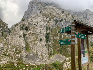
Trailhead to Bulnes with official signboard
2. Puente del Zardo

Wooden Bridge
3. Signboard (Intersection)
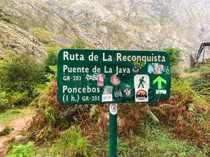
Split for Bulnes de Abajor (lower Bulnes) or Bulnes de Arriba (Castillo or upper Bulnes)
4. Bulnes Funicular

The entry/exit point for the Bulnes Funicular that connects with Poncebos
5. Bulnes de Abajo
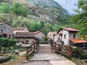
Lower Bulnes village
6. Bulnes de Arriba(El Castillo)

7. Mirador Picu Urriellu (Mirador de Bulnes)
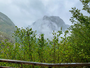
On a clear day, have a view of the most famous peak in the Picos de Europa National Park, Naranjo de Bulnes