Hiking High Tatras | 3 Day Adventure From Poland To Slovakia
If you love discovering gorgeous mountains with jagged peaks, alpine lakes, and rich forests, then you should most definitely add hiking High Tatras Mountains to your bucket list. These jaw-dropping mountains are located in the Tatra National Park, and straddle the south border of Poland and the north of Slovakia. The diversity of these trails range from casual strolls to strenuous adventure hiking that require the assistance of chains and ladders. Throughout the park find decently marked trails, and a convenient system of lodging huts. The rewards of tackling the challenging trails of the high Tatra mountains include stunning views of alpine lakes, steep cliffs, mountain passages, and rewarding peaks.
Don’t these mountains sound magical? In this guide, find out where to base and how to reach this epic National Park. Follow along with a suggested challenging three day itinerary, but there are options for all skill levels to hike and explore the Tatra Mountains, so look for my “alternative routes.” There useful tips on how to use the shelter system and the bet huts to sleep at. Finally, find out how much it costs to tackle a multi-day trek in the High Tatra Mountains,
Grab a great pair of shoes, download an offline map, and let’s explore all you need to know for hiking the High Tatras.
Table of Contents
Disclosure: This is part of my Hikes & Adventures series, which means these treks can be strenuous and challenging. These are my experiences and I am not an expert. Please have all the proper equipment, verify the weather conditions, use professional resources, do your own research, be mindful of constantly changing trail conditions, and take into consideration your own physical abilities and/or limitations. These guides are for entertainment purposes only. Please see my full disclosure for more information here.
- Map & Overview for Hiking High Tatras
- Important Information Before Hiking High Tatras
- What to Pack for Multi-Day Treks in Tatra National Park
- Where to Base for Hiking High Tatras | Zakopane
- Detailed Daily Schedule | Hiking High Tatras
- How to Return to Zakopane from Štrbské Pleso
- Total Cost | Hiking High Tatras for 3 Days
- Final Thoughts | Hiking High Tatras | Poland to Slovakia
Map & Overview for Hiking High Tatras
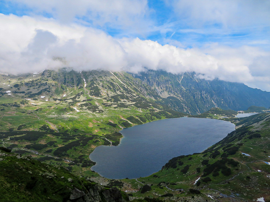
The following map is an example of a diverse 3 day trekking adventure in the High Tatra Mountains. Of course, there are many routes with endless possibilities. This multi-day trek in the Tatra Mountains includes sleeping at the stunning Valley of 5 Lakes, a summit of Poland’s tallest mountain, Rysy, and crosses the border in Slovakia.
- Distance Instructions
High Tatras Hiking Map | 3 Day Adventure Trek From Zakopane
- Distance 22 miles
- Time 8 h 49 min
- Speed 2 mph
- Min altitude 3333 ft
- Peak 8045 ft
- Climb 9521 ft
- Descent 8520 ft
⁉️ If downloading the map, please verify that the map is correct and follows the waypoints. Oftentimes, there are daily updates to the site, map platforms, and other external issues that may cause a bug in downloading. Be mindful that this map is solely for entertainment purposes. Always hike responsibly and respect the mountains by following a no-trace philosophy, avoid hiking alone, be conscious of the weather and personal limitations, and do not stray from the visible trail.
Daily Schedule for Hiking High Tatras
- Zakopane (Kuźnice) to Schronisko PTTK w Dolinie Pięciu Stawów Polskich via Kozia Przełęcz | 7.5 miles | Day 1
- Schronisko PTTK w Dolinie Pięciu Stawów Polskich to Chata pod Rysmi (Slovakia) via Rysy Summit | 9 miles | Day 2
- Chata pod Rysmi to Štrbské Pleso | 5.5 miles | Day 3
⁉️ Safety Note | This route includes tough mountains passes that require the use of chains and ladders. The weather can change fast and oftentimes these tools that help assist can be slippery and hazardous. Please always know your abilities. This following High Tatra hiking route would best suit more experienced hikers.
A Quick Overview for Hiking High Tatras

- 3 Day Trek
- Starts in Zakopane, Poland and Finishes in Štrbské Pleso, Slovakia
- Mileage: 22 miles
- Difficulty: Challenging and Hard for the following Hiking High Tatras route
- Trail Markers: The trails are extremely well marked, especially on the Polish side. Look for painted markers along the trail and frequent informative sign posts.
- Many of these trails have chains and ladders. Please be aware that in the rain and snow these can be slippery and dangerous. Never put yourself in an unsafe situation.
- Utilize the excellent shelter system. The shelters are fully equipped with dorm style beds, a drying room for wet and smelly clothes, sell food and water and have delicious cafeterias, and have for the most part modern toilets.
- Camping is not allowed in the Tatra National Park, it is illegal. Bring your own sleeping bag or liner, so you don’t have to pay for linens at the shelters.
- Gear Essentials
- Good Hiking Shoes with ankle support
- Lightweight Sleeping Bag or Sleeping Liner
- Water Filter
- First-Aid Kit
- Offline Map
- Currency of Euros and Złoty
- More packing tips here
Important Information Before Hiking High Tatras
Before hiking the High Tatra Mountains, know these important numbers and websites.
- Official website for the Polish Side of the Tatra Mountains
- Official website for the Slovakian side of the Tatra Mountains
Unfortunately, the Polish website is only in Polish, but as the park becomes more popular with foreign tourists, this may change.
- Mountain Rescue for Poland +48 601 100 300
- Mountain Rescue for Slovakia +421 52 78 777 11
Pro-Tip | Mountain Rescue is FREE on the Polish side of Tatra National Park. Once you cross into the Slovakian side mountain rescue is A PAID SERVICE.
There is absolutely NO camping allowed in the national park! Don’t waste space in your bag by carrying a tent, so it’s best to hike with a pack around 35 liters.
More Tips & Useful Information for Hiking High Tatras

When passing fellow hikers, shout out the friendly mountain greeting of Cześć (cheh-sh-ch)!
When to Hike
Due to the weather, it’s best to hike in the summer months. Although I hiked in mid-June, there were still many passes and valleys that contained icy snow. Make sure to have emergency blankets just in case and carry trekking poles to help navigate the snowy passes.
To help navigate the rocky trails, it’s best to wear solid hiking boots with ankle supports. Although trail runners are great for light weight hiking, the terrain is best suited for supportive footwear. If planning on hiking the steep trails with chains, I highly suggest boots with solid ankle support.
Sleeping Tips
The Shelters CANNOT refuse you a place to sleep. You will always have a place on the floor if all else fails. Carry a lightweight sleeping bag for this purpose. Also, it will help reduce shelter costs because you won’t need to purchase linens. Make sure at the huts that you charge your phone and devices at the reception area. There are only certain times that reception is open and will monitor your devices.
If planning on crossing borders make sure you are carrying Złoty and Euros! This is extremely important as the shelters in Slovakia will NOT take Złoty.
Some huts have small kitchen facilities, like a sink or a hot water pot, so you can cook your own food. This also helps reduce cots. Make sure to have plenty of water and a filters, as there weren’t many fill up stations in the huts.
What to Pack for Multi-Day Treks in Tatra National Park
Here are some essentials items when planning on hiking High Tatras.
- Sleeping Bag & Liner: These are also essential if you have no set reservations at the mountain huts. This could possibly be your bed for the night, so plan accordingly. Helps with cutting down unnecessary linen expenses.
- Towel: Again, a towel helps with keeping costs down. With warming areas in some of the shelters, a quick-dry towel will most always be dry by the morning.
- First Aid Kit: packed with all the essentials & emergency blankets.
- Water Filter: Hydration is key!
- Rain Gear: light weight & quick dry
- Snacks: Make sure to bring enough snacks for a few days. It’s possible to purchase snacks at the huts, but obviously, they are more expensive in the mountains than in town.
- Battery Pack: This was so important, because some of the huts don’t have any electricity.
- Headlamp: Essential for the shelters and for on the trail. Some shelters offer no electricity at night and the bathroom may be outside.
- Trekking Poles: To help with icy pathways and just overall support on steep mountain trails.
- Waterproof Map & Reliable Offline Map
Supportive ankle footwear is the most important item for hiking High Tatras
Where to Base for Hiking High Tatras | Zakopane


Zakopane, Poland is the perfect gateway village for hiking the High Tatra Mountains. The mountain hamlet is super picturesque, there are lots of shopping options for much needed provisions, and there are a wide range of tour companies and information centers to inquire about the trails.
Make sure to stop by Zakolove, a free information center in the heart of Zakopane. They also speak English and offer simple downloadable maps. Be wary, a lot of the paid tour organizations are disguised as Tourist Information Centers.
If planning on doing some intensive hiking, make sure to buy a waterproof and detailed map. These can be purchased at any of the Tourist Information Centers and entrance points into the Tatra National Park.
Itinerary Planning | 8 of the Best Things to Do in Zakopane, Poland
Of course, after your hike head back to Zakopane to soak your tired muscles in one of the many thermal pools. Why not rejuvenate at the fabulous Chochołowskie Termy? This awesome natural thermal pool is an easy bus ride from Zakopane and feels like a luxury experience, but it won’t break the bank.
Zakopane Sleeping Tip
Need a cozy guest house before or after the Tatra Mountains? Pokoje Gościnne Maria Maka sits a little on the outskirts of Zakopane, but is the perfect place to unwind. This guest house boasts spacious rooms with views of the mighty Tatra mountains and private bathrooms. Within walking distance are tons of traditional restaurants sserving up highland cuisine. The hosts are as warm as the beds. Prices fit in great with those on a budget. Check availability here.
Detailed Daily Schedule | Hiking High Tatras

Here is a daily schedule for adventure seekers looking to have a diverse itinerary. Look for alternative routes for those hikers who don’t feel as comfortable tackling an extreme path.
Skip to | Day 1 | Day 2 | Day 3
Kuźnice, Preferred Entry Point for Hiking High Tatras
Zakopane has a few entry points into the Tatra National Park, but Kuźnice makes an ideal starting point. Reach it by taking a casual 45 minute walk from the downtown area, or hop on any bus in the direction of Kuźnice. If looking to utilize the bus system, check at a tourist information center. Many of the bus drivers don’t speak English, but can usually point you in the right direction. Hotels and hostels will most likely have important bus schedules posted in the lobbies.
Kuźnice is great for day hikers and multi-day trekkers who want to experience the High Tatra Mountains. At this starting point, there is the Kasprowy Wierch cable–car, a restaurant, mini-market, a mountain shop for those last minute items, and a clean bathroom! You must have coins to access the bathroom.
Tatra National Park Entrance Fees | 1 Day Pass: 5 zł ($1.25 USD) | 1 Week Pass: 25 zł ($6.75 USD) | Those spending 2-6 days in the park MUST purchase a week pass
If coming from the Slovakia side, there are NO National Park entrance fees; however, it’s possible to be stopped by Polish park rangers who may ask for proof of purchase.
Day 1 | Zakopane (Kuźnice) to Shelter Valley of 5 Lakes


After purchasing the entry ticket, leave from Kuźnice and hop on the yellow trail of Dolina Jaworzykna. It’s a moderately steep trail, but it’s a great introduction to the mountains and leads to the first mountain hut: Schronisko PTTK Murowaniec
Dolina Jaworzykna Trail | Yellow Trail | 3.25 miles | 2 hours
Soon after, this trail will merge with the blue trail of Przełęcz Między Kopami. Continue on this trail for around 30 minutes or so until you see the busy Shelter Murowaniec.
Schronisko PTTK Murowaniec | Shelter Murowaniec
Shelter Murowaniec is a great place to take a lunch, or at least a quick break. Over the years, this shelter has gotten the reputation of having the best and most delicious food in all of the Tatra Mountains. They offer hearty portions of traditional Polish highland cuisine and a few different soup options. On top of delicious food, they serve up beer, coffee, and their specialty mulled wine to help warm you up on those cold and rainy mountain days. Prices are fairly cheap and reasonable for a hut that is up in the middle of the Tatra Mountains.
Ordering is done via cafeteria style, so order at the main register and then pick up drinks from the bar and food from the cafeteria window. Grab any open seat you can find.
Shelter Murowaniec Logistics | Rooms & Beds for Rent | Cafeteria | Outdoor Seating | Large Dinning Hall | Indoor Bathrooms | Garbage Drop | More info here
Alternative Route for Day Trippers
If you prefer not to sleep in the mountains, head on to the blue trail and visit the lovely alpine lake, Czarny Staw Gąsienicowy. This casual trail is just a little over a mile and is only 30 minutes from the shelter. There is a slight uphill, but nothing extremely steep. Spend some time enjoying the lake. Afterwards, head back down to Zakopane via the same yellow trail you hiked in on.
Allow at least 2 and a half hours to return to the starting point, Kuźnice
Shelter Murowaniec to Shelter Valley of 5 Lakes via Kozia Przełęcz
After a much needed refuel at Shelter Murowaniec, continue on the blue trail to Czarny Staw Gąsienicowy. The blue trail will take about 30 minutes to reach from the shelter. Take the path on the left, so the lake will be on your right side. Follow around the lake until you will see where the trail splits. From the shelter to the split in the trail should take around an hour and a half.
Here, you’ll merge up to the yellow trail toward Kozia Przełęcz.
Kozia Przełęcz | Goat’s Pass


Cross by another small pond, Zmarzły Staw, keep it on your right hand side. It can be tricky, especially since there can still be snow on the trail. This is where an offline map can come in super handy. I do have to credit that the Polish side is extremely well marked.
Kozia Przełęcz literally translates from Polish to the “Goat’s Pass.” This trail is exactly that… one that would only be accessible to the goats. It’s steep, challenging, but so much fun, even in the rain and fog. The pass sits a little over 7,000 feet and includes a thrilling climb using chains and ladders. Soon, you’ll notice that the trail markers lead straight up. Here’s where that chain system comes in, all the way up to the pass and to the way down. There may be some sections where you may have to be on all fours scaling and climbing the mountain (like I did)!
Czarny Staw Gasienicowy to Kozia Przełęcz | Blue Trail to Yellow Trail | 2.75 miles | 2.5 – 4 hours | Take as much time as you need so that you feel safe in this trail section
Safety Notes | Kozia Przełęcz
Kozia Przełęcz is one of the hardest trails in all of Poland. I found that out after I completed it. People actually train for it until they feel comfortable completing it. Many people plunge to their deaths from accidents on this trail. Some steep drop-offs are as high at 1,300 feet. However, like most challenging trails, tackling Kozia Przełęcz was my favorite section of trail in the entire Tatra Mountains.
Personal Experience | When I hiked this trail section it was cold, rainy, and the rocks extremely slippery. But once you hit a certain point, you’ve committed and there really is no turning back. I saw NO ONE on this trail. It was also super foggy, so that might have hindered my ability to see the steep inclines and straight down cliff drops. Keep all of this in mind for safety reasons.
Scaling Down Kozia Przełęcz


If you have a clear day, then you will have some seriously epic views here. On a foggy day, uhhhh, not so much, but it’s still worth it! Once you get to the pass, all you can do is go down via the chains and ladders. It is so important to realize that at the top you merge with a red trail. On the way down, it is important not to lose track of the yellow trail, since the red trail would lead to Zawrat.
Important | As of June 2019, this part of the trail is closed and it is illegal to hike to Zawrat. Part of the mountain actually collapsed, so it is extremely unsafe.
Going down can almost feel more intense than climbing up. There are some sections where you might have to “Spider Man” along the ledge and the chains. I absolutely loved it. You are coming down a 1,300 foot drop-off. Although it’s not a long distance, it’s basically straight down. Don’t forget to breathe! There were some moments I had to stop and breathe and reassure myself that I would reach the bottom. Remember, this trail is INTENSE.
Coming Down Kozia Przełęcz | 1 hour 45 minutes | Don’t lose the yellow trail
Once the chains section is finished, it is still a challenging and narrow path. Chances are the trail can be covered in snow.
Kozia Przełęcz to Shelter


Whew! After climbing down one of the most nail biting paths in the Tatra Mountains, Day 1 is just almost complete! Take a moment to let it sink in that you have just completed one of the most difficult hiking trails in Poland. Now, head to Schronisko PTTK w Dolinie Pięciu Stawów Polskich, or the Shelter of the Valley of 5 Lakes. Reach it via a scenic 40 minute walk on the blue trail. The blue trail feels like a little slice of heaven, since it’s basically flat! In over a little more than a mile, you’ll reach your sleeping base for night.
Schronisko PTTK w Dolinie Pięciu Stawów Polskich | Shelter Valley of the 5 Lakes


The Shelter Valley of the 5 Lakes is awesome. It’s perfectly nestled along the shores of the scenic alpine lakes. When hiking High Tatras, this shelter is a dream. Since there are no roads that lead here, everyone must hike to get here. The check-in is easy and the hut is fully equipped. Try to snag a top bunk, so you can wake up with morning views of the mountains.
Booking Tip | The shelters are always “fully booked” on websites because they leave a certain percentage of beds open for those without reservations. Remember, a shelter can not legally turn you away.
This cozy shelter has a warm and energetic vibe. In the evening, look for locals to be playing traditional Polish Folk Songs on the guitar. Everyone in the cafeteria jovially sings along, while enjoying their delicious meal and beloved company, as they planned their route for the next day. When hiking in the High Tatras, don’t miss sleeping at this shelter.
Shelter Valley of 5 Lakes Logistics | Rooms & Beds for Rent | Cafeteria | Snack Bar | Outdoor Seating | Cozy Dinning Hall | Drying Room | Small Kitchen with Free Hot Water & Sink | Indoor Bathrooms | Garbage Drop | More info here
More Shelter Tips
Food portions are big and fairly priced. Make sure to double check serving times because they do shut down for breaks.
Another amazing feature of this shelter is the drying room! It is a heated room where everyone hangs their items up to dry. Even my soaking wet shoes were wearable by the next morning! Genius!
It’s double the cost to rent sheets for your bed, so be sure to travel with a liner, sleeping bag, or both.
Logistics Hiking Tatra Mountains | Day 1
- Distance: 7.5 miles
- Duration: 7 – 9 hours, dependent on weather, breaks, and fitness level
- Shelter Cost: 35 zł ($9.25 USD)
Day 2 | Shelter Valley of 5 Lakes to Chata pod Rysmi (Slovakia)


Leave the Shelter of the Valley of 5 Lakes on the blue trail that brought you into the shelter. Try to get on the road early. Today is another intensive hike up the summit of Rysy and to cross into the Slovakian side of the High Tatras. After a casual 40 minute hike, merge on to the yellow trail, Szpiglasowa Pass. It wasn’t nearly as intense as Kozia Przełęcz, but this trail does have some chains at the top. These chains are much more manageable compared to the ones from the previous day.
Along this trail section, expect some truly scenic viewpoints of the lakes below. Keep your eyes peeled for the famous Tatra Chamois, an animal that resembles a goat. The alpine scenery is on-point.
Once you reach the pass, add on the 15 minute hike to appreciate the Szpiglasowy Wierch (peak). This peak sits at 7,125 ft.
Szpiglasowa Przełęcz | Yellow Trail | 2.5 miles | 2 hours
Coming Down Szpiglasowa Przełęcz

Coming Down from Szpiglasowy Przełęcz is relatively easy. Catch some amazing views of the most popular lake Morskie Oko and Czarny Staw pod Rysami sitting above it. Hiking this trail will lead you to the busiest and most popular mountain hut, Schronisko PTTK Morskie Oko.
Szpiglasowa Przełęcz to Morski Oko | Yellow Trail | 2.5 miles | 2 hours
Alternative Route to Morski Oko
Leave the Shelter Valley of 5 Lakes and take the blue trail to Morski Oko. The Blue trail to Morski Oko is only 2.5 miles and mostly downhill. Expect this trail to take one hour and 45 minutes. A lot of people used this as an alternative of going up the yellow trail of Szpiglasowy Przełęcz.
Morskie Oko is the most popular trail the Tatra mountains and it’s possible to take the casual 5 miles stroll along the paved road to Palenica Białczańska. From there, buses run frequently back to Zakopane.
Morskie Oko
This is the most popular lake to visit in the Tatra National Park. This is a popular spot for those hiking the High Tatras, or visitors day tripping from Zakopane.
Schronisko PTTK Morskie Oko | Shelter Morskie Oko
Shelter Morski Oko is super busy and is usually jammed pack full of people.
Shelter Morski Oko | Rooms & Beds for Rent | Full Service Restaurant | Cafeteria & Snack Bar | Outdoor Seating & Picnic Area | Indoor Dinning Hall | Indoor Bathrooms | Garbage Drop | More info here
Alternative Route for Day Trippers
Morski Oko is the most popular day trip in the Tatra Mountains. Also, it’s the most convenient route. Morskie Oko is so busy because it is super easy to reach as a day trip from Zakopane. Take a bus to Palenica Białczańska and follow the red trail to the lake. There are horse and carriages along the paved pathway, but please take in consideration the well-being on the animals. Do they looked loved and well taken care of?
Palenica Białczańska to Morski Oko | Red Trail | 5 miles | 2 hours each way | This trail is used by horses, strollers, and bikes
Morskie Oko to Rysy Summit


Leave the Shelter of Morski Oko and follow the red trail around the lake up to Czarny Staw pod Rysami, the alpine lake above it that sits over 5,000 feet. If the shelter is to your back, keep to the lefthand side of the lake. After 20 minutes, start to make your ascent to the next lake. This trail is still pretty busy, but as you move further away from the shelter, the traffic begins to thin out. Plan for this section of the trail to take around 45 minutes.
Czarny Staw pod Rysami is a great place to take a quick break before you start trekking up to Rysy. Continue along on the red trail. There is another chain section as you climb, but I found myself not relying on them during this duration of the trek. Reaching the summit of Rysy is no joke and you should plan at least 3.5 hours.
Rysy is a straight uphill battle and the ascent from Czarny Staw pod Rysami is around 3,300 feet. The biggest opponent here is time. Make sure you allow enough time to reach the top. Once you hit the summit there is still a little jaunt to reach the next mountain hut.
Czarny Staw pod Rysami to Rysy | Red Trail | 3.5 hours | 3,300 ft ascent
Want to Hike Rysy with a Guide?
If you still want to challenge yourself and summit Rysy, there are small tour groups that leave from Zakopane. They will help you up the mountain and get you back safe and sound. I didn’t use these groups, but I did pass one on the way down. There were two guides for a small group of four hikers. Each group member had a helmet and the proper safety gear. If you want to summit a mountain and never have before, this may be a great option for you!
Rysy Summit


Once you reach Rysy’s summit, you are at the highest point you can hike to in the Tatra Mountains without hiring a guide. The summit sits just shy of 8,200 feet. There were a few people up there and even cell phone service! Once you begin the descent down from the summit, you’ll be hiking over the border into Slovakia!
Rysy Summit to Chata pod Rysmi

There’s still a little bit more of a trek until reaching the shelter, but it’s the home stretch from here. On the way down from the summit, check out those epic views of the lakes below. Keep following the red trail.
It’s another 45 minutes or so before you arrive at Chata pod Rysmi, the highest shelter you can sleep in while hiking the Tatra Mountains. This trail section has a lot of loose large stones. Take caution with tired legs walking this last section.
Rysy Summit to Shelter pod Rysmi | Red Trail | 45 minutes | Welcome to Slovakia!
A Note of Caution | The Slovakian side is not as well marked as the Polish side. Also, remember that on the Slovakian side of park, mountain rescue is not free.
Chata pod Rysmi | Cottage pod Rysmi


The prices here were a little steep compared to the Polish side. A bed in a shared room is 20€. It is the same price whether you get a bed or sleep on the floor. Remember, you are in Slovakia!
You will need Euros to eat and sleep here.
There is no shower here, but everyone said it offers the best bathroom in all of the Tatra Mountains. It’s about a 3 minute walk from the shelter to the bathroom, but can you imagine a better view while relieving yourself?
There is no electricity to charge your personal items here either, so make sure you have a battery pack. Lights go off at 9:00 PM and then they bring out the old-fashioned lanterns. It was a pretty cool experience. Make sure you bring a headlamp for getting to and from the bathroom and around the hut.
Cottage pod Rysmi | Beds in Shared Rooms | Limited Restaurant | Snacks & Beverages | Outdoor Seating & Picnic Area | The Mountain’s most stunning bathroom | Sleep at 7382 feet | Neat Mountain Hut Ambiance | No Garbage Drop | More info here
Booking Tip | By law they have to offer you a sleeping space on the floor if they are fully booked. The shelter was completely booked up, but if people who reserved a space don’t show up by 9 PM, they are considered void. So you must wait around until 9 PM to figure out if you have a bed or not. If the reservations don’t show, Congrats! You won’t have to sleep on the floor. I actually did this. I waited until 9 pm and was happily moved to a bed.
Logistics Hiking Tatra Mountains | Day 2
- Distance: 9 miles
- Duration: 9 – 11 hours
- Shelter Cost: 20€ ($24.25 USD)
Day 3 | Chata pod Rysmi to Štrbské Pleso


On Day 3 it’s all downhill from here! Leave before 8 am from Chanta pod Rysmi so you can watch the porters, men carry kegs and all the supplies up the mountain on their backs.
The red trail continues all the way down to the popular lake on the Slovakia side, Popradské Pleso. This is an easy downhill hike that will pass by Žabie plesá, or Lake Zabie. There is only a small section of chains on the way down, but they also have a ladder, which felt like it served no purpose. This last trail had the easiest section of chains in the Tatra Mountains.
This easy downhill stroll should take around an hour and half if you don’t stop.
Once at Žabí Creek, look for a crossroads near a bridge. This is where you merge on to the blue trail in the direction of Popradské Pleso. It’s an easy 30 minute walk to reach Popradské Pleso.
Chanta pod Rysmi to Popradské Pleso | Red Trail, merge onto Blue Trail at Žabi Creek | 2 – 3 hours
Popradské Pleso

At this sparking alpine lake, there are two large shelters. Both offer full menus and snacks. Truth be told, I stopped for a dessert here! Hikers compare Popradské Pleso on the Slovakia side to Morskie Oko, on the Polish side.
From Popradské Pleso there are three different routes to get to the village Štrbské Pleso. This itinerary follows the red trail. The red trail has beautiful views, but was very crowded. Štrbské Pleso is where you catch the electric train out of the Tatra Mountains.
Popradské Pleso to Štrbské Pleso | Red Trail | 3 miles | 1 hour
Before arrival into the town, there will be plenty of little “shops” that sell last minute clothes, souvenirs, maps, and even some places to grab a drink or get an ice cream cone. Štrbské Pleso is a great base for hiking High Tatras from the Slovakian side.
Logistics Hiking Tatra Mountains | Day 3
- Distance: 5.5 miles
- Duration: 3 – 4 hours
How to Return to Zakopane from Štrbské Pleso

There is an electric train that runs from Štrbské Pleso to Tatranská Lomnica. It’s a scenic route that winds through the gorgeous mountain passes. Be warned, this train can be packed and some days it is hard to find a seat. It also moves pretty slowly, but it is super Eco-friendly!
First buy your ticket online, or at the ticket station. The train line is number 183 and tickets are sold upstairs. All trains transfer at Stary Smokovec. Make sure not to miss your transfer! Transfer across the tracks and hop on the train for Tatranská Lomnica. Kick back, relax, and enjoy mother nature’s show out your window.
Electric Train Logistics | Cost: 2€ | Duration: 1 – 2 hours, depending on which train | Transfer at Stary Smokove | Purchase tickets online here
For the complete time table of train 183, click here
Bus from Tatranská Lomnica
Once you reach Tatranská Lomnica, you will need to catch the bus back to Zakopane. It is a fairly small town and most everything important surrounds the train station. There is an extremely helpful tourist information center about a three minute walk from where the electric train drops. The Tourist Information center is your best bet to check and confirm bus tables. They also speak English.
Local Tip | Looking for some great traditional Slovakian food? Try Reštaurácia Stará mama. They serve up some awesome local cuisine and an extensive Slovakian wine list. Prices were fair and portions were large.
Bus Logistics
The bus station is also close, but there is not an actual station. The buses pull into the parking lot and you must purchase your ticket on the bus, or online here. Tickets range from 18-22 zł, depending on the timetable.
It is essential to double check the timetables, because they run on high and low season schedules. Buses run to Zakopane 4 – 5 times a day.
Bus Logistics Tatranská Lomnica to Zakopane | Cost: 18-22 zł | Duration: 1 hour 15 minutes | Verify the timetable here | Purchase tickets online here
Alternative Routes
It is possible to day trip from Zakopane to the Slovakia side. Of course, Tatranská Lomnica is the gateway to reach Slovakia from Poland. During the summer months, there are only two morning buses from Zakopane to here. Buses leave from Zakopane Main Station Stand Number 11.
Total Cost | Hiking High Tatras for 3 Days
So, how much does this itinerary of hiking High Tatras cost? Well, lets break it down. Keep in mind that you will need Polish currency and the Euro.
For simplicity, I’ve converted all expenses to the Polish złoty.
Prices on the table are rounded to the nearest 25¢
| Expense | Złoty (zł) | USD ($) |
| Tatra National Park Entrance Ticket (1 week) | 25 zł | $6.75 |
| Sleeping @ Shelter Valley of 5 Lakes (Night 1) | 35 zł | $9.25 |
| Breakfast @ Shelter Valley of 5 Lakes (Day 2) | 15 zł | $4 |
| Sleeping @ Chata pod Rysmi (Night 2) | 91 zł | $24.50 |
| Dinner @ Chata pod Rysmi (Night 2) | 40 zł | $10.75 |
| Snack @ Horský hotel Popradské pleso (Day 3) | 15 zł | $4 |
| Electic Train Ticket to Tatranská Lomnica | 9 zł | $2.5 |
| Lunch @ Stara Mama | 60 zł | $16 |
| Bus Ticket to Zakopane | 20 zł | $5.25 |
| Total | 310 zł | $82.75 |
In total, this fun adventure of hiking High Tatras cost me $82.75!
Of course, it’s possible to lower expenses by not eating at the shelters and packing in your own food. Remember, there is no camping in the Tatra National Park, so you must sleep in the shelters, or do only day trips.
Final Thoughts | Hiking High Tatras | Poland to Slovakia
In short, hiking the High Tatras has been one of my favorite spots for trekking in all of Europe. The mountain range is so diverse and it’s possible to discover two very distinct regions, the High and Low Tatras.
The High Tatras boast some seriously challenging alpine trails with epic views, shimmering glacial lakes, and beautiful forests. Connecting these lovely spots are strenuous mountain passes, towering mountains peaks, and an extensive, yet cultural shelter system. It’s totally worth the effort to tackle a multi-day trek and go hiking through the High Tatra Mountains. Seriously, don’t miss hiking in this gorgeous and underrated mountain range.
Have you explored this national park via hiking High Tatras? Did you find this itinerary useful? Am I missing something extremely important? How many days did you spend hiking High Tatras? Are the Tatra Mountains now on your bucket list? Let me know in the comments below?


Disclaimer: There’s a chance this post contains affiliate links, and I receive a small (but grateful) portion of the sale. There’s no extra cost to you, and I only promote things that I use and love.


Is there any pass port control along the way?
There is no passport control from Poland to Slovakia since they are both part of the EU (Schengen)
I’m trying to decide if I’m up to this hike. I would like to hike from Kuźnice to Štrbské Pleso then get a shuttle down to Budapest. I’m a little concerned about the hike over Kozia Przełęcz. I don’t want to get there and chicken out or worse get hurt. I have gone up Half Dome in Yosemite and I’ve done the Tridentina via ferrata in the Dolomites (with a guide and clipped in). Any thoughts on if I’d be up to the Kozia Przełęcz? Is there an easier pass (ie. Przełęcz Zawrat) if we want to get to the Schronisko Dolinie Pięciu Stawów from Kuźnice?
Hey Marc-
The Kozia path is quite a challenge, which I didn’t realize until after I hiked it. At the time I visited, Zawrat was closed for some time due to rockslides as the trail is very steep and the path very narrow and might be more challenging than the Kozia. I’m unsure if Zawrat uses chains or if it is open yet. I think it’s best to check in the visitor’s center in Zakopane, they are super helpful.
Alternatively, you could hike from Morskie Oko over to the Schronisko Dolinie Pięciu Stawów shelter and just loop back and continue on the same route. The section of the trail is pleasant and you could still finish comfortably in three days.
I haven’t done Half Dome or the Dolomites yet, so I can’t give a fair comparison. Either route you chose, hiking in the High Tatras is an unforgettable experience. I can’t wait to get back. Happy trekking 🥾
Thank you for the kind reply. I’m motivated to do the route you hiked but the alternate route from Morskie Oko looks like a good, easier, alternative.
Just for kicks, I inquired via email about room availability at the huts. As you had stated, they are fully booked. I also asked about sleeping on the floor if we show up without reservations and I got this terse reply:
“Our refuge does not provide accommodation on the floor. Waiting out the night in the shelter will be possible only in exceptional situations, endangering the safety of tourists. Please plan your trips carefully”
It appears they aren’t that fond of people simply showing up without reservations. You were clear in your article that they cannot turn anyone away. Did they give you any hassles about staying without a reservation? I hate to be that unruly tourist not playing by the rules or worse yet the dumb tourist who gets stuck in the mountains without a place to sleep. Just looking for a little reassurance before I head up without a tent.
Thank you!
Hey Marc-
I hiked in the Tatras Pre-Covid, so of course, the world and standards have changed. However, you are not allowed to camp or even bring a tent into the Tatras, so it is my understanding that the mountain huts can’t turn you away for safety and liability reasons.
I was a solo hiker, so I had no problems showing up without a reservation, but I also hiked in the late spring, so it was not during the peak of the busy season. From my understanding from a friend who lives in Poland and hikes here often is that they “don’t book out all the rooms,” even though they appear full so that they have some flexibility with walk-ins. Also, it’s possible that people don’t show up for their reservations. That’s how I was able to secure a bed in the Rysy Hut. I had to wait out in the “main common space” until 9 p.m.(when the reservations are no longer valid) and then I was finally given a bed. This was the case for three others, too.
The Polish are super hospitable, so I never got hassled.
Of course, with hiking there are always some gambles and unseen circumstances. I have simply written to the best of my current knowledge and shared my personal experience.
Thank you for compiling this Megs! We are thinking of doing this in August.
Awesome! It’s a great hike and the weather should be incredible! Enjoy 🥾
Hi Megs, this is a great summary!
I am planning a trip for September to hike in Austria and then in the High Tatras. I am hoping to go in the opposite direction and hike from Slovakia into Poland. I am an experienced and confident hiker and plan to the trip solo. I hike solo often in Canada and have hiked in the Himalayas, Patagonia, the Andes, & the Dolomites and have always felt safe, but I don’t know anyone who has hiked the High Tatras so I’d love to hear how you felt hiking as a solo female there? Also, do you think this route would be reasonable in reverse? I’ve also looked at options going from Tatranska Lomnica to Rysy and into Poland. Thanks for any input you can share!
Hey Ashley!
Thanks for reading and reaching out. I hiked the trails in the Tatras as a solo female traveler and found them to be quite safe and from your adventures it sounds like we have trekked many similar trails! Of course, as you are an experience hiker, just make sure to tell someone your route, carry the proper gear, and be mindful of the weather. The trails are extremely well-marked and trotted, the people extremely friendly, and the mountain huts are cozy, but of course in the mountains, anything can happen.
I think you will be fine going in reverse, but if you opt for the Goat Trail (Kozia Przełęcz) the section is very narrow and offers chains and ladders. I didn’t encounter any hikers on this section, except at the end, and we were moving in the same direction. Remember that the rescue services in Poland are free, while in Slovakia you will be charged. From my experience, the Slovakia side is a little less maintained than the Polish side, but this was a few years ago and most hikers in the huts agreed.
My one regret was not exploring the Lower Tatras on the Polish side, which are said to be quite different with lovely forests.
Happy Hiking and let me know how your trip goes! 🥾
Megs
Thank you for the response! I will let you know how it goes 🙂
Hi Ashley! Curious if you tried this! I am also looking to go the opposite direction 🙂
Hi Megs!
Wanted to say thanks for sharing your experience!
Just finished my own jurney in The Tatras following your route.
It was a great balance of difficulty and beauty on the Trail.
Kozia Przełęcz especially left me hungry for more and now I can’t wait to go back and finish all of Orla Perć!
Good luck on your travels!
Thanks Ashley that is fantastic! Thanks for sharing. 🙂
Happy Hiking!
Megs
Hi,
I’m looking to follow this route in the Summer! Is there any easy way to avoid the Kozia but still stay on roughly the same route ?
Thanks for your help!
Joe
Hey Joe-
Sorry for the delayed response. It would be easy to start at Morskie Oko and and walk to the Valley of 5 Lakes and to Czarny Staw pod Rysami. The summit of Rysy could also be reached. A lot of people also start their Tatras adventures in Slovakia at Štrbské Pleso, which has tons of hiking trails.
Did you find an alternative route that worked? I know that the low Tatras in Poland are supposed to be lovely, too.
Happy hiking,
Megs
Megs,
Great blog / description / detail. I appreciate all the effort (and it’s obvious that was a LOT of effort) that went into writing this hugely detailed description and pics. We’re hoping to do a similar trek based on your description, this June. Your piece has given us the confidence, even though you’ve clearly explained how hard the Goat Track might be.
Thanks for sharing this.
Jim
Thanks Jim!
I really did love hiking in the High Tatras. If you have an extra day, I suggest spending time on the trails in Slovakia, which were extremely different.
Happy Hiking,
Megs
I might have done Kozia Przełęcz when I was a teen, but honestly I don’t remember. I do remember the chains and the terror of the possibility of falling 🙂 On another hand, I am dreaming of seeing the valley of 5 lakes again. Such a gorgeous place!
Wow! Yes, this is a memorable hike! I would love to get back and spend more time in the Tatra Mountains!