How To Hike the Epic Ausangate Trek Without A Guide | 6 Days
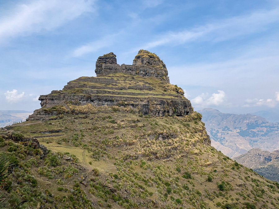
The mighty mountain of Ausangate looms off in the distance and can be seen from the Imperial City of Cusco. This incredible mountain is home to one of Peru’s most diverse and incredible multi-day circuit hikes: the Ausangate trek.
The Ausangate trek is a high-altitude challenging excursion and the entire hike never dips below 14,000 feet. Although multiple tour companies offer their services, experienced and confident hikers can enjoy the Ausangate trek without a guide.
The most common Ausangate trek route is a 6 day circuit. The Ausangate trek over six days can include a day trip out to the wildly popular Rainbow Mountain.
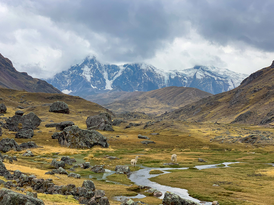
The Ausangate trek is remote. Be prepared to walk en route among hundreds of alpacas and llamas. If you’re lucky, spot wild vicuñas roaming across the alpine landscape. There are a plethora of viscachas, a high alpine rodent, bouncing jovially along the path.
Appreciate the diverse glacial peaked mountains and walk right next to vivid blue alpine lakes.
Completing the Ausangate trek without a guide is difficult, but feasible for hikers who have properly acclimated, have above-average trail knowledge and experience, and come prepared both physically and mentally.
In this Ausangate trek guide, find an Ausangate trek map, how to reach the trailhead, helpful tips and tricks for hiking the Ausangate Rainbow Mountain out and back trail, and the estimated cost of the Ausangate trek.
This complete guide is to help adventurous hikers plan and prepare for the Ausangate trek without a guide.
Table of Contents
Disclosure: This is part of my Hikes & Adventures series, which means these treks can be strenuous and challenging. These are my experiences and I am not an expert. Please have all the proper equipment, verify the weather conditions, use professional resources, do your own research, be mindful of constantly changing trail conditions, and take into consideration your own physical abilities and/or limitations. These guides are for entertainment purposes only. Please see my full disclosure for more information here.
- Ausangate Trek Map
- Planning Tips & FAQ | Ausangate Trek Without a Guide
- How to Reach Ausangate from Cusco
- Detailed Daily Schedule | Ausangate Trek Without a Guide
- How to Return to Cusco
- Total Cost of Ausangate Trek Without a Guide
- Final Thoughts | Ausangate Trek Without a Guide
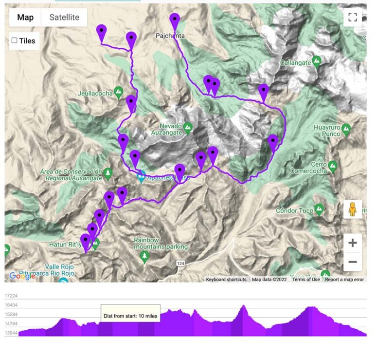
Ausangate Trek Map
Keep in mind, there are many different options and alternative paths for hiking the Ausangate trek without a guide.
Suggested Trekking Itinerary of Ausangate Trek Without a Guide
This daily schedule of the Ausangate trek is a loose guide, as there are multiple routes that can affect the daily mileage.
Mileage distances are rounded to the nearest quarter of a mile.
- Day 1 | Upis – Wild Campsite | 8.5 miles
- Day 2 | Wild Campsite to Shelter near Laguna Ausangate | 4.5 miles
- Day 3 | Shelter to Campsite by Rainbow Mountain | 6 miles
- Rainbow Mountain & Red Valley | Add a minimum of 3 miles round-trip from campsite
- Day 4 | Campsite by Rainbow Mountain to Machuraccay Lodge | 8.75 miles
- Day 5 | Machuraccay Lodge to Campsite near Lakes before Pacchanta | 10.5 miles
- Day 6 | Lake Campsite to Pacchanta | 4 miles
Quick Overview of the Ausangate Trek Without a Guide

- Loop Trail
- Add-On Out & Back Trail: Rainbow Mountain (Vinicunca) and the Red Valley (Valle Rojo)
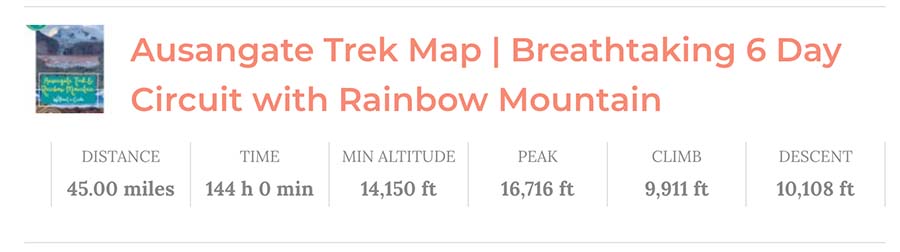
- Mileage: Around 45 Miles, depending on route
- Difficulty: Extremely Difficult
- The Ausangate trek without a guide is extremely difficult due to the trail’s remoteness, altitude, and being unmarked. Additionally, the weight of carrying all your gear and food for at least 5 days
- This high-altitude trek in Peru never dips below 14,150 feet (4,000m)
- The weather can change fast at this altitude and there are risks associated with doing the trek guided or not. NEVER HIKE ALONE
- Duration: 5 – 7 Days
- Trail Markers: There is some signage along the route. Many of the mountain passes have signage with the altitude and the name of the pass. The path is pretty straightforward; however, knowledge of how to follow an offline map is essential.
- Basic covered shelters can be found along the route, many have basic facilities like outhouses and running water.
- DO NOT RELY ON THE SHELTERS as they are often closed, can be torn down, or are owned by local tour groups
- Ausangate Trek Gear Essentials
- Tent, I carry and love Nemo tents
- Durable high ankle hiking boots, Salomons are excellent and GORE-TEX is best
- Sleeping Bag for Cold Weather, I carried no less than a 15° Sleeping Bag, and a sleeping pad
- Trekking Poles
- Water Filter Kit
- Cooking Stove with enough fuel and cooking supplies for at least 5 days
- Portable Battery Packs for chargers (kept warm at night)
- Headlamp
- First-Aid Kit with at least one Emergency Blanket per person
- Layered clothing for all weather conditions, including warm gear for nights
- Coca leaves for altitude sickness and gifts
- Offline Ausangate trek map
- My Complete Peru Packing List for Multi-Day Treks
➯ Hey… don’t forget your Travel Insurance! I love SafetyWing
Planning Tips & FAQ | Ausangate Trek Without a Guide

These are helpful tips when planning the multi-day Ausangate Trek without a guide.
Below, find the best time to complete the Ausangate trek, safety notes, and more useful information. Remember, completing the Ausangate trek without a guide, is best suited for experienced hikers who feel confident in their abilities and skills.
Of course, there is always the possibility to hike the Ausangate trek with a guide and organized tour group.
Jump to | Safety Notes | Altitude Ausangate Trek | Do I need a Tent? | Hike with a Buddy | Dogs | Inca Sites on the Ausangate Trek? | Tips from a Local | Ausangate Trek Tours
When is the Best Time to Hike the Ausangate Trek Without a Guide?
The most popular time to hike Ausangate is between the months of April to October. Peru has two main seasons, dry and rainy. In general, dry season is from May to October, while rainy season is from November until April.
Remember, at these extreme altitudes, the weather is wild, volatile, and can change in an instant. In minutes, sunny skies can be replaced by rain clouds with lightning bolts. Around the powerful mountain, the weather is completely unpredictable.
We checked the weather a few days before, but it’s so hard to predict and is one of the biggest risks if hiking the Ausangate trek without a guide. It’s best to plan on an extra cushion day or two, if the weather changes and is bad.
Peru Dry Season
During the dry season, there is less rain. However, during dry season in Peru the nights are much colder than the rainy season. With cold nights during the dry season, sections of the trail can be covered in snow. Even with the shoulder months, it’s possible to have some of the passes covered in snow up to your knees.
During Peru’s dry season, water will be more scarce. Keep this is mind for the second day of the Ausangate trek. Make sure to carry enough water. Water can be extra hard to come by during the dry season
With that being said, we did the complete Ausangate trek without a guide the last week of September and had amazing weather. The nights were a little warmer and we had snow some days, but never enough where we lost the trail. In the morning at Rainbow Mountain we had fresh snow making the views more dramatic. Shoulder season can be a great time to complete the Ausangate trek.
Peru Rainy Season
During the peak of rainy season, the trekking route will be extremely muddy and not as enjoyable. It is not advised to try any multi-day treks in Peru during rainy season. Mudslides and rockslides are quite common.
If thinking about doing the Ausangate trek during the rainy season, consult with a professional travel agency.
Safety Notes for Hiking the Ausangate Trek Without a Guide

This incredible multi-day Ausangate trek is for adventure seekers looking to enjoy one of Peru’s most scenic hikes, which continues to tops the list of the most beautiful treks in the entire world. With the beauty comes risk. This Peru trek is a challenge!
There are very few “villages” once leaving the tiny community of Upis. Make sure to pack amble supplies for the amount of days you’ll be on the trail, including water sources. These villages are usually just a shepherd house or two and are oftentimes empty.
Many of the shelters laid abandoned as well, but the water source usually worked.
The Andes Mountains are beautiful, but with the beauty comes risk. The Ausangate trek without a guide is not a great for “first time hikers” to go out and explore on their own. Even experienced hikers should never hike alone. Always tell people where and when you are hiking with an outline itinerary.
➜ More Details | Cusco Trekking Tips & Best Multi-Day Cusco Treks
Leave No Trace
Always respect the mountains by following a “leave no trace” philosophy. This means packing out everything you bring, staying on the designated trails, and carrying out or burying all natural human waste. I make sure to bring a biodegradable natural soap like Dr. Bronner’s.
The mountains in Peru offer so much healing and beauty, we should respect Mother Nature by leaving her better than we found her. The Ausangate trek pass through local communities, so we must also respect the Indigenous land owners who allow us passage.
What is the Altitude of Ausangate Trek Like?
The altitude of the Ausangate trek is insane. Remember, this trek never drops below 14,000 feet!
Many of the passes are grueling and top out at over 16,000 feet. The mountains are Apus, or Gods, to the Indigenous, so go in with the mindset of respecting them. By the way, the mighty mountain of Ausangate is a staggering 20,945 feet (6,384 m).
Acclimation is key when preparing for the Ausangate trek without a guide. Make sure to take ample time to acclimate in Cusco, especially if attempting the Ausangate trek without a guide. Altitude sickness can be deadly.
☛ Psst… Here are over 43+ Things to Do in Cusco while you acclimate
Also, avoid coffee! I drank coffee the first morning and got sick. Instead, drink coca tea from coca leaves to help with the altitude, warm up the body, and have natural caffiene. It’s also a common practice to leave “offerings” to the mountains, for safe passage and gratitude.
Do I Need a Tent for the Ausangate Trek?

Yes, the Ausangate trek is remote and there is really no way to get around not having a tent. It is possible to rent a tent, but those without proper gear should opt for an organized Ausangate trek with a guide.
There are some covered shelters along the route, but it’s best to not rely on them. As of recently, many of these shelters are disappearing along the Ausangate trek route. Wild camping is becoming more utilized.
There are some more shelter-like structures along the route, but only one was open. It is a safety risk to simply rely on covered shelters and safe houses. You must carry a tent for the Ausangate trek.
➜ Nemo makes excellent lightweight tents
Always Hike in Peru with a Buddy

Hike with friends and carry the proper gear. At these extreme elevations, the weather can be a beast and storms roll in fast. It’s essential to hike with at least one other person for safety risks. The Ausangate trek is extremely remote so never venture into the mountains alone.
Need a hiking buddy or up to date trail advice? Check out Hike Club Cusco
Dogs on the Ausangate Trek
It’s worth a quick mention that some of the shepherd dogs can be, or can appear aggressive along the way. A majority of them are owned by the women who walk the mountains with their sheep and alpacas.
For dogs that are bold, pick up a stone, or at least pretend to grab one. This usually deters them, and keeps them at a safe distance to pass.
Trekking Poles can come in handy to help keep aggressive dogs at bay.
Overall, we didn’t encounter any overly aggressive dogs, but they are worth a mention, especially for those hikers completing the Ausangate trek without a guide.
Are Inca Sites on the Ausangate Trek?
Unlike most popular treks near Cusco, like Choquequirao trek, the Classic Inca Trail to Machu Picchu, and Waqrapukara trek, the Ausangate trek does not contain any Inca ruins. However, the Apu Ausangate is considered one of the most revered God deities in the Cuzco region. Apus is the Quechua term for the mighty Mountain Gods.
Ausangate Mountain ranks as one of the tallest mountain in Peru at a staggering elevation of 20,945 feet (6,384 m). It is the tallest mountain in the Cusco region.
There are discrepancies, but Ausangate is either the 5th to the 7th tallest mountain in Peru (Holy Wow)! No matter where it sits in the rankings, Apu Ausangate is impressive and one of the most incredible natural landmarks in Peru.
Every year there is the famous pilgrimage to the Ausangate region, Qoyllur Rit’i. The festival takes place close to Mount Sinakara and the route is considered one of the most sacred pilgrimages in the Andes Mountains. The festival is celebrated near the end of May to June, but will change, as it coincides with the full moon.
Our ancestral roots across the globe have always been intrigued with the sky, and this festival is believed to pre-date the Incas, as it pays respects to the seasonal disappearance of the Pleiades Constellation.
So while the Ausangate trek contains no Inca ruins or notable sites, the entire region is considered one of the most sacred places to the Indigenous People of Peru.
☛ Peru Travel Tip | There are tons of Inca sites in the unmissable Sacred Valley Peru
More Helpful Tips from a Local | Ausangate Trek Without a Guide

A local man at the beginning of the Ausangate trek warned us to keep our gear close and to sleep with our backpacks inside of our tents. We never had an issue but appreciated and respected his warnings.
Always be cautious of leaving behind gear, especially if doing the Rainbow Mountain as an out-and-back day trip.
Another wildcard factor about hiking the Ausangate trek without a guide is the entrance fees, camping fees, and land fees. These expenses can be hit or miss.
While you may not have to pay an entrance fee to the park or the main sites, some locals may ask for a small fee to camp at the shelters, or to walk along certain trails. These rates can range from free to 15 soles per tent, it all depends. We were not asked to pay a camping fee for the entire trek.
Be mindful that shelters can be owned by local tour groups. For example, AB Expeditions owns the shelters near Laguna Pucacocha and the shelters close to Rainbow Mountain, so fees are enforced to use the shelters. AB Expeditions offers Ausangate tours, so their groups have first access to the shelters.
➜ Contact AB Expeditions here about shelter fees
As the Ausangate trek is becoming more popular, it’s worth a note that it is becoming more common for local people to ask for entrance fees to walk along certain sections of the trail. It’s best to carry small notes of the Peruvian currency of Soles (PEN).
One of the best pieces of advice I can offer is to travel with extra small bags of coca leaves. These leaves can be used as gifts for the people of the communities and are a must when asking for photos. Pack a few extra small bags to share as gifts.
Remember, many of these villagers speak limited Spanish or no Spanish at all. It may be best to learn a few Quechua words. Always ask for permission before taking photos.
Organized Ausangate Trek Tours
Alternatively, there are many Ausangate Trek Tour options. This trek is beautiful and many hikers depart from Cusco on Ausangate tours ranging from a day trip to a diverse number of multi-day treks.
If worried or questioning the many risk factors of the Ausangate trek, such as the extreme altitude, intensity, route, proper gear, or your physical capabilities, always opt for a guided tour.
How to Reach Ausangate Trailhead from Cusco

Public buses run from Cusco to Tinki, which is where the trailhead for Ausangate begins.
Cusco to Tinki Bus Logistics | Cost: 15 PEN ($4 USD) | Duration: 3 hours | Bus Schedule: Start at 5 am, depart twice an hour, every half hour | Buses depart near the Coliseo Cerrado Casa in Cusco
Important Bus Info | If there are only a few people departing at Tinki, the buses final stop may be in the nearby village of Ocongate. If this is the case, the bus drivers will apply the already paid bus fare to a taxi. The bus driver will pay the taxi to drop you in Tinki.
Once in Tinki, the best option is to take a taxi from the plaza to the “trailhead” of the Ausangate trek. The official trail begins just past the tiny village of Upis, but almost all the taxis refuse to drive there.
There are two sections of the village Upis and the taxis usually drops in between them. They will drop “as close as they can” to Upis, which means at least a 3 mile walk (over 5 km) on a gravel road to reach the official trailhead.
Taxi Tinki to Upis Logistics | Cost: 30 PEN ($8 USD) for the entire car | Duration: 30 minutes | Taxis usually drop 3 miles from the official trailhead, between the two sections of the village of Upis
For another 20 PEN the driver, they may drop you closer to the further Upis. Make sure to negotiate this before entering the car.
Along the road from Tinki to Upis is where the locals collect the individual entrance fee of 10 PEN for the Ausangate trek. Some days, there is no one collecting the fee.
Detailed Daily Schedule | Ausangate Trek Without a Guide
Here’s a basic schedule of how to hike the Ausangate trek without a guide. This is an overview of the Ausangate trek in 6 days. Included find Ausangate trek hints, tips, and good to know tidbits.
Day 1 | Upis to Campsite Night 1


Try to catch the first bus out of Cusco. Remember, the bus departs Cusco at 5 am. After the three hour bus ride, arrive in the village of Tinki. From here, negotiate with a taxi driver for the cost and drop-off location to Upis. Chances are the driver won’t drop in the actual village of Upis, but rather over 3 miles out on a dirt road. Be prepared to pay the entrance fee along the road.
Ausangate Trek Entrance Fee | Cost: 10 PEN per person ($2.75) | Some days people collect the entrance fee, other days they don’t, you may be asked to pay later on during the trek
In Upis, there are modest hot springs. It’s nice to soak here for an hour and appreciate those mighty mountain views. Take caution and don’t relax your muscles too much, there is still a pass to hike through and few miles to walk.
After a quick dip, continue to the trailhead. It is marked clearly with a blue and white sign. Continue to pass through the Abra Arapa Pass (14,927 feet). Keep your eyes peeled for wild vicuña, (relatives of the llama).


After the pass, the landscape changes a bit and there will be a few beautiful alpine lakes. If you got a later start (like we did), along the lakes is a great place to camp, otherwise you can push for the main lake of Hatun Pucacocha that you’ll pass by on Day 2. Remember the shelter at Laguna Pucacocha are owned by AB Expeditions.
I loved our campsite on night 1. Find a fresh water source at the river. Look for the blue mirador sign and wood shelter. This lake is a great place to camp, with running water and epic views.
Hiking Logistics | Day 1
- Distance: 8.5 miles
- Duration: 4 -6 hours
- Tips: A dip in the Upis hot springs is 5 PEN
- Garbage Drop: There are garbages available at the Upis hot springs & the mirador (campsite night 1)
- Sleeping Tidbits: Sleep behind the mirador where it’s lower to help protect from wind. There is a simple cabin on the lake, but it was occupied while we were there.
Day 2 | Wild Campsite to Shelter near Laguna Ausangatecocha


In the morning, leave the stunning mirador and cross the river via the rock trail. This trail is scenic and boasts breathtaking views of the lakes. Soon after, you’ll see the two iconic lakes of Pucacocha. With their crystal clear blue waters and incredible glacier on the mountainside, these lakes are probably the most photographed of the trek.
Alternative Trail Note | From these two lakes, there is an alternative trail to reach Rainbow Mountain. This trail is steep and skips past the two tiny villages and connect with the trail to Anantapata Lodge. Look for it on on offline map and plan before opting to use it. We did not take this alternative path
We continued on the path to Laguna Ausangatecocha to set up camp at the shelter. The shelter is an empty concrete building, but it’s windy here, so it makes for an ideal choice to sleep.


Sleeping at the shelter near Ausangatecocha allows ample time to explore the beautiful turquoise lake. From the shelter, we watched hundred of alpacas and llamas make their journey home for the night. The women lead them in the right direction by different pitched whistles.
Hiking Logistics | Day 2
- Distance: 4.5 miles
- Duration: 3 – 5 hours
- Tips: For hikers who have less time, or feel good on Day 2, there is an alternative path that connects to the Anantapata Lodge for Rainbow Mountain. Day 2 can be rough, as the altitude effects may kick in.
- Garbage Drop: A garbage can can be found at the shelter at Lake Ausangatecocha
- Sleeping Tidbits: There are covered shelters at the beautiful lakes of Laguna Pucacocha owned by AB Expeditions. The shelter at Laguna Ausangatecocha is a concrete slab, so it’s nice to set up sleeping bags on a tarp or footprint. Another bonus of this shelter is the outhouse and running water.
Day 3 | Shelter to Wild Campsite Near Rainbow Mountain


Leave the shelter early in the morning and head towards the Rainbow Mountain (Montaña de Siete Colores). Although it’s an out and back trail, I highly suggest camping less than 40 minutes away from this highly popular site.
Note | Some people choose to leave their gear behind at the shelter and do the trail as an out and back. However, I’d be weary about leaving behind gear. Also, the sunrise from the mountains is totally worth it! Have the mountain to yourself at 5 am!
First, in the morning, leave the shelter to follow the trail on the hillside towards the right. On the left, pass above the few tiny buildings that make up the community of Surapampa. Next, continue on the trail and eventually pass by two small covered shelters. This is a great place to relax and take a break.


The trail will continue to wind towards the stunning Anantapata Lodge. From here, begin the steep uphill climb to Abra Warmisaya Pass. When you reach that epic pass, look behind you to savor ALL those breathtaking mountain views, including more alpine lakes!
From the shelter near to the pass takes around 3.5 hours, and includes some breaks.
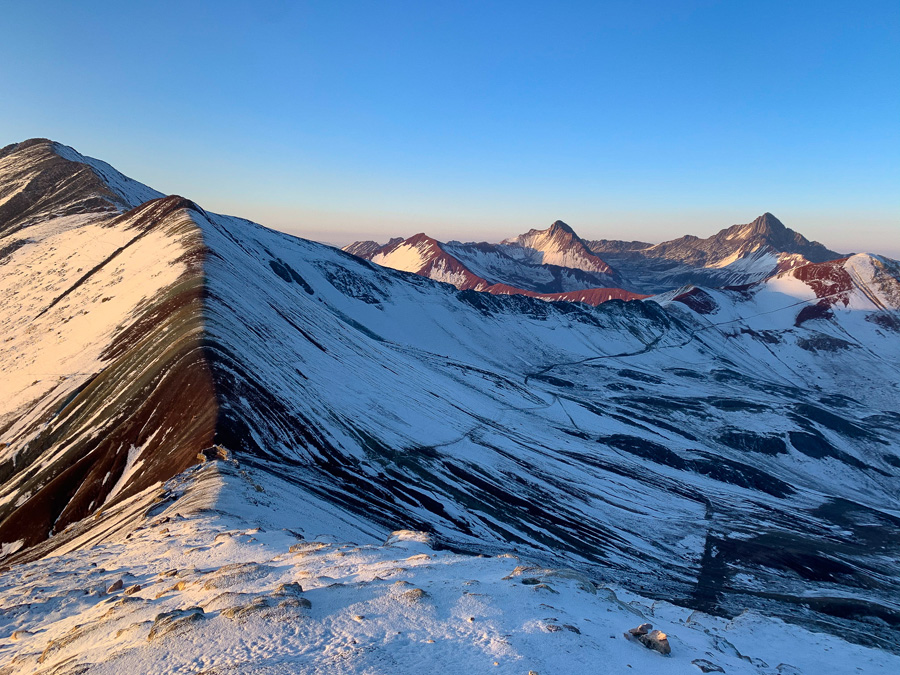
Appreciate the epic Abra Warmisaya Pass. This is truly an epic 360° panoramic. Rainbow Mountain in the far off distance and the alpine lakes and glacier peaks are behind you. The Warmisaya Pass towers at 16,355 feet!
When ready to depart, take the trail downhill to a dried up lake. Since it was on the border of the dry season, there was no water source there.
The trail is not too defined once you reach the bottom of the trail. We wandered off the path to reach the GPS section towards the campsite near the water source.
An offline map here is essential. There are a few “different trails” marked on Maps.me. The most obvious landmark between the pass and Rainbow Mountain is the covered shelter area.

⁉️ AUSANGATE TRAIL UPDATE 2023 | Since completing this trek, I had been notified that the shelters were torn down in 2022. Recently, I have been contacted that there are again a few shelters here and that they are the property of AB Expeditions. AB Expeditions uses these shelters for their guided tours. Please contact them here about all inquiries about the shelters. Remember, at this altitude, snow is more than likely overnight.
Be mindful that this area has no outhouse or running water. There is a water source here that is less than 5 minutes away, but the water is mucky and must be filtered and boiled. During the summer season, the water is even more scarce.
Also, the communities and the government continue to have discrepancies over the ownership of Rainbow Mountain. This section of the Ausangate trek will constantly change and the trails that lead to Rainbow Mountain will, too. It is rumored that the government wants to add Rainbow Mountain to the popular Cusco Tourist Ticket, but has not been able to obtain the rights. Time will tell.
Behind the shelter area marked on the Ausangate trek map is the trail that leads to Rainbow Mountain. This trail is a little more obvious than the previous section. Be careful that this trail section is unmarked and the walk takes 30-45 minutes to the viewpoint. This path is more of a “goat trail” that the horses and alpacas use than travelers.
As the trek evolves, the trails will too. If heading towards the campsite, it’s best to walk around the murky waters or meet up with the trail behind the lake.
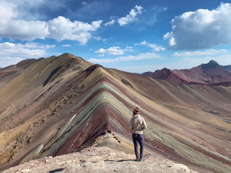
Exploring Rainbow Mountain


Honestly, Rainbow Mountain is worth the hype. Maybe it’s because we had the beautiful place basically all to ourselves. There were locals here celebrating a small festival simply enjoying the views in their traditional clothing.
Rainbow Mountain is also known by its Quechua name of Vinicunca, which means “colored mountain.” The highest lookout point stand of Rainbow Mountains is at 16,522 feet.
Rainbow Mountain Entrance Fee | Cost: 10 PEN ($2.75)
Don’t Skip Red Valley! (Valle Rojo)


Yeah, Rainbow Mountain is cool and all, but don’t overlook the nearby Red Valley. In fact, from the viewpoint of Rainbow Mountain, you can see Red Valley in the distance. Red Valley is a 45 minute hike away from Rainbow Mountain. The site is truly otherworldly.
Although so close, barely any tourists take the uphill climb to Red Valley. Most tour groups don’t stop at Red Valley.
Red Valley looks like you’ve stepped onto another planet, with the bright red soil and barren hills, it can almost appear Mars-like. There are a few different viewpoints, but all offer breathtaking views. Take in those 360° vistas and see Ausangate towering in the backdrop and the not-so-distant Rainbow Mountain.
Red Valley is a real treat, and in my opinion, more awesome than Rainbow Mountain.
Red Valley Entrance Fee | Cost: 10 PEN ($2.75)
Hiking Logistics | Day 3
- Total Distance: 9 miles (Includes Rainbow Mountain & Red Valley)
- Duration: 5 – 7 hours of hiking, but longer for exploring the sites
- Tips: Most tour groups will depart Cusco early in the morning, so after 14:00 there are less tourists. Come back in the morning to watch the sunrise glisten on Rainbow Mountain. Be prepared for the weather to change instantly.
- Garbage: No garbage drops at the campsite or from this path to Rainbow Mountain. Fee Bathrooms at Rainbow Mountain
- Sleeping Tidbits: The covered shelters are owned by AB Expeditions. We went to bed and woke up to quite a bit of snow, so be prepared for an extra cold night. There are no outhouses or running water, just the mucky lake water.
- Hikers who want to end their Ausangate Trek can opt to take transportation back from Rainbow Mountain to Cusco. There are plenty of options with so many tours and day trippers.
Day 4 | Campsite Near Rainbow Mountain to Machuraccay Lodge

Waking up early to watch the sunrise from Rainbow Mountain is a must. Leave the campsite before 5 a.m. and watch the mountains be bathed in an orange hue.
After the sunrise, follow the same route you took the day before. Go through the Warmisaya Pass, walk past the Anantapata Lodge, and head to the shelter near Laguna Ausangatecocha. The shelter is a great place to have lunch, stock up on water, and prepare for the uphill climb to Abra Palomani, the highest pass on this trek.


Begin on the path which follows past Laguna Ausangatecocha. The trail can disappear at sections, but follow the grassy path towards Abra Palomani Pass. Soon the trail becomes a little more visible and you’ll see the distant rocks that sit at the top of the pass.
Palomani Pass is the tallest pass of the Ausangate Trek at a jaw-dropping altitude of 17,060 feet! Whew! This climb doesn’t feel as steep, since the uphill climb is more gradual.

From the Palomani pass start downhill and look towards the left for the distinct “Red Lake.” There is a high-end lodge, Machuraccay Tambo hiding below the cliffside. Past the lodge, it’s possible to camp. There are no camping facilities, but plenty of fresh water. Set up camp a little ways away from the lodge, where the large boulders protect one side of the tent from the wind.
Explore Red Lake


This epic lake is worth some exploration. Besides the stunning mountain backdrop, the glacier dips right into the lake. There are usually large ice chunks floating on the surface. There really isn’t a direct path, but it’s quite straightforward to reach the shores of this peculiar lake. The path is of rocks, so don’t visit the lake in bad weather as the rocks can be slippery.
Hiking Logistics | Day 4


- Distance: 8.75 miles
- Duration: 6 – 8 hours
- Tips: Take a break at the shelter near Lake Ausangatecocha before climbing Abra Palomani. Make lunch and stock up on water. The trail after Laguna Ausangatecocha isn’t clear, but the uphill path to Abra Palomani is.
- Garbage: At the shelter near Laguna Ausangatecocha, none for campers sleeping near Machuraccay Lodge
- Sleeping Tidbits: Campers should set up near the large boulder rocks near the Machuraccay Lodge to help protect from the wind. The Machuraccay Lodge was locked and closed with the rooms not even set-up yet. No outhouses, but lots of fresh water coming from the stream. We cooked next to the lodge to help protect from the wind.
Day 5 | Machuraccay Lodge to Lakes Campsite


Leave early from the Machuraccay Lodge and follow the path towards the village of Pampacancha.
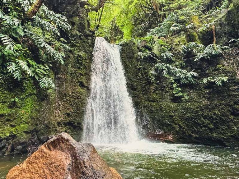
After Pampacancha, there is a waterfall a little off the main trail that makes for a great place to enjoy breakfast, refill waters, and prepare to take one of the last sections of the trek.
Another large waterfall on the river marks the start of the next trail section.


The main path follows along the river. It’s best to keep to the left side of the river. This path is incredibly scenic and is filled with llamas and alpacas. Continue on the path, a little further down will be another shelter.
This shelter has camping spaces and a water source. Sadly, the bathrooms were locked.
Continue along the trail. Keep an eye out for blue and white arrow markers, which are sporadically found along the rocks. These arrows will point in the right direction to the major pass of Abra Khampa. Walking this trail boasts some epic views of two large mountains with a large glacier between them.
Abra Khampa is 16,568 feet and is marked with tons of cairns, the signature piles of rocks made by humans. From Abra Khampa, the path continues to another smaller unnamed pass. After these ups and down, prepare for the path to start descending for the final campsites.
The Mirador & Campsite | Day 5


Follow the trail. Eventually, it will split, but we followed the blue sign to the left. We went to the left because we saw there were plenty of options for camping. The first campsite is rather forgettable, but continue on to an awesome lookout. Just downhill from the lookout are plenty of options to set up camp.
Wander and hike around the lakes for awesome views.
From here Pacchanta is only 4 miles.
Hiking Logistics | Day 5
- Distance: 10.5 miles
- Duration: 7 – 9 hours
- Tips: Check-in with the offline map as these trails aren’t as defined
- Garbage: At the viewpoint near the recommended campsite for Day 5
- Sleeping Tidbits: Between the Machuraccay Lodge and Pacchanta there are tons of sleeping options. There’s the lodge on the path after the village of Pampacancha and before the Abra Khampa Pass. There are multiple campsites to choose from by all the lakes, which are only a few miles before Pacchanta. Most of these campsites have outhouses and running water.
Day 6 | Lake Campsite to Pacchanta


Leave early so you can enjoy a soak in the hot springs at Pacchanta. Follow the lakes on the trail and continue into the community. There are a few smaller and scenic lakes along the way.
The trails near the lakes are really well marked and trotted on by day trippers from Pacchanta. The lakes are part of the 7 Lagoons de Ausangate guided day hike.
Follow the trail into Pacchanta, where the hot springs are waiting for you!
Entrance Fee | 5 PEN ($1.25) | Basic facilities like changing rooms
The tiny village of Pacchanta has a few restaurants that are serving up a daily menu for around 10 PEN. It’s pretty easy to ask around and catch a car for Tinki.
✈ Peru Travel Planning | 14 hot springs in Peru that are worth a dip
Those who wish to stay at one of the guesthouses can opt to take a day hike to the lakes skipped on the last day, Laguna Comercocha and Laguna Tika q’ocha. Typically, the Seven Lakes of Ausangate, or “Siete Lagunas Ausangate Cusco,” is done as a full-day trip from Cusco as a loop trail. Hence, on the last day of the Ausangate Trek, you will see more people and tour groups.
Hiking Logistics | Day 6
- Distance: 4 miles
- Duration: 2 hours
- Tips: If planning on using the hot springs, leave early to have plenty of time to relax and enjoy the public baths, since buses from Tinki to Cusco can be limited
- Garbage: At the viewpoint near the recommended campsite for Day 5
- Sleeping Tidbits: Pacchanta is small, but those mountain views from the hot springs may just entice you to sleep in the tiny village. There are a few sleeping options in the community.
☛ Psst… Love Pacchanta village? Here are more charming villages of the Andes Mountains to fuel some serious wanderlust.
How to Return to Cusco
To return to Cusco from Pacchanta, catch a car from Pacchanta to Tinki, just ask around. The taxi should be no more than 30 PEN ($8) for the entire vehicle.
Taxi from Pacchanta to Tinki Logistics | Cost: 30 PEN ($8.25) for the entire car | Duration: 30 minutes | Taxis drop-off at the main plaza in Tinki
From Tinki, buses run back to Cusco throughout the day. The buses depart from the main plaza across from the market in Tinki. The buses may be delayed or canceled if there are not enough people on the bus.
Remember, you may have to transfer buses in the village of Ocongate. It is important to GET A TICKET from the bus driver, so you do not get charged twice! The buses from Tinki to Cusco are much less frequent than the buses from Cusco to Tinki.
🚌 Tinki to Cusco Bus Logistics | Cost: 15 PEN ($4) | Duration: 3 hours | Bus schedule: Sporadic and varies, check with locals & drivers | We had to wait in town for over an hour for a bus to depart | Our bus was @ 14:30
Returning to Cusco?
Looking for more things to do in Cusco?
Why not visit these free Inca ruins in Cusco, or climb one of the tallest mountains in Cusco, Cerro Picol? Did you visit the 16 sites of the Cusco Tourist Ticket or eat at one of these incredible Cusco restaurants?
Of course, there are plenty of incredible places to visit in the Sacred Valley. I love to base in the village of Urubamba and explore everything from Ollantaytambo all the way to Pisac.


Total Cost of Ausangate Trek Without a Guide
So how much does it cost to complete the Ausangate trek without a guide?
The more people you trek with, the more the expenses can be cut down, but that also goes for the tour costs. The more hikers, the cheaper the Ausangate Trek.
I hiked the Ausangate Trek without a guide with three people, so our main costs were divided by 3.
Prices on the table are rounded to the nearest 25¢
| AUSANGATE TREK EXPENSES | PEN (S/) | USD ($) |
| Propane Tanks (2 Large for 3 people S/80) | S/ 27 (price per person) | $7.50 |
| Food & Snacks for 6 days (price per person) | S/ 40 | $ 11 |
| Bus Fare: Cusco – Tinki (Round-Trip) | S/ 30 | $ 8.25 |
| Lunch Menu in Tinki | S/ 5 | $1.50 |
| Taxi Fee Tinki – Upis (price per person) | S/ 10 | $2.75 |
| Ausangate Entrance Fee | S/ 10 | $2.75 |
| Upis Hot Springs | S/ 5 | $1.50 |
| Rainbow Mountain Entrance Fee | S/ 10 | $2.75 |
| Red Valley Entrance Fee | S/ 10 | $2.75 |
| Pacchanta Hot Springs | S/ 5 | $1.50 |
| Lunch Menu in Pacchanta | S/ 10 | $2.75 |
| Taxi Fare to Tinki (price per person) | S/ 10 | $2.75 |
| TOTAL | S/ 172 | $47.75 |
The Ausangate trek without a guide cost me around $50 USD for the 6 days
Of course, this cost can vary due to factors like whether or not the locals decide to charge for camping and land passage or not. It also depends on if they are collecting entrance fees for the main attractions and the park itself. Make sure to carry plenty of small bills (Soles).
The highest expenses for the Ausangate trek were food for six days and public transportation costs. Make sure to carry enough food for 6 days, but not too much to weigh you down. The pack can feel extra heavy at these altitudes.
Expenses can be lowered by skipping menus in the villages, the hot springs, and the highlighted sites of Rainbow Mountain and Red Valley (but I don’t recommend that)!
Many of these tiny villages rely on tourism, so try to purchase a meal when you can, or a bracelet from locals selling. This money is essential for these communities to survive.
Final Thoughts | Ausangate Trek Without a Guide

In conclusion, the Ausangate trek without a guide is a tough challenge, but the rewards are absolutely remarkable and worth the effort. Of course, always be honest with yourself about your navigation, physical abilities, and altitude. The Ausangate trek should not be done without thought, research, and a pause.
Take the road less traveled and walk high in the mountains next to hundreds of llamas and alpacas. Savor in those (literally) breathtaking views of mountains covered in glacial peaks that feed stunning, turquoise alpine lakes. The diverse landscapes of this region will leave tears in your eyes from the beauty and your heart so full it will feel as if it would burst.
From Cusco, it’s possible to reach the Ausangate trailhead via public transportation. Make sure to be totally prepared for this epic multi-day trek, which never dips below 14,000 feet. This 6-day Ausangate trek route follows a common circuit with an out-and-back hike to the popular Rainbow Mountain and Red Valley.
This guide includes a detailed schedule on how to hike the Ausangate trek without a guide and the general cost of this expedition.
The Ausangate trek without a guide was one of my favorite moments throughout my entire stay in Peru. The diverse landscapes and mountains recharged my soul and made me fall deeper in love with this amazing country.
Have you heard of the Ausangate trek? Did you hike the Ausangate trek without a guide or did you use a guiding service? I would love to hear your opinion of the Ausangate trek?! Are there any trail updates for those hiking the Ausangate trek without a guide? Let me know in the comments below!


Disclaimer: There’s a chance this post contains affiliate links, and I receive a small (but grateful) portion of the sale. There’s no extra cost to you, and I only promote things that I use and love.


I had no idea about this trek but it looks incredible! Definitely adding it to my list for when I visit Peru.
Thanks Krista! Enjoy this awesome trek! 🤗
Wow this looks like an incredible experience! I always prefer to do hikes without guides although sometimes thbere is simply no other way. I admit I have only heard about the Rainbow mountain, but not the other places included in this hike – you put together such a great detailed post with all the information needed! Thanks for sharing it, I´m saving it for our next South American adventures 🙂
Thanks Katja! I also enjoy hiking without a guide, since it really lets me connect with the mountains at my own pace. I hope you get to Apu Ausangate on your next South America trip! 🏔
This trek looks so cool! I would love to see the Rainbow Mountain and the red Valley and all those turquoise lakes! So amazing! Thanks for all the tips 🙂
It was definitely a highlight of my time in Cusco! Enjoy xx
Wow what an incredible hike! This looks so challenging but those views, lakes and hot springs look worth it! As much as I’d love to do this one day I’d be hesitant as I get altitude sickness pretty bad over 7,000 ft. It can take me 5 days to acclimate. So many great tips like taking extra coca leaves to give locals.
Thanks Vanessa! Yes, acclimation is so important in Peru, especially near the Cusco region. There are some great day trip options from the small villages at the start and end of the circuit, too! 🌱
Wow – this looks like an amazing adventure! Thanks for the heads up about the dogs, too. It was a similar situation in Panama when we were going on (much shorter) hikes in the mountains. I got a bit freaked out (worst thing to do, I know). But it would be all worth it again for the alpacas!
Thanks Marguerite! Yes, the dogs can be a little worrisome, but generally we found them manageable. I know the alpacas are so incredible and they look right at home here in the mountains.🦙
Wow, this is epic! It’s a dream of mine to go on an independent multi-day hike like this. i wouldn’t call myself an experienced hiker though, so I might have to practice on a few shorter hikes before attempting anything of this scale. Still, this is a useful guide that I will save for future reference.
Thanks Ummi! I tackled quite a few day hikes in Peru before this one. I think proper acclimation is key! Thanks for saving my guide. 🙏
This looks like a great adventure, the views are to die for. Not sure I could handle a 6-day hike, I am a bit of a wimp.
Thanks Larch, the Ausangate trek is a challenge, but the views are so worth it! There are some day hike options from the two villages that start and end the trek. 🥾
What an ;amazing trek. Something i would have loved to do in my younger days. These days I read and visit through posts like this. What a stunning place. Thank you x
Thanks so much Bree! Glad I could bring this magical place to you. 😊
Wow Megs, this is amazing. I can tell you had an absolutely incredible time on this trek. The closest I’ve done to this is the Inca rail way back in 1978 before it was a thing – started on a flying fox over a river canyon and followed a hand-drawn map. Definitely a highlight of my travels, as I bet this is of yours. Fabulous photos, and excellent details for others to follow.
Thanks Alison! It sounds like you had a true expedition yourself, a hand-drawn map? How incredible! I love adventures like that.Thanks for sharing your experience. xx 🤗
Thanks a lot these valueable information. One day I will trek this route 🙂
Thanks! I hope you can, it’s a spectacular part of Peru 🎒
Hey Megs
I’m gonna do this trek in one and a half week and i have no idea about what and how much food to take with me on this adventure without having a backpack that weighs way too much! Any recomandation?
Thx a lot for all the valuable information!
Hey! Thanks for reading. The food is one of the biggest challenges since there are no places to replenish supplies along the route.
What we did was precooked some food and brought it. For example, we precooked potatoes and then added them to soup packets at night. We also made a protein stuffed quinoa salad and sweet potato and black bean burritos that were individually wrapped. For breakfast, oatmeal packets were light yet hardy. The San Pedro Market in Cusco has tons of nuts and dried fruits. We also carried things like noodle packets, pasta, sauce packets, and tins of tuna. There were a few garbage drops along the way which help take the weight off. We brought back food, so we over-packed. Enjoy the hike! 🎒🥾
Hi Megs, I am planning my birthday here. My husband and I are into multi-day backpacking trips since the pandemic. We just did Picos de Europa( ruta refugios) and tour du mont blanc, all self guided. Now planning Ausangate in October, and Torres del Paine in March.
I am glad I found your post! Lots of valuable info to self guide this trip. Certainly keeping all your tips at hand for this one. I have few questions: this trek is rated difficult, are any of the high passes exposed as in not suitable for those in fear of heights? Any difficulties other than strenuous/fitness level and altitude acclimatization? Feedback much appreciated 🙂
Hey Ivette! So glad this comes in handy! I so have the Picos circuit on my wishlist.. that’s so awesome you have completed it! And what an epic way to spend your birthday!! Cusco region has so many incredible hikes and adventures. (I spent my birthday in 2020 at Waqrapukara which is also in the South Valley)
As for your questions:
This trek I would consider difficult as for its remoteness and high-altitude. There are no really scrambly parts of the trail or close confined spaces. No mountain chains, or ladders. The trek is vast and the mountain passes are quite open. There weren’t any sections that were narrow like the Colca Canyon. I hope that helps with the fear of heights.
Besides altitude, the hardest part is carrying the weight of the backpack. There are no tiendas, so you will have to carry all supplies, fuel, ect for how many days. Remember there are many routes and add-ons, so it could be 4-6 days. It sounds like you have done some multi-day treks so you probably have a general idea of how much you eat and snack along the way. There are places to eat in Tinki and Pacchanta so keep that in mind when packing food. The Cusco markets are incredible and you can really utilize the beautiful markets with things like bring precooked potatoes, quinoa, and so on. In the end, we carried too much food! So it was an extra weight we didn’t need at that altitude. Finally, swap your coffee for coca leaves. I will never drink coffee above 4500 m again 😊
Hope this helps! You will really enjoy this trek! 🥾
Great post. But most people will not have a tent, sleeping bag, sleeping mat, portable stove, other camping equipment etc to be able to independently trek this unfortunately.
Thanks Ben-
Yes, the gear is vital for this trek since it is so remote. That’s really what makes this trek so incredible. The good news is there are tours that run from Cusco that provide gear and many places in Cusco that do rent gear. There are even possibilities to do day hikes from both sides of the circuit. 🥾
There are some ways around the gear. Besides renting, there is a huge barratio in Cusco that sells anything and everything. Most oftentimes it is used, so it comes at a discount. I really utilized the Cusco Hike Club to find people to hike with since I had all the gear, but sometimes no one to trek with. The group is gold and sometimes people are flash selling gear or will even borrow some items out. It’s really a great community. 🙂
I have been fortunate to take some incredible trips to South America, both with and without my gear. I remember the first time packing all the stuff in my backpack thinking how much room it took and how heavy it was. In the end, the rewards far outweighed the cons including seriously cutting down on my travel expenses and allowing me to get off the beaten path. Ultimately, it truly changed how I traveled. 🎒
All the best on your future travels
Terrific description of your experiences there! I’ll be following in your footsteps at the end of June; I’ve done this type of thing many times, and do it without a second thought, but my 8-year-old son will be with me on this one so I’m planning more than usual. After reading your post and taking notes, I feel like I’ve already been there and feel extremely well prepared for what to anticipate at every turn. Thanks!
Thanks so much, Jason! Wow… what an experience for you and your son! You will have an incredible adventure together, enjoy!
First off, I want to express my intense gratitude for your incredibly detailed description and guide. It helped so, so much with planning. I am indebted to you! I relied on this description, you are the bomb for writing this up.
That being said, I have 2 updates and a disclaimer.
Water is PRECIOUS. Every guide or itinerary we read claims water is plentiful and not an issue. We didn’t find this to be the case. A lot of alpaca shit water unfortunately. We struggled a bit, expecting running/clear water. We had iodine drops so we were ok but all water sources had really gross floaties. We found extremely clear glacier water at the huge lodge before Arba Warmisaya pass. A very nice Quechua man helped us out for free. (We tipped him, but expect to be charged 100 Sol total along the way by locals. They’re all super nice but occasionally charge 10 Sol pp to walk on their land). The glacier water was crystal clear and saved us.
On day 1, if you have the ability to push past the mirador camp site from upis, definitely do. It was the best decision we made. We had to cross a small stream barefoot due to some trail inconsistencies. About 2 miles up the trail there is a camp site for 15 Sol pp. A-Frames/domes on a farm owned by some Quechua locals. An endearing and awesome experience. Camp here. -13.815529,-71.271687
In between Abra Warmisaya pass and rainbow mountain is an outdated trail. The trail you have on the KMZ is unfortunately nonexistent anymore, and the A-Frames you stayed in about a mile from rainbow mountain do not exist anymore. They’ve all been torn down, we saw the remnants. We didn’t realize this and were caught in a pickle as the sun went down. Do wild camping elsewhere.
Just a heads up for anyone else who follows this guide! Every other piece of information is spot on.
Thank you SO much for your detail and description. I hope my comments are informative! Definitely do this trek. We only did upis to rainbow mountain. The alititude got to me.
Thank you so much Taylor for reaching out! I am so glad that this Ausangate trek guide came in handy! 🎒
Things always change so fast in Peru, so I truly appreciate the hiking updates. It is such a bummer that the A-frames near the backside of Rainbow Mountain have been torn down. Sadly, the government and the communities have had and probably will continue to have disputes over the land, so I can see the hike constantly changing until there is an agreement.
Thank you for adding the piece about water. I hiked on the cusp of rainy season, so I appreciate information from a hiker during the start of dry season. We precooked a lot of food so to not use too much water for meals. I will go back and mention that in my article.💦
Yes, the altitude is a beast… I had been in the Cusco region for over a year and the altitude got me on Day 2. I will never drink coffee at that altitude again 🙂
Looking forward to your updates 🥾