Choquequirao to Machu Picchu Trek in 9 Days | A Real Expedition & Rewarding Journey
The Choquequirao to Machu Picchu trek is the ultimate adventure for those looking to experience an “off-the-beaten-path expedition” to the once-lost Inca Citadel. This 9-day trek is intense and is for those who crave an intrepid quest. Be rewarded with a tough, yet incredible journey through the Andes Mountains to the Modern World Wonder of Machu Picchu.
Explore untouched Inca sites like Choquequirao and trek over multiple mountain passes. There are countless epic viewpoints, small mountain communities, and reflective moments walking in total solitude.
This trek begins in the quaint village of Cachora and ends at Aguas Calientes or Machupicchu Pueblo, the base to explore Machu Picchu. This extreme trek is all about the journey and has enjoyable points of interest along the way. The final reward is to stand at the awe-inspiring “lost city of the Incas,” knowing you walked nearly 80 grueling miles to see it.
This Choquequirao to Machu Picchu trek guide includes a day-by-day itinerary, how to reach the trailhead in Cachora, what to pack, useful tips, and more.
Here’s a trekking guide to Machu Picchu from the Choquequirao ruins.
Table of Contents
Disclosure: This is part of my Hikes & Adventures series, which means these treks can be strenuous and challenging. These are my experiences and I am not an expert. Please have all the proper equipment, verify the weather conditions, use professional resources, do your own research, be mindful of constantly changing trail conditions, and take into consideration your own physical abilities and/or limitations. These guides are for entertainment purposes only. Please see my full disclosure for more information here.
- Choquequirao to Machu Picchu Trek Map
- Daily Schedule & Mileage of Choquequirao to Machu Picchu Trek
- Important Info Before Departure
- Choquequirao to Machu Picchu Trek Tips
- Choquequirao to Machu Picchu Trek Packing Guide
- Cachora Village the Trailhead to Choquequirao
- Part I: The Choquequirao Trek
- Explore the Choquequirao Archaeological Park
- Part II: Choquequirao to Salkantay Trek
- Part III: Joining the Salkantay Trek to Machu Picchu
- Arrival in Aguas Calientes (Machupicchu Pueblo)
- Exploring Machu Picchu
- How to Return to Cusco from Aguas Calientes
- Total Cost of Choquequirao to Machu Picchu Trek
- Choquequirao to Machu Picchu Trek: A Real Expedition
Choquequirao to Machu Picchu Trek Map
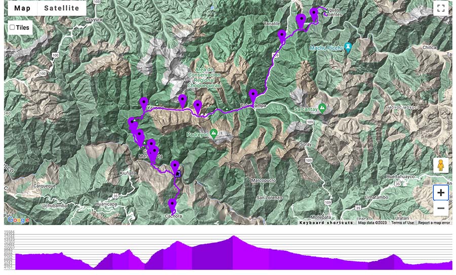
There is only one path, so it’s hard to go off-track unless you wander OFF the trail. Stay on the apparent trails!
Choquequirao to Machu Picchu Trek Overview & Stats
- Point to Point Trail
- The trailhead begins from the village of Cachora and finishes in the small Pueblo of Aguas Calientes, the gateway to Machu Picchu.
- Miles: +/- 78 miles (125.5 KM)
- Trekking Days: +/- 8 Days with day 9 utilized for exploring Machu Picchu
- Total Days: This itinerary is a total of 10 days, which includes an overnight in Cachora before departing.
- Difficulty: Extremely Difficult due to altitude, remoteness, and not seeing people for days
- Never hike alone in the Andes Mountains and be properly acclimated
- Altitude: The section from Cachora to Choquequirao includes a steep descent followed by a steep ascent. Choquequirao ruins are found at an elevation of 10,017 ft (3050 m). The Choquequirao pass to begin the intrepid trek section is 10,735 ft (3272 m) The next two days include two more high altitude passes, the San Juan pass 13,615 ft (4150 m) and Abra Mariano Llamoja 15,289 ft (4660 m).
- Choquequirao to Machu Picchu Trail Markers: The Choquequirao trek is well-marked with blue and white signboards. After Choquequirao, there are random and fewer blue and white signboards. Once the trail merges with the Salkantay trail the path has more distinct signboards
- Signboards are in Kilometers
About This Choquequirao to Machu Picchu Trek Itinerary in 10 Days
It’s best to think of the Choquequirao to Machu Picchu Trek in 3 sections.
- Choquequirao Trek
- Choquequirao Ruins to Salkantay Trek
- Last Half of the Salkantay Trek to Machu Picchu
This itinerary is 10 days, with a night in Cachora before departure, 8 days of trekking, and one full day to explore the Machu Picchu citadel.
This aggressive itinerary passes through untouched ruins, authentic hamlets, and stunning mountain passes. It merges with the popular Salkantay Trail and twists through the lovely coffee region. Finally, it ends at the gateway to Machu Picchu, the tourist town of Aguas Calientes.
It’s best to take acclimation seriously, be in good physical shape, feel comfortable walking on quiet mountain trails, and always hike with a buddy. These mountains have a mind of their own and the weather can change fast. Some parts of the trail rarely see hikers.

This itinerary has been thoroughly updated by feedback from a recent hiker who was kind enough to provide me with information on current trail conditions. The major issue is there is no more wild campsite (Day 3) due to a large rockslide. Hikers will need to camp at the terrace Inca ruins of Pinchaunuyoc or push across the river to Maizal. In Maizal sleep at one of the two campsites (Camping Familia Perzer or Camping Señor Valentin).
Daily Schedule & Mileage of Choquequirao to Machu Picchu Trek
These distances are based on my actual movements including exploring, grabbing water, and taking photos, so they may not align perfectly with the mileage of the map.
Remember Day 3 & 4 will look different as there is no more Wild Campsite due to a rockslide.
My Personal Choquequirao to Machu Picchu Trek Route
| Day | Start Point | End Point | Miles |
| Day 1 | Cachora | Santa Rosa Baja | 17.25 |
| Day 2 | Santa Rosa Baja | Choquequirao Archaeological Park | 5.25 |
| Day 3 | Choquequirao | River Campsite*** | 6 |
| Day 4 | River Campsite*** | Yanama | 7.5 |
| Day 5 | Yanama | Totora | 12.25 |
| Day 6 | Totora | Sahuayaco | 14 |
| Day 7 | Sahuayaco | Llactapata Lodge | 7 |
| Day 8 | Llactapata Lodge | Wayna Picchu Camping (Before Aguas Calientes) | 8.75 |
| Total Trek Mileage | 78 | ||
| Day 9 | Machu Picchu Exploration | & Climb Machu Picchu Mountain |
Suggested Alternative Choquequirao to Machu Picchu Trek
With the wild campsite non-existent, I would now suggest this alternative Choquequirao to Machu Picchu Trek Itinerary.
- Day 1 | Choquequirao Trailhead (Capuliyoc) to Marampata
- Day 2 | Marampata to Choquequirao (Explore park all day)
- Day 3 | Choquequirao Ruins to Maizal (after River Crossing)
- Day 4 | Maizal to Yanama
- Day 5 | Yanama to Totora
- Day 6 | Totora to Sahuayaco
- Day 7 | Sahuayaco to Llactapata Lodge
- Day 8 | Llactapata Lodge to Aguas Calientes
Important Info Before Departure of Choquequirao to Machu Picchu Trek
If planning on hiking the whole Choquequirao to Machu Picchu trek, you must purchase your Machu Picchu entrance tickets before departure. Online ticket sales are the only way to guarantee entrance into Machu Picchu.
The trek will take those in above moderate to excellent physical shape for around 9 days. If nervous about weather or physical limitations, it may be best to add in a “cushion” day or two.
The Choquequirao Archaeological Park is massive and there’s a lot of ground to cover. For those who want to thoroughly discover Choquequirao, spend an extra day in the park.
More on Machu Picchu Tickets
Machu Picchu is one of the Modern Wonders of the World and a UNESCO World Heritage Site. Overtourism is a major problem and it has been regulated by new circuits. Visiting Machu Picchu requires a circuit. If climbing an additional mountain on Machu Picchu it includes a circuit.

- Machupicchu Mountain includes Circuit 3
- Waynapicchu or Huchuypicchu Mountains includes Circuit 4
- “Llaqta de Machupicchu” is the standard ticket for Machu Picchu that allows passage of Circuits 1 – 4.
- Circuit 2 is the most complete tour of Machu Picchu
- More on the Machu Picchu Circuits here
Reserve Machu Picchu tickets online. For those ambitious explorers, make sure to add on one of the mountains: Huayna Picchu (usually booked out 2-3 months in advance) or Machupicchu Mountain. There is also Huchuy Picchu mountain, too. These viewpoints allow you to appreciate the sacred site of Machu Picchu from another angle.
Pick a date, and the number of people, and put in a request.
Have everyone in your group’s full name, date of birth, and passport information!
In-Person Tickets to Machu Picchu
There are no more ticket sales for Machu Picchu in Aguas Calientes. Tickets for Machu Picchu must be purchased and reserved online. In Cusco, there are two places to collect tickets: Casa Garcilaso and Calle Maruri #340
Choquequirao to Machu Picchu Trek Tips

The best time to hike from Choquequirao to Machu Picchu is during the dry season. For the region of Cusco, it’s between the months of May to October. It’s possible to hike in the shoulder months but be prepared for rainy conditions, rock slides, and unexpected detours to avoid sections of the trail that have been washed out.
The rainy season in Peru can be brutal, leaving many of the trails destroyed by mudslides. A few years ago was exceptionally rough, leaving many villages along the Salkantay Trail in complete despair. The wild camping site no longer exists due to large boulders occupying the once-flat area by the river.
Always keep an eye on the weather and stay up to date with trail conditions, especially if planning to hike this intrepid trail independently.
It is not common for the Choquequirao trek to shut down during the rainy season due to unsafe hiking conditions (rockslides). Always check the official government website for current trail closures and updates. During the rainy season, it is also common for the river between Choquequirao to Yanama to be so high that it is impassible.
Reach out to tour companies and the tourist information center in Cusco to verify that trails are up and running.
Sleeping Tips
If opting to spend the night in a guest house or campground, make sure to negotiate! Everything is negotiable from the plot, bed, room, WiFi, hot water, etc. Always be fair when negotiating as this is their land and wellbeing. Make sure to have a clear understanding of the agreed-upon price.
For example, we had a situation where we thought all parties had agreed upon hot water for showers in a guest house. Unfortunately, I guess we negotiated incorrectly and it turned into quite the situation where my hiking buddy had to negotiate the price naked from a cold shower.
The host and I could not stop laughing and today is a fun story and an even better learning experience!
Everything is negotiable!
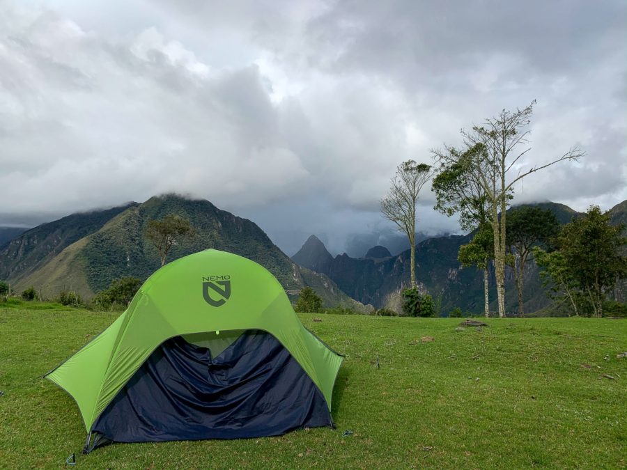
Do I Need a Tent for the Choquequirao to Machu Picchu Trek?

While there are simple guesthouses found from Cachora to Choquequirao, they can be hit and miss after the Choquequirao ruins. I still think it is essential to carry a tent on the Choquequirao to Machu Picchu trek. As this trek is remote and things can change, I would personally not rely on any guesthouse being open.
One of the highlights for me was camping at the Choquequirao campground. The camping is included with the price of the Choquequirao entrance ticket of 60 PEN.
Camping provides flexibility and insurance for safety. Camping is also cheaper than renting a room.
Always Hike with a Buddy
Like most of the multi-day treks near Cusco, it’s important to never hike alone. Make sure to always hike with a buddy and if you can’t find one, the Hike Club Cusco Facebook is a great place to start searching for one.
I hiked the Choquequirao to Machu Picchu trek with a new friend I met in Ecuador. Some sections of these trails have little to zilch foot traffic, so at least try to hike with one other person. There were two days when we didn’t see a single soul, not even a local person except in the villages.

It’s important to be properly acclimated for the Choquequirao trek. Spend at least a few days in Cusco to see how your body reacts. Carrying coca leaves and sipping on coca tea is a great way to help alleviate the symptoms. Altitude sickness can be deadly, so never underestimate the power of the mountains and listen to your body.
Always stay on the trail and leave no trace. There is only one pathway, so it’s hard to get lost unless you leave the trail. Always take into consideration your physical abilities and limitations.
The Choquequirao to Machu Picchu trek is tough and intrepid so if hiking it independently, never hike alone. If feeling unsure about this challenging route opt to use a local guide or join an organized tour.
Choquequirao Trek to Machu Picchu Tours
While this guide focuses on hiking Choquequirao to Machu Picchu without a guide, there are a few limited tour options. Many hikers depart from Cusco using organized tours.
If worried or questioning the many risk factors of the Choquequirao to Machu Picchu trek, such as the altitude, intensity of the route, carrying the proper gear, or your physical capabilities, always opt for a guided tour.
The tours from Cusco can be pricy depending on how many people are in the group. Many of the treks have modified itineraries and are not the complete Choquequirao to Machu Picchu trek.
➜ 8-Day Choquequirao Trek to Machu Picchu
➜ Choquequirao to Machu Picchu in 7 Days
Choquequirao Wasi is a guesthouse found near the Capuliyoc trailhead to Choquequirao. Run by a local guide, they also provide trekking information and support and is a great place to sleep before departing on this multiday trek.
There may be possibilities to find a local guide in Cachora or Marampata on the Choquequirao trek.
Personal Feedback on Multi-day Choquequirao to Machu Picchu Trek

We hiked the first part of December, and we lucked out with the weather. It usually dumped down rain every single night, starting around 6:00 p.m. We would try to be at our “destination” by 16:00 to set up before darkness and the rain would set in. The days were hot and sunny, but the rain came every night.
We used a mixture of campsites, wild camping, and guest houses.
We didn’t fight the malicious black flies, but they can be a major issue, especially at the lower elevations. They are less of an issue at high altitudes.
Packing Guide for Choquequirao to Machu Picchu Trek
These were the essential items I carried in my bag for the Choquequirao to Machu Picchu trek, but use what works best for you! We were two people, so it was nice to distribute out the weight of food and fuel.
Below find all my suggestions for camping essentials, gear, and food.
In my humble opinion, a lightweight tent is essential for the Choquequirao to Machu Picchu trek. I carried and loved my lightweight Nemo tent and the footprint.

Durable high-ankle hiking boots are necessary for the steep ascent and descent of the hiking trail. Salomons are excellent. As I hiked at the start of the rainy season, GORE-TEX is the best. Merino wool socks are game-changing when it comes to hiking.
Trekking Poles are also highly recommended for the extreme ascents and descents.
I love Osprey backpacks and found for a long multi-day trek that my Osprey Aura AG 65 Pack was perfect. Don’t forget a rain cover for your backpack, especially during the shoulder season and the rainy season.
I camped and slept in guesthouses, so I carried a lighter Sleeping Bag (a 50° Sleeping Bag), and a sleeping pad. A light liner or sleeping bag may also come in handy at the guesthouses. It’s not essential to carry a heavy alpine sleeping bag as the climate is a mixture of jungle and mountains.
One new gear item I’m totally pumped about is my Sea to Summit Spark Ultralite Spark Sleeping Bag (40°) that can double as an independent sleeping bag in warmer climates and a warm liner for future high-altitude hikes (like the Ausangate trek).
Water can be scarce along the way and I used my Water Filter Kit quite a bit. Water bottles are costly and create more unnecessary plastic waste. There were water sources along the way and at Choquequirao, but I always used the water filter. There is lots of farmland so bring water purification tablets if worried.
To save on plastic use, I carry a lightweight Hydra Flask water bottle.
If you want to save money, a Cooking Stove with enough fuel and supplies for at least 2 days is essential. There are meal options and snacks in Marampata and is a good place to stock up until Yanama or Totora. Once on the Salkantay trek food is easy to find. Make sure to have cooking gear and cutlery. I usually always bring a Swiss Army Knife.
I love an environment-friendly Multi-purpose Soap like Dr. Bronner’s in a small reusable travel-size bottle for dishes, body, and toothpaste.
Portable Battery Packs are essential for devices. Many places have solar panels and charge money to use them. Be mindful that on a cloudy day, you may be out of luck. I always download an offline map and use my phone for pictures.
Carry a Headlamp and a well-stocked First-Aid Kit with at least one Emergency Blanket per person and some coca leaves for altitude sickness. Bug spray is a must for the jungle-like climate. Sunscreen and sun protection go a long way.
A quick dry packable towel is a must if you want to shower.
Choquequirao to Machu Picchu Trek Clothing
It’s important to pack lightweight clothing that is made from quick-dry materials. Most of the weight in your pack should be reserved for food and gear.
For clothing, it’s alright to pack light as the afternoon heat will dry out clothes. I brought a lightweight clothesline to help dry clothes when the sun peaked out.
Try to avoid hiking in the afternoon heat, as the sun can be quite brutal and there is not much shade coverage along the trail. At night the temps can drop, so bring something warm.
A lightweight rain jacket comes in handy.
I like a long-sleeve Merino Wool shirt to protect me from the sun and bugs. I don’t usually hike in. a short-sleeved T-shirt. Additionally, hiking pants are a must. A buff also provides sun protection and helps to deter bugs.
Bring warm clothes for the night and it’s important to keep them dry! I used a warm fleece at night and picked up a hat and mittens along the way for high altitudes.
🥾 My Complete Peru Packing List for Multi-Day Treks
Misc. Essentials
- Phone with Maps.me offline downloaded! (Or any offline map)
- Lighters & Matches
- Toilet Paper, Wet-Ones, & Hand-Soap
- A few misc extra plastic bags in various sizes
- Chargers and Cords for Electronic Devices
- A shammy. It works great to wipe off a wet tent or doubles as a towel
- Passport to Enter Machu Picchu
- Tickets for Machu Picchu
- Cash (I don’t like to carry over $100 USD)
➯ Hey… don’t forget your Travel Insurance! I love SafetyWing
Food Suggestions

Peru has a wide range of food items that provide adequate fuel for mountain trekking. Pasta, quinoa, and potatoes are substantial. I love soup packets and canned tuna, which can be found at tiendas in more populated areas along the trek.
Precooking some of these items saves on fuel.
There are little food stands and campsites to replenish supplies along the way. It’s important to NOT rely on them! Sometimes, especially in the section from Choquequirao to Machu Picchu, many of these shops and campsites were closed and empty! I suggest carrying 2 days of food and snacks as a precautionary.
Along the way, Marampata, Yanama, and Totora all have excellent tienda options and tiny in-home restaurants. When the Choquequirao trail meets up with the Salkantay Trek, there are many options to replenish supplies and restaurants.
Cachora Village The Gateway to the Choquequirao Trailhead

The small village of Cachora is the gateway to the Choquequirao trek, which eventually leads to Machu Picchu. The Imperial City of Cusco has plenty of ways to reach Cachora.
Cachora can be reached via public transportation from Cusco. Additionally, there are private drivers.
How to Get to Cachora via Bus and Collectivos
There are buses and collectivos that can get you near Cachora.
Cusco to Cachora Bus
The public bus departs Cusco from the main terminal and drops at Ramal de Cachora. Ramal de Cachora is the main road above Cachora village and is about 9 miles from Cachora. You’ll need to walk or taxi in from Ramal de Cachora to the village.
🚌 Cusco to Ramal de Cachora | Departure: Terminal Terrestre Cusco | Bus companies: Brede, Sanchez, Palomino | Departure Times: 6:00 & 13:00, but verify at Bus Terminal | Average Fare: 25 PEN ($6.75 USD) | Duration: 4 hours
Collectivos to Cachora
There are shared cars that are smaller than the typical shared vans. These cars depart from Autos Abancay and will need to be filled before they depart. As the car is smaller, it’s typically faster than the buses and departs throughout the day.
🚌 Cusco to Ramal de Cachora | Departure: Autos Abancay | Departure when full | Average Fare: 50 PEN ($13.50 USD) | Duration: 3.5 hours
Private Drivers from Cusco to Cachora
Private drivers come with a hefty fare. This option may be better for those in large groups to help split the cost. A private driver is great for those not looking to deal with the hassle of public transportation. If using public transportation, try to negotiate the fare to the trailhead.
Usually, 5 people can fit comfortably in a tax, sometimes more.
🚗 One-way cost of a private driver | 300 PEN ($80 USD)
Cachora Village

The actual trailhead to Choquequirao is almost a 6.5-mile walk (2.5 hours) or a 20-minute drive out of town. For this reason, it’s best to sleep in Cachora village or head directly to the trailhead.
🚗Taxis from Cachora to the Choquequirao trailhead average around 40 PEN and are worth it
There are a few guesthouses in Cachora and is a nice area to prepare for the trek.
Alternatively, only a few steps away from the Choquequirao trek trailhead is the accommodation of Choquequirao Wasi. This locally run guesthouse rents out cabins and also doubles as a tour company. This guesthouse also sells food onsite and is located next to a small tienda. Wi-Fi and hot showers are available for a small fee.
Choquequirao to Machu Picchu Trek Part 1 | Choquequirao Trek


The first leg of the Choquequirao to Machu Picchu trek is Cachora to the Choquequirao trailhead to Choquequirao Archaeological Park. The official signage in Cachora shows the total distance to the Choquequirao ruins is 29 Kilometers (18 miles). All of the signposts along the way are marked in kilometers.
Remember, you won’t need to walk back to Cachora, so this is the first 2 days of the Choquequirao to Machu Picchu trek.
This is my detailed Choquequirao trekking guide.
The first decision of the Choquequirao to Machu Picchu trek is whether to walk or taxi to the trailhead. Looking back, I would have taken the quick taxi ride and saved my energy to hike all the way to Marampata on the first day.
At the trailhead make sure to purchase a ticket to the Choquequirao Archaeological Park and sign in.
Choquequirao Entrancee Fee: 60 PEN ($16.25 USD) | Ticket Office Hours: 8:00 -16:00
There are a few little tiendas here offering last-minute snacks, drinks, and a bathroom break! There are horses and guides to hire here. Use your best and personal judgment when making this decision. We chose to carry our gear and hike independently.
Day 1 | Cachora to Santa Rosa Baja or Marampata

After purchasing the ticket, begin on the trail to Choquequirao. The first point of interest is the Mirador de Capuliyoc. There are stellar viewpoints of the river valley the entire way. The descent reaches the Apurimac River at Playa Rosalinas.
Cross the river via the new footbridge. Prepare to start the steep uphill climb to Santa Rosa Baja. This is a tough ascent and takes a few hours. Extremely aggressive hikers or those who taxied to the trailhead may make it all the way up to the adorable village of Marampata.
Marampata is only a couple miles from the Choquequirao Archaeological Park and offers plenty of guesthouses, campsites, tiendas, food options, and great views. Plus it’s a short jaunt to the ruins and would allow for almost a full day of exploration.
My Choquequirao to Machu Picchu Trek Day 1
- Cachora to Santa Rosa Baja
- Distance: 17.25 miles (walked from Cachora to park entrance at Capuliyoc)
- Schedule: Left Cachora @ 7:00 with arrival time in Santa Rose Baja @ 17:00
- Highlights:
- Mirador de Capuliyoc
- Incredible viewpoints along the river
- Exceptional views from the campsite at Mama Eufemia’s in Santa Rosa Baja
- Tips: Taxi to the trailhead early and aim to sleep in Marampata village
Day 2 | Santa Rosa Baja or Marampata to Choquequirao Archaeological Park

From Santa Rosa Baja to Marampata is about 2.25 miles, but it’s a steep ascent. Plan on this section taking at least 2 and a half hours. So if you made it all the way to Marampata, it cut off a majority of the steep incline. After Marampata, the trail flattens out into the park.
🥾 Marampata to Choquequirao | Distance: 2.25 miles | Duration: less than 1.5 hours
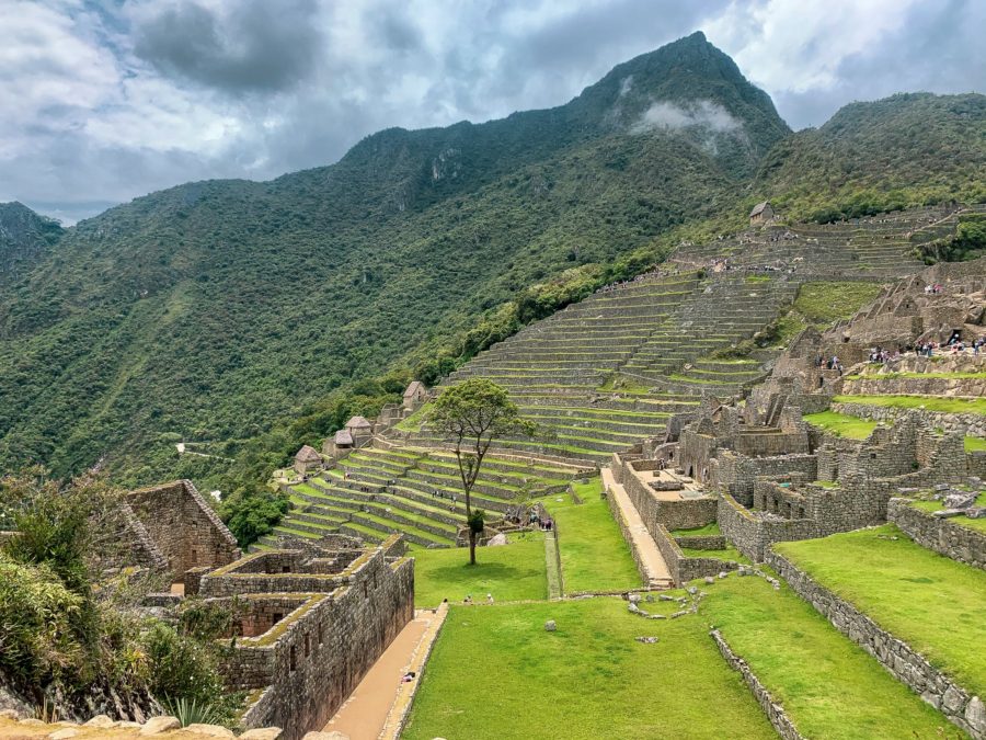
After leaving Marampata, you’ll notice those first views of the Inca terraces. These lower terraces are known as the House of the Waterfall. The trail continues past a bridge, which makes for a great place to rest and fill up on water.
Reach the Choquequirao Campsite, which is meant to be utilized for those continuing onto Machu Picchu. Set up camp and explore the massive Choquequirao ruins.
My Choquequirao to Machu Picchu Trek Day 2

- Santa Rosa Baja to Choquequirao Archaeological Park
- Distance: 5.25 miles
- Schedule: Left Santa Rosa Baja Mama Eufemia’s @ 8:15 with arrival at Choquequirao Campsite @ 13:00
- Highlights:
- Uchuhuerta Waterfall
- Incredible viewpoints of the River Valley
- Marampata Village
- Exploring Choquequirao
- Tips: Sleep in Marampata village to have ample time to explore the sprawling ruins of Choqueuiqrao or leave really early from Santa Rosa Baja
Explore the Choquequirao Archaeological Park
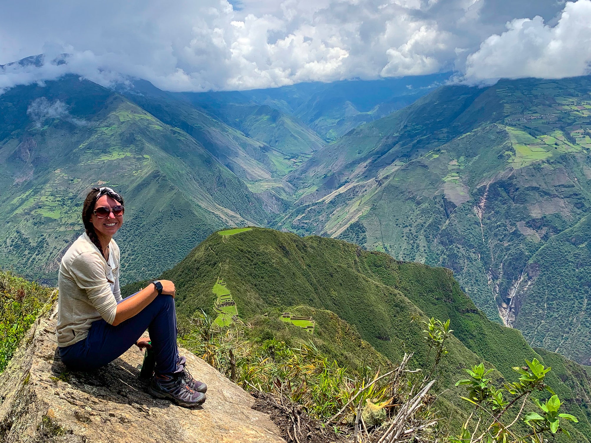
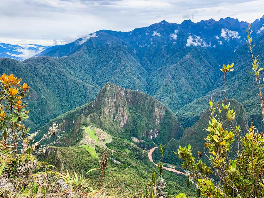
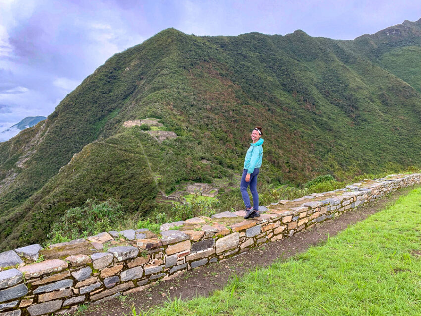
A highlight of the Choquequirao to Machu Picchu trek is undoubtedly the Choquequirao Archaeological Park. The Choquequirao site is one of Peru’s least visited Inca sites, but one of the most spectacular. This sacred site oftentimes sees less than 20 visitors a day. Choquequirao still remains an untouched “hidden gem in Peru.”

The Choquequirao ruins are one of the most incredible Inca sites in Peru.
Highlights include the Pikiwasi, House of the Priest, and Usnu. These sections of the park boast some incredible views. Explore the hauntingly empty Plaza Principal. Don’t miss the Llama terraces and the area above the main Plaza, Q’olq’as.
For those spending an extra day, backtrack to visit the House of the Waterfall terraces that were visible the previous day.
☛ Love untouched sites like this? Don’t skip the incredible Waqrapukara Inca Site
There was no one on-site checking tickets, but make sure to carry it just in case someone approaches you for your ticket. Be mindful of the closing time. The park closed while we were inside it, even though we were at the gates before 17:00. It’s possible to slide out the side of the gate if you have good balance.
Camping at Choquequirao Campsite
The Choquiequirao Campsite is meant to be reserved for those hiking onwards to Machu Picchu. From what I encountered, this was not being enforced during my visit. There are a few grassy terraces to set up camp.
We came on the shoulder of the rainy season, so our biggest challenge was finding an area that was not too saturated with mud.
- Camping here is free and included with the purchase of the entrance ticket.
- These facilities are nice with cold showers, changing areas, toilets, and a separate sink area for dishes.
- There is a small hut where there is a limited selection of food for purchase. Make sure to have food and gear if camping at Choquequirao
Useful Tips for Visiting Choquequirao Ruins
The lost city of Choquequirao is massive and it is possible to spend at least two or three days exploring the park. Those who are hiking the intense Choquequirao to Machu Picchu trek should understand the next section of the trail is remote and offers little shade coverage.
Plan on an extra cushion day if looking to explore an extra day at the ruins.
Those taking the Choquequirao to Machu Picchu trek should leave early and not spend more than a few hours in the morning at the park on Day 3. This is to beat the hot afternoon sun and give ample time to cross the river. Additionally, it’s advised to continue onwards to Maizal, which adds on a steep 2.5-mile climb (almost three hours).
When ready to leave the Choquequirao ruins, there will be a steep climb to the epic viewpoint of Abra Choquequirao (10,735 feet). After that, pass by the empty Pinchaunuyoc ruins. This is another great option to camp as the River campsite is no longer an option to sleep at.
It’s best to pack up gear last minute from the campsite, so you don’t have to lug it around while exploring the Choquequirao Archaeological Park.
The next leg will depart the Choquequirao ruins and meet up with the Salkantay trek.
Choquequirao to Machu Picchu Trek Part 2 | Choquequirao Ruins to Salkantay Trek

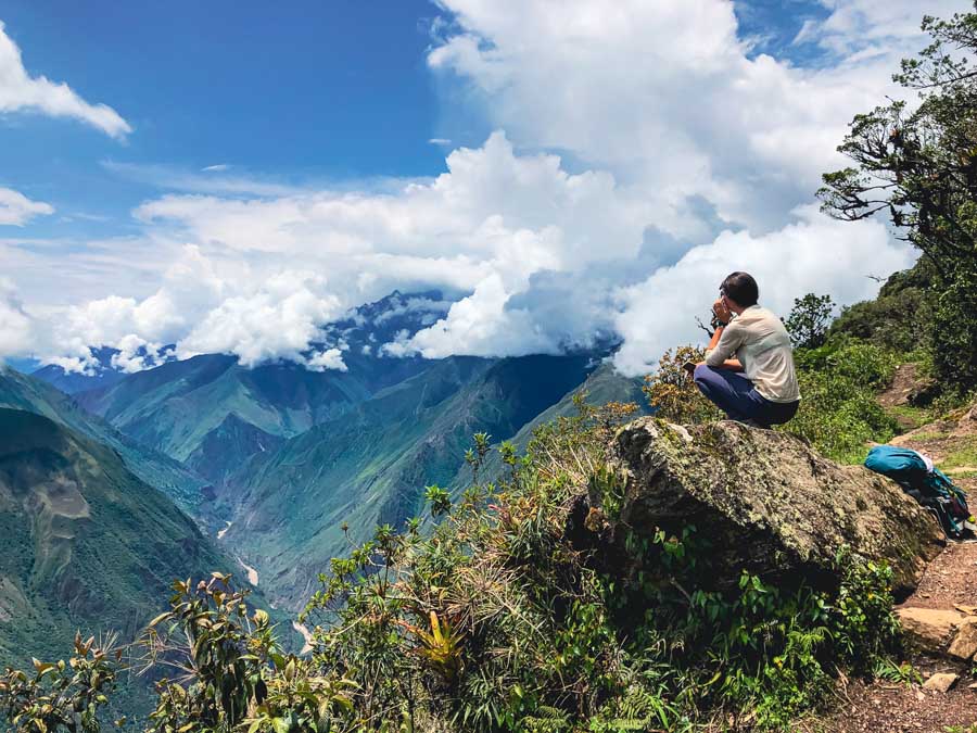
This next leg of the Choquequirao to Machu Picchu trek is true expedition mode. The section from the Choquequirao ruins to the Salkantay Trail was by far my favorite 3 days of this grueling trek.
Prepare for some epic viewpoints, empty paths, scattered ruins, and no people. We didn’t see a single soul on this section of the trail, not even locals.
There will be plenty of donkeys and horses along the trail, so watch out for those who are protective of their space.
⁉️ Important Safety Notice | Be mindful that during the Cusco rainy season, from November to April, it may not be possible to cross the White River between Choquequirao and Maizal as the river may be too high. January is usually the wettest month in the Cusco Region. Check-in with the Choquequirao gatekeepers to see if the river is passable, or has dangerous conditions. If the river is too high, the Choquequirao to Machu Picchu trek is impossible.
Day 3 & 4 | Choquequirao Ruins to Yanama

Be mindful that there is no longer a river campsite, so you’ll need to camp at Pinchaunuyoc ruins or cross the river and camp at Maizal (recommended).
The total distance from the Choquequirao ruins to Yanama is 13.5 miles and must be divided between two days. This makes Maizal a great option to sleep.
The trailhead from Choquequirao to the Machu Picchu trek is a half mile from the campsite. Before the main entrance gate to Choquequirao, look for a makeshift sign for Yanama. There is only one path to follow and this is it! It’s a little bit of a climb, but the views on the way out will take your breath away!
Try to leave Choquequirao extremely early to avoid the afternoon hike and cross the river. The river is around a 5-hour trek and includes an ascent and descent.
The next highlight is the Abra Choquequirao viewpoint, which is an incredible photo opp that sits at 10,735 ft. This viewpoint boasts spectacular views of Choquequirao. Once you reach this pass viewpoint, it’s onward to the remote villages until the Salkantay trek.

🥾 Choquequirao ruins to Abra Choquequirao | Distance: 1.25 miles | Duration: at least an hour
After the Choquequirao Pass the trail begins to mostly go downhill.
The next main highlight is the leveled terraces of the Pinchaunuyoc ruins. These unique Inca terraces are spectacular and boast a water spigot to refill water bottles. If you can’t continue onwards, this makes a great option to camp.
Spend time at these isolated ruins and continue downhill towards the river.
The trail leads to the rushing river. This section will continue to modify and change with all the landslides from the mountains.
The trail up the mountain is very apparent. It’s easy to lose the trail across the river, but people have set up little rock formations for guidance

Eventually, cross the river via a small wooden footbridge. These can be pretty dodgy, so always use caution.
Once across the river, you’ll need to follow the uphill trail to Maizal. Make sure you have enough time to reach Maizal before dark.
🥾 River Crossing to Maizal | Distance: 2.5 miles | Duration: +/- 3 hours
Be mindful as you leave the White River of the severity of the climb, as the ascent is basically for every one mile of distance to a one-mile ascent. It’s brutal and there is little shade coverage along the way.
In Maizal there are two campsites, Camping Familia Perez and Camping Señor Valentin. During the high season, both campsites should be open. There are few food options, so this is where the cooking gear comes in handy.


Camping Familia Perez is more directly en route to Yanama where Camping Señor Valentin is off the route a bit.
The campsites have basic facilities like water and bathrooms.
Maizal to Yanama (Day 4)
For me, this is one of the most challenging sections, but sleeping in Maizal really helps break. up the grueling climb from the river to Abra San Juan (the mountain pass). San Juan Pass sits at 13,615 feet and leads to Yanama village.
The steep climb from Maizal to Yanama was one of the toughest (physically and emotionally) for me on the entire Choquequirao to Machu Picchu trek. The ascent is straight up, and the altitude climb is INTENSE.
Leave Camping Familia Perez to start the ascent to the Abra San Juan pass, which is a steep straight-up 3.25-mile climb. Plan on this section taking at least 5 hours.
This is the most challenging part of the whole trek, and it’s important to not push yourself too hard. Mind the altitude. Please be respectful of the altitude and your own body. Most tours provide oxygen tanks, but independent hikers don’t so take the proper precautions and rest when needed.
Along this trail section, there are many small trickles of water to fill up water bottles. There are plenty of places to break. We were starving and stopped more than once to cook pasta for body fuel.

The last climb up to San Juan Pass is not as steep as the previous section.
Abra San Juan pass sits at 13,615 feet and offers a simple shelter for those who can’t continue or get caught in severe weather.
The views are absolutely stunning with mountains dressed in glacial peaks. Even though it was cloud-covered, this was my favorite viewpoint of the whole Choquequirao to Machu Picchu Trek.
From Abra San Juan, it’s a comfortable downhill trek into Yanama village. Be mindful of this section of the trail as the path is extremely narrow and drops down the valley. We saw a minor rock slide happen in real time.
This last stretch is about 1.75 miles on a beautiful downhill dirt path into Yanama. Once in Yanama, find Camping Choquequirao located on the main road. This is an untouched and authentic village in the Andes Mountains.
Sleeping at Camping Choquequirao

The man running Camping Choquequirao is so sweet! The rooms are simple, but there are plenty of blankets for the cold mountain nights. Onsite, find a tienda with extremely reasonable and fair prices. This is an excellent place to stock up on snacks before the Salkantay Trail.
Right next door a woman serves up hearty plates of food from her home for 10 PEN ($3 USD). The food is authentic and rotates. We had duck!
Camping Choquequirao | Bed in Shared Room: 15 PEN per person | Hot Water Fee: 5 PEN (Worth it) | Food and Snacks available for purchase at a fair price | Basic Facilities & Free Charging |The man who runs this guesthouse is so sweet and cares that you enjoy your stay
My Choquequirao to Machu Picchu Trek Day 3 & 4
My mileage is different because I camped next to the river and this is no longer an option. The total distance is 13.5 miles from the Choquequirao ruins to Yanama. Here’s what these two days looked like for me.
To reach Maizal you’ll have to leave Choquequirao early in the morning, so plan accordingly.
- Choquequirao Ruins to River Crossing: 6 miles
- Schedule: Left Choquequirao @ 11:30 with arrival at the river campsite @ 16:30 (5 hours)
- Highlights:
- Morning quietness at Choquequirao
- Incredible viewpoints of the ruins from Abra Choquequirao (10,735 feet)
- Pinchaunuyoc ruins
- River Crossing to Yanama
- Distance: 7.5 steep uphill climb
- Schedule: Left River @ 6:40 with in Yanama @ 16:45 (10 hours)
- Highlights:
- View from Camping Familia Perez
- Incredible viewpoint from Abra San Juan pass
- Stunning mountain views of the valley into Yanama
- Excellent guesthouse at Camping Choquequirao
- Home-cooked duck dinner in a local woman’s home.
Day 5 | Yanama to Totoro


The hike from Yanama to the Totora community is another gorgeous day. This trail mostly follows the lush valley along the river. There are plenty of places to break and refill water bottles, but make sure to purify the water as there are lots of cows in the valley.
The tallest pass of the Choquequirao to Machu Picchu trek today happens at the Abra Mariano Llamoja Pass. This pass isn’t as intense as yesterday, and it’s more of a gradual incline.
Totora is a small hamlet with a few houses and is the last community before merging with the Salkantay Trail.
Day 5 | Morning Schedule (Yanama to Abra Mariano Llamoja)
Try to leave early if you can as there is little shade or protection from the elements. We had heavy rain which held us up a little bit in the morning.
The path mostly follows alongside a road, but there are sections where you must walk on the road. Use the hiking paths, especially the switchbacks! It helps cut down time and distance.
Today the uphill climb is gradual and provides beautiful views of the green mountains.
This path was harder to follow, so it’s best to follow along with Maps.me or any other offline map. It’s easy to stray, as you’re walking through mostly farmland.

Refer to the above photo, make sure to walk behind the shelter to stay on the path! After the shelter, you’ll come to the main river crossing. Once you cross the Yanama River here you’ll start the uphill trek to Mariano Llamojo Pass.
We made it to the river crossing in 3 hours and 15 minutes from Yanama. Since it’s right before the major ascent, it makes for a great place to have lunch! The green mountains with tiny waterfall crevices are a spectacular backdrop.
Cross the river to begin the gradual climb up to Abra Mariano Llamoja at an altitude of 15,289 feet (4660 m). It’s about a mile climb to reach Abra Mariano Llamoja from the river. Plan on this climb to take almost 1 hour 15 minutes to reach the top with no break.
There’s an option to climb to the actual top peak, but due to the fog and rain, we skipped this. There was zero visibility.
Day 5 | Abra Mariano Llamoja to Totora


The next section of the trail is the start of the downhill to Totora. Follow the footpath and not the road. The road has many switchbacks which will add extra time, so follow Maps.me for the most convenient path down.
Mind your footing. On the way down the terrain is mostly large rocks with lots of gravel. Due to the altitude and rain, it can be very slippery.
From the pass of Abra Mariano Llamoja to Totora is a little over 4.5 miles. This section moves pretty fast and takes about 2.5 hours.
Peek over your shoulder every once and a while to awe at the beautiful rigid mountain peaks behind you!
Totora is a small community with literally 6 homes. Do sleep at Camping Sumaq Tika for an awesome experience.
Sleeping at Camping Sumaq Tika
The rain moved in fast and we were soaking wet! We opted again to sleep at Camping Sumaq Tika. There was ample room to camp here, but the whole yard had been washed away and was nothing but a mud pit. There is a small tienda connected to this guest house, but the prices are a little higher than Yanama.
The rooms here are extremely basic, as in, it’s a concrete room with beds. There are plug-ins hanging from the ceiling, but, hey… they get the job done.
The woman sells beautiful handicrafts for a fair price, and she is a hustler! This woman is a powerhouse. She makes dinner and this was seriously one of the best meals I have eaten in all of Peru. Order dinner here!
Camping Sumaq Tika | Private Room: 15 PEN per person | Hot Water Fee: 7 PEN (Worth it) | Food and Snacks available for purchase | Basic Facilities & Free Charging | WiFi Fee: 10 PEN | Lots of Blankets | Woman sells beautiful handicrafts | Awesome and hearty meal for 10 PEN | The family that owns this place are real characters, but in a good way
My Choquequirao to Machu Picchu Trek Day 5
- Yanama Community to Totora Community
- Distance: 12.25 miles
- Schedule: Left Camping Choquequirao @ 8:00 with arrival to Camping Sumaq Tika in Totora @ 16:30 (8.5 hours)
- Highlights:
- My second favorite day
- Incredible views along the Yanama River
- Excellent place to cook lunch and break along the river
- Highest Pass of the Trek at Abra Mariano Llamoja (15,289 feet)
- Lovely views into Totora that follow along the river
- Hands down the best meal on the trek from the women at Camping Sumaq Tika.
Choquequirao to Machu Picchu Trek Part 3 | Join the Salkantay Trek to Machu Picchu

After leaving Totora, the next main milestone will be connecting to the Salkantay Trail in the village of Collpapampa. We came during the rainy season, so the Salkantay Trail was really muddy and had lots of mudslides, which were not passable.
This changed our route drastically, as we had to follow the road on the opposite side of the river. On this side of the river, there were limited sleeping places. For this reason, we made the long trek into Sahuayaco. It is less scenic and a little longer than the main trail.
If attempting during the shoulder or rainy season, make sure to be aware of your surroundings. One of the bridges collapsed on our route and unfortunately, someone was taken down the river. This area sees a lot of rain.
One Note About Joining the Salkantay Trail
One downfall of the Choquequirao to Machu Picchu trek is missing the incredible Humantay Lake. This popular destination is on the first day of the Salkantay Trek. It was a downer to miss it, but it can always be done as a day trip from Cusco.
I justified missing this section with the incredible and untouched landscapes from Choquequirao to Totora.
Day 6 | Totora to Sahuayaco via the Salkantay Trek

The trail from Totora to Collpapampa is a casual and welcomed downhill descent. The path follows a gravel road but offers nice river views. Once arriving in Collpapampa, you’re officially joining the Salkantay trek.
🥾 Totora to Collpapampa | Distance: 4.75 miles | Duration: 2 hours
In Collpapampa, turn left to join up with the Salkantay Trail. This route is extremely well-marked and trekked. We were fortunate to only see a few independent hikers and no tour groups.
This trail passes by many little waterfalls with wooden makeshift bridges. There may be sections that are impassable due to landslides.
Oftentimes, the shop owners will alert you if the trail has gone down. We went to the landslides and decided that we did not have the proper gear or equipment. It was not worth the risk to attempt to cross.
Due to the rainy season, we had no choice but to use the pulley trolley system to cross the river.
The price is negotiable, but it’s hard to do screaming over a river. There really is no option but to take the pulley system unless you want to retrace the mileage along the river.
This cart was 4 planks and only one person can cross at a time. Two men literally yank you and your bag over the river at a shocking height. We negotiated for 10 PEN a person. I think we got a deal because my hiking partner helped carry lunch over for the workers!

Since we had to cross the river due to a landslide, the path is mostly flat along a boring road. This will add extra miles but make Sahuayaco a welcomed village to sleep.
The path we took was not ideal or normal, so it turned into a long day.
We set up camp at El Mirador in Sahuayaco.
If you have enough energy it’s possible to continue along the trail past Kilometer marker 57 and sleep at one of the incredible lodges or guest houses in the coffee region.
Sleeping at El Mirador in Sahuayaco
We opted to sleep at El Mirador in Sahuayaco, which is on the outskirts of town. El Mirador has a really nice green space that overlooks the village of Sahuayaco. It’s close to the coffee region of the Salkantay trek, so most places are serving up excellent coffee.
There are lots of clotheslines at the site, and the owners even provide soap to wash clothes. Check out the onsite tienda that’s well stocked and serves up simple sandwiches for purchase.
Three houses up the the road there’s a little restaurant serving large plates of food for 10 PEN.
El Mirador | Camping: 7 PEN | Rooms available to rent | Gourmet Coffee & well-stocked tienda | Clean Basic Facilities | WiFi Available for Purchase | Free laundry soap & clotheslines | Hot water included in fee
Sahuayaco is one of the biggest villages along the Salkantay Trek, so there are plenty of tiendas, cafes, and restaurants to refuel at than most places along this trail.
My Choquequirao to Machu Picchu Trek Day 6
- Totora to Sahuayaco
- Distance: 14 miles but we trekked more due to the landslide detours
- Schedule: Left Camping Sumaq Tika @ 8:00 with arrival to El Mirador Campsite @ 15:30 (7.5 hours)
- Highlights:
- Meet up with the popular Salkantay Trail in the little village of Collpapampa
- Cute little tiendas in nature along the path
- Crossing the river via a pulley cart
- Mostly flat hike
- El Mirador Campsite in Sahuayaco
Day 7 | Sahuayaco to Llactapata Lodge


Today is a pretty short and enjoyable day. It starts with leaving Sahuayaco and staying at the incredible Llactapata Lodge. Don’t miss a chance to stay here, as it was definitely one of the highlights of the Choquequirao to Machu Picchu trek.
Enjoy a coffee at El Mirador before continuing on the Salkantay Trail. At Kilometer marker 57, which is only a 30-minute walk from Sahuayaco, head up the leafy green path that twists through the coffee region.
The climb is gradual and not as intense as the last few days. We stopped at Camping Inka Andino & Coffee Tour to have a “Starbucks Coffee.”
One of our first glimpses of Machu Picchu and its incredible mountains was at Mesa Pata Observatory and Camping. Plan on about 3 hours from Sahuayaco to the viewpoint. Mesa Pata Observatory and Camping serves up a limited menu but has beverages for purchase.
From this point, it’s a gradual descent to the ruins of Llactapata and only a half mile from Mesa Pata
These small Inca ruins of Llactapata, provide some of the first glimpses of the iconic Machu Picchu Mountain. They may just take your breath away.
Next, continue only a half mile down the trail to arrive at the epic Llactapata Lodge. This lodge offers some incredible views, wild horses, proper guest houses, delicious food, and lovely hosts.
Whatever you do, stay at the Llactapata Lodge, a true highlight of this trek.
Sleeping at the Llactapata Lodge

Llactapata Lodge is a proper hotel and lodging facility, but there is camping available, as well. The meals are huge and delicious and there is WiFi available for purchase.
The views really don’t get better than this. At night, we watched a lightning storm over Machu Picchu. At dinner, we lost electricity and ate dinner by candlelight. Yeah, this lodge is magic.
Wake up early in the morning to catch the sun waking up Machu Picchu in the distance.
Llactapata Lodge | Camping: 5 PEN & includes hot water and shower! | Rooms available to rent | Clotheslines & Open Grassy Spaces | Super Clean Facilities | WiFi Fee: 5 PEN | Dinner: 20 PEN and includes tea, hot chocolate, salad, main, and is filling and delicious laundry soap & clotheslines | Dogs and Horses Running Wild
Technically, it’s possible to push the last day all the way to Aguas Calientes, but I really recommend sleeping here
My Choquequirao to Machu Picchu Trek Day 7
- Sahuayaco to Llactapata Lodge
- Distance: 7 miles
- Schedule: Left El Mirador Campsite @ 9:00 with arrival at Llactapata Lodge @ 14:00 (5 hours)
- Highlights:
- Passing through the coffee region
- Those first distant viewpoints of Machu Picchu
- Small ruins of Llactapata
- Camping at the Llactapata Lodge with its incredible views, amazing staff, and delicious food
Day 8 | Llactapata Lodge to Aguas Calientes

Wake up early to catch the sunrise before departing Llactapata Lodge. Today’s trek is pretty uneventful and not as beautiful, but it’s literally all downhill! The whole goal is to make it to Aguas Calientes, or Machupicchu Pueblo, at a decent time in order to explore Machu Picchu the following day.
Take the trail downhill, turn left, cross the river, and continue to the little makeshift village where the train tracks and the Hydroelectric Plant are found. Plan around 2 hours to reach this area from Llactapata Lodge.
Next, you’ll see the Machu Picchu Ticket Control Area. There was no one there to check us in, but there were pens to sign yourself in. Now’s the time to dump plastic water bottles and bags in the trash.
Important & Helpful Notes
- No outside plastic bags or plastic water bottles are allowed at Machu Picchu Archaeological Park, dispose of them upon entering.
- Be mindful of the trains coming around the corners while following the tracks.
- There will be lots of dogs walking happily along with you in this section.
Keep hiking along until you see a bunch of makeshift food stands and the train station. Try booth #6 on the left-hand side for 7 PEN plates of food & 3 PEN sandwiches.
Today is the day to follow the railroad tracks, which start at the Hydroelectric Plant of Santa Teresa. This is also the hub for collectivos back to Cusco and obviously, the trains run from here!


From the train station, it’s a long and uneventful 5-mile walk along the train tracks.
Walking along the train tracks is kind of a culture shock, especially if you have just completed the whole Choquequirao to Machu Picchu trek. There are so many people walking along the tracks, coming from every direction. Say goodbye to that serenity you had for the past 7 days.
The walk along the tracks takes around 2 hours to reach Wayna Picchu Camping.
There are some food stands right in front of the campsite selling snacks, bread, sandwiches, and other goodies.
For those camping, an excellent camping option is at Wayna Picchu, which is extremely close to the lower entrance gate of Machu Picchu. It’s a half mile before the village of Aguas Calientes. There are some rooms available for rent here.
Camping at Wayna Picchu
Wayna Picchu Camping is an excellent option for those just looking to sleep cheap and close to the bottom entrance control of Machu Picchu. From Wayna Picchu Camping, it’s literally a quarter of a mile to the control where they check your passport and ticket.
Remember, it’s an hour’s walk uphill from the lower entrance to the main entrance, so there’s still a climb the following day.
Wayna Picchu is eclectic and is right on the mighty river. There are roofs to set up tents underneath to help stay dry. Clean bathrooms, simple, but lots of places to relax and chill.
Wayna Picchu Camping | Camping: 15 PEN a tent | Lots of hammocks, green space, and tables | Next to the River | Simple Facilities but no hot water | Literally .25 miles from the lower entrance gate of Machu Picchu
My Choquequirao to Machu Picchu Trek Day 8
- Llactapata Lodge to Campsite before Aguas Calientes
- Distance: 8.75 miles
- Time: Left Llactapata Lodge @ 7:00 with arrival at Wayna Picchu Camping, just outside of Aguas Calientes @ 11:30 (4.5 hours)
- Highlights:
- Watching the sunrise at Llactapata Lodge
- Exploring Aguas Calientes
- Excitement levels running high to finally see Machu Picchu!
Arrival into Aguas Calientes (Machupicchu Pueblo)

On Day 8, you’ll arrive in Aguas Calientes or Machupicchu Pueblo. Decide on where to sleep. There are camping sites close to the lower entrance gate or add another 25-minute walk into the small village of Aguas Calientes.
Many people use Aguas Calientes as a base to explore the famed lost city, but the pueblo itself is quite touristic. There are a few fun things to do in Aguas Calientes besides Machu Picchu. After all that trekking you may want to plop down at the local Peru hot springs in the center of town.
Stay in Aguas Calientes
There are tons of great places to stay in Machu Picchu Pueblo for any type of budget.
➜ Supertramp Hostel Machupicchu has a great breakfast included with the price and serves it up starting at 4:00 a.m. It’s perfect for those with early morning entrance tickets to Machu Picchu.
➜ Runas Inn Machupicchu offers private rooms for a budget price and is close to the bus stop for Machu Picchu
➜ Peru Coca B&B Machupicchu has warm hosts and spacious rooms in Machupicchu Pueblos
➜ Panorama B&B has all the amenities you need and is one of the highest-rated places to stay in Aguas Calientes
➜ Jaya Suite Machupicchu offers mountain view rooms with a pinch of luxury
➜ Browse all the Best Places to Stay in Machu Picchu Pueblo
Tips on Staying in Aguas Calientes
The lower entrance gate is 1.5 miles from most accommodation options in Aguas Calientes. Be mindful that if using the lower entrance gate, it’s another 1 – 2 hour uphill climb to the main entrance gate.
There are bus transfers to the main entrance Gate of Machu Picchu, but the round-trip bus tickets are quite expensive.
Explore the Lost City of Machu Picchu | Day 9

Yeah!! You did it! From Cachora, through the Choquequirao ruins, to the Salkantay trek, and to the entrance gates of Machu Picchu, you did what few have done! The Choquequirao to Machu Picchu trek is a feat not many have accomplished. Hiking this 8-day trek to Machu Picchu makes the reward of gazing out over Machu Picchu a little more sweet.
Machu Picchu is by far the most iconic landmark in Peru.
Make sure to have your passport and entrance ticket and you are within the right time frame to enter! Those hiking up one of the mountains in Machu Picchu like Huayna Picchu or Machupicchu Mountain will have early entrance times, as the mountains shut down in the afternoon to climbers.
A Quick Itinerary Suggestion for Exploring Machu Picchu
Machu Picchu is beautiful with its llamas and alpacas roaming on stony terraces, powerful mountains in the backdrop, and crumbling ruins. There is so much to see and do in Machu Picchu alone. I won’t pretend to be an expert on this incredible site but only offer some quick advice and logistics.
- Hike up one of the mountains to get another perspective of Machu Picchu
- Early morning tickets and late afternoon tickets are best to avoid the crowds of day trippers
- With the new circuit tickets, you may wish to hike a mountain one day and then hike circuit 2 (the most complete circuit) the following day.
- Make sure to have tickets purchased upon arrival with your passport
Machu Picchu in a Day
Machu Picchu is extremely touristic, but I get the allurement of this magical city built in the clouds.
I hiked up to the main entrance from the lower entrance, climbed Machu Picchu Mountain, visited a majority of the Archaeological Park, hiked to Intipunku, and returned to the campsite from the main entrance.
Unfortunately, due to new regulations, the only way to hike to the Machu Picchu Inti Punku Sun Gate is via the Inca Trail.
The Inca Trail is highly regulated and can be hiked via the Classic Inka Trail or the Short Inca Trail for those with less time.
Guides are available onsite if you wish to join a tour. It is not necessary to use a guide to tour Machu Picchu.
Machu Picchu Archaeological Park | Hours: Daily, 6:00 – 17:00 | Lower entrance opens at 5:00 for arrival to the main entrance at 6:00 | Standard Ticket Price: 152 PEN ($41 US) | Ticket Price with Mountain: 200 PEN ($54 USD)
- Snack Bar and Restaurant available before ticket control
- Bathrooms available before ticket control
- Luggage storage available
My Day at Machu Picchu
- Distance: 20 miles… Be prepared to have a long day on your feet
- Highlights:
- All of it!
- Early morning entrance with barely any people
- Climbing Machu Picchu Mountain with only 6 people at the top
- The staff loves to blow whistles if you do the slightest thing wrong. That whistle will haunt your dreams tonight.
How to Return to Cusco from Aguas Calientes

From Aguas Calientes, it’s possible to return to Cusco via train by IncaRail or PeruRail. The cheapest way is to take a collective. Cusco has tons of awesome places to see and explore, like the Cusco South Valley, plenty of free Inca ruins, and of course, delving into the Cusco food scene is a must.
Psst… Check out these Unique Cusco Itineraries
Train
There are two train companies that run from Cusco to Machu Picchu and vice-versa. The two companies are PeruRail and IncaRail. Train fares can be simple to extremely luxurious.
Both rail companies stop in Cusco and the Sacred Valley. If opting to explore the Sacred Valley, the trains disembark in the charming village of Ollantaytambo. Sometimes there are mandatory transfers in Ollantaytambo in minibusses (collectivos) to Cusco.
Tickets start at $60 USD to Ollantaytambo and can run as high as $575 USD for a luxury ticket to Cusco on the Hiram Bingham.
Collectivos
Collectivos are the way to go for those on a budget. It’s a little more time-consuming and it isn’t as convenient or spacious as the trains, but it’s cheaper!
🚐 Hydroelectric Plant to Cusco Collectivo | Cost: Around 40 PEN | Duration: 5 – 6 Hours | The ride is beautiful, grab a window seat if you can | Collectivos drop in multiple stops, verify with your driver the drop-off location | Most will drop near the Cusco San Pedro Market
- Walk back along the railroad tracks to the Hydroelectric Plant. An uneventful 5 miles that takes around 2 hours from the lower entrance gate of Machu Picchu.
- If you walked from the Salkantay Trek you saw the collectivos waiting at the “end of the railway tracks.”
- Collectivos depart when full.
- Collectivos may require a transfer in Santa Teresa, Santa Maria, or Ollantaytambo.
- It’s possible to get out at any of these spots.
- Santa Teresa has hot springs
- Ollantaytambo is the gateway to, in my opinion, the unmissable Sacred Valley
The Incredible Sacred Valley
Do not simply skip by the magical Sacred Valley in Peru. There are picturesque villages like Ollantaytambo that offer some of the best hikes in the Sacred Valley. Visit the Pumamarca ruins or take the strenuous climb up to the Inti Punku Sun Gate of Ollantaytambo.
Down the road are hidden gems like Ñaupa Iglesia and the Perolniyoc Waterfall.
Urubamba may be the most underrated village in the Sacred Valley. The authentic village boasts hikes to the peculiar pillars of Saywa Mountain and a colorful weekly market.
Purchase a Cusco Tourist Ticket and visit the unique Moray ruins. It’s possible to hike from the Maras Salt Miles to the Moray Ruins.
There are the spectacular ruins of Huchuy Qosqo that see little tourists or go on an adventure to soak in the Lares Hot Springs.
Pisac is one of the most beloved villages in the Sacred Valley with its bohemian vibe, hilltop ruins, and day hike to the sparkling Kinsa Cocha Lakes.
☛ Psst.. This is the most complete guide to the Sacred Valley in Peru


Total Cost of Choquequirao to Machu Picchu Trek
So how much did this whole adventure cost me? Here’s a breakdown from Cusco to Cachora, to visiting the Choquequirao ruins to my final destination of Machu Picchu.
| Expenses | PEN (S/) | USD($) |
| Food & Snacks (First 4 days, split between 2 people) | S/60 | $17.50 |
| Propane Tank Large (Best to have another small for backup) | S/40 | $11.75 |
| Bus & (Taxi, 2 person split) to Cachora | S/18.25 | $5.25 |
| CasaNostra Choquequirao & dinner with drinks and upgraded breakfast | S/60 | $17.50 |
| Campsites (split between 2 people) | S/13.50 | $4 |
| Guest House Rooms | S/30 | $8.75 |
| Hot Water Fees | S/12 | $3.50 |
| Snacks along the trail | S/25 | $7.25 |
| Prepared Meals & Coffees | S/60 | $17.50 |
| Replenishment of Food Supplies | S/25 | $7.25 |
| Wifi & Charging Expenses | S/15 | $4.25 |
| Choquequirao Archaeological Park Ticket | S/60 | $17.50 |
| Pulley cart on the Salkantay Trek | S/10 | $3 |
| Machu Picchu Ticket with MP Mountain (Old Price Structure) | S/275 | $80 |
| Aguas Calientes Hot Springs | S/20 | $5.75 |
| Collectivo to Cusco | S/40 | $11.75 |
| TOTAL EXPENSES | S/763.75 | $222.50 |
This daily average is $22.25 per person to complete the Choquequirao to Machu Picchu trek. My budget was based on 10 days.
The biggest expenses are the entrance ticket fees to Choquequirao and Machu Picchu
Want to Lower Expenses?
The Choquequirao to Machu Picchu trek can be done cheaper by camping every night, buying fewer snacks and prepared meals, not using WiFi, and having cold showers! In Cachora, skip dinner at the hostel!
Remember, it’s nice to purchase meals and sleep in the local guest houses.
Choquequirao to Machu Picchu Trek | A Real Expedition

In conclusion, this is the complete guide on the Choquequirao to Machu Picchu trek. This trek is off the beaten path, and when done independently, it can feel like a real expedition. Adventure through authentic villages, experience quiet ancient Inca ruins, climb between scenic mountain passes, and feast your eyes on the ultimate prize, the lost city of the Incas, Machu Picchu.
The Choquequirao to Machu Picchu trek is a challenge, but the journey truly is the genuine reward.
This 10-day itinerary covers all important aspects from how to get to Cachora, the starting point of the Choquequirao trail, trekking maps, day-by-day itineraries, tips and tricks, visiting Machu Picchu, how to return to Cusco, and budget of this trek.
Have you heard of the Choquequirao to Machu Picchu Trek? This Choquequirao to Machu Picchu trek guide has recently been updated by incredible readers like you! If you know of any new updates for this trail, please email me or let me know in the comments below!


Disclaimer: There’s a chance this post contains affiliate links, and I receive a small (but grateful) portion of the sale. There’s no extra cost to you, and I only promote things that I use and love.


What an epic adventure. I’m actually planning my first multi day hiking trip close to home this year, but this is something to work up to for sure. Something I’ve always wanted to do.
Thanks Emma! Good luck on your first multi-day trek. Thanks for reading!💚
Wow this is an excellent guide with so many useful tips! I had planned on hiking Machu Piccu this September and hoping I can get there in 2022. I had never heard of this stretch but now I’d like to do this too. The views of the terraces and ruins are gorgeous!
Thanks so much Vanessa! This is a very “off the beaten path trek,” and Choquequirao is just as stunning. The final reward of Machu Picchu is SO worth it! Best of luck and please let me know if you choose this route! Happy trails. 🥾
This is awesome! We wanted to do this this summer! Thanks so much for sharing your experience!
That’s awesome Kelsey! I hope you enjoy it and would love to hear your experiences! 🥾
This looks incredible! And what a thorough post! This is on my bucket list!
Thank you so much Andrea! It has been one of my favorite multi-day treks of all time. 🏔
Wow so informative! I don’t know how anyone does this hike without reading this post, thanks so much!
Awe thank you, Jessica! I hope this helps anyone looking to take this “off the beaten path” trek! 😊
This post is incredibly informative! I love a long distance hike and this has always been on my bucket list.
Thanks Nell! Hope you can tackle this epic hike in the near future! 💚
Hi Megan, thank you so much for the informative post! That helps a lot in our planning for the trek this summer. In which year did you do the trek? (Conditions can change so quick in a few years)
Thank you, Sophia
Hey Sophia-
I completed this trek in December 2019, right before COVID shut down Peru. Yes, trail conditions can always change and it’s important to have up to date information. There is only one trail from Cachora to Choquequirao and then Choquequirao to the Salkantay trail.
I suggest reaching out to the campsite right at the trailhead of Choquequirao, Choquequirao Wasi. The owner is a guide and offers his services. The gatekeepers can also assist in sections of the trail that can be shut. If walking during the rainy season, be mindful that the trail can close due to landslides and rockslides. Always check-in with a verified service.
I only offer my experience as many of the blogs I found only wrote about the trek… but never had actually trekked it.
The local guides are incredibly helpful.
Safe hiking,
Megs