Monte Pindo Hike One of the Most Mystical Mountains in Galicia
Galicia Spain has their own language, typical music (usually featuring their form of bagpipes called gaita), and deep roots with Celtic traditions that stem from Pagan settlements. One of the most sacred places in Galicia is Monte Pindo, sometimes called the Mt. Olympus of Spain.
This sacred mountain is where their ancient Gods lived alongside the giants.
Monte Pindo is filled with huge boulder stones, many of which resemble humanlike figures and animals. The energy is truly spectacular and most locals will tell you that the “veil is thin” at the top. The summit of Monte Pindo is 2,057 ft (627 m) and is referred to as Moa. In Galicia, the name translates to molars as there are unique natural rock formations that kind of resemble human molar teeth.
Monte Pindo is a special place in Galicia that is filled with beauty, myths, legends, and magic.
Here’s how to visit and hike this unique mountain on Spain’s Death Coast.
Table of Contents
Disclosure: This is part of my Hikes & Adventures series, which means these treks can be strenuous and challenging. These are my experiences and I am not an expert. Please have all the proper equipment, verify the weather conditions, use professional resources, do your own research, be mindful of constantly changing trail conditions, and take into consideration your own physical abilities and/or limitations. These guides are for entertainment purposes only. Please see my full disclosure for more information here.
- Monte Pindo Hike Map & Overview
- Where to Stay in Galicia to Hike Monte Pindo
- How to Reach the Trailhead in O Pindo
- History of Monte Pindo
- Hiking the Celtic Mount Olympus of Monte Pindo
- Options to Hike Down Monte Pindo
- Tips for Visiting & Hiking Monte Pindo
- What to Do After Hiking Monte Pindo
- How to Return to Cee
- Conclusion | Hiking the Mystical Monte Pindo
Monte Pindo Hike Map & Overview
There are many routes to hike Monte Pindo. There are official signboards in O Pindo and O Fieiro.
This map follows the recommended out-and-back trail from Pindo, but the waypoints of the alternative trail to O Fieiro are also highlighted on this map.
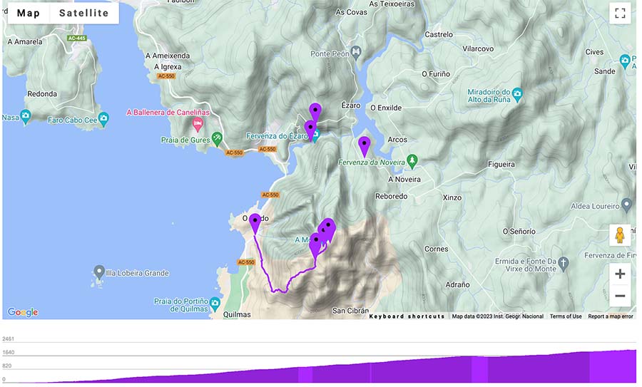

Overview of Out & Back Monte Pindo Hike Route
- Out & Back Trail
- This map follows the out-and-back trail from Pindo, but another option is the point-to-point trail from either Pindo to Fieiro.
- Official Trail Markers: The route does have yellow and white rectangles (Blazes), with scattered green signboards along the way.
- Difficulty: Moderate- Challenging, due to the rocky trail and ascent
- Some stretches of the trail have steep ascents and are not always clearly marked
- The trail is sometimes stoney and can be extremely slippery in the rain. Take care with your ankles and knees
- Distance Pindo to A Moa One-Way: Around 2.8 Miles (4.5 Km) | Out & Back 5.6 Miles (9 Km)
- Alternative Route Pindo to Fieiro: 5.2 Miles (8.4 Km)
- There are no transportation options in Fieiro. You’ll need to walk on the road to Ezaro (add almost 3 miles)
- Alternative Route Pindo to Fieiro: 5.2 Miles (8.4 Km)
- Excursion Duration: 4 – 7 hours, dependent on route, weather, stops, speed, etc
- Monte Pindo is best to hike during the summer and shoulder season. Winter in Galicia can be extremely wet, rainy, and windy. In the summer, start in the early hours of the morning to avoid walking in the intense sun as there is little shade coverage.
- Essentials for Day Hiking Monte Pindo
- First-Aid Kit
- Small Day Hiking Backpack
- Water in a Reusable Water Bottle and plenty in reserve
- Trekking Poles if you love them
- Hiking Boots or trail runners
- Offline Monte Pindo Hike Map from some source
- Extra Battery Pack for electric devices
- Layered clothing and hiking pants for some of the overgrown parts of the trail
- Euros for buses, cafes, and restaurants
➯ Hey… don’t forget your Travel Insurance! I love SafetyWing
Where to Stay in Galicia to Hike Monte Pindo
Many visitors who opt to hike Monte Pindo stay in Cee or the popular village of Finisterre as they are walking the Camino Finisterre Muxia. The easiest way to reach the trailhead via public transportation is in the small and picturesque village of O Pindo.
I love sleeping in Cee and have stayed on two separate occasions here. On top of numerous places to stay from albergues and hotels, the city feels lived-in with tons of restaurants, cafes, bars, and a proper bus station.
With so many amenities and awesome day trips, Cee is worth visiting.
Albergues in Cee
- Albergue Tequeron
- Albergue O Bordón (Cee)
- Albergue A Casa da Fonte (Guzman and his family are amazing hosts and happy to give tips on hiking O Pindo)
➜ Browse all the Best Places to Stay in Cee
Ezaro is also a nice place to stay, which is more quiet than Cee. There are a few accommodation options in O Pindo, but it’s even quieter than Ezaro.
How to Reach the Trailhead in O Pindo

There are frequent buses that depart from the Cee main bus station that drop close to the trailhead in O Pindo. Always arrive early to the station and purchase tickets from the bus driver.
🚐 Cee to O Pindo | Bus Company: Monbus (XG817) | Cee Central Bus Station | Duration: 15 minutes | Bus Ticket Price: €1.55 | Check the Monobus Schedule here
MonBus Schedule Peak Season (Cee Bus Station)
This Bus runs between Cee and Santiago de Compostela.
| Departure Time (Cee) | Schedule |
| 7:20 | Monday – Friday |
| 8:40 | Monday – Friday |
| 10:05 | Daily |
| 12:05 | Daily |
| 15:20 | Monday – Saturday |
| 17:05 | Daily |
| 19:05 | Daily |
☛ This is also a helpful website for using public transportation in Galicia Spain
Verified taxis also run between Cee and O Pindo, but the price starts at around €20. Always check at the official taxi stand and negotiate the price before entering.
Alternatively, if visiting by car, there is a free parking lot at the O Fieiro trailhead.
History of Monte Pindo


Monte Pindo was a sacred place for the many pagan tribes that called Galicia home years before the Romans ever arrived. It is often nicknamed the Mount Olympus of Spain, as it was said to be home to Celtic Gods, and giants, and has its fair share of legends and myths. The energy here is definitely powerful, and like all sacred places, it deserves respect.
The Pagan communities were said to have made “Camino routes” that followed the Milky Way as early as the 3rd century BC, although maybe it was much earlier. They were believed to be fertility routes where couples could visit healers and those who knew sacred medicine (always women) in the caves along the hillsides.
As this is one of the tallest and most unique rock structures on the Costa do Morte (Death Coast), it was probably a pilgrimage route in its own sense.
Along the way are said to be remnants of old and ancient churches.
Camino History of Monte Pindo

If walking the Camino de Santiago, especially the Camino Portuguese Way or the Camino de Invierno there’s no doubt that you’ve heard of Queen Lupa as she is mentioned in the story of St. James and the burial of his body.
On the Camino de Invierno, it’s possible to hike the legendary Pico Sacro. If you walk or take the Camino Espiritual route via boat to Padrón you can follow the the way of the stone crosses that Saint James took after death.
Little is known about her, except she was a Pagan Queen who ruled over Galicia who was said to surround herself with wolves, bears, and wild animals. Some wonder if she was real, or a fabled character to help with the conversion of Christianity in the Pagan region of current-day Galicia.
Queen Lupa was said to reside in Castro Lupario, but she may be buried somewhere in Monte Pindo with a treasure. The giant stone sculptures that resemble humans are said to be stone warriors protecting her. As she is often cast as a “villain” some go as far as to say that she turned the giants to stone.
Get Inspired to Walk the Camino de Santiago Pilgrimage Route
Interested in walking the Camino de Santiago or in the early planning stages?


Witches of Monte Pindo & The Spanish Civil War
Galicia is also known for their witches. There are two types: brujas and meigas. While brujas are known as more evil witches, meigas were said to be wise, healers, and of benevolent nature! Although some legends say they had some kind of deal with the devil, almost all of them used their powers for good.
Meigas were often single and rebellious and against the system and were sometimes called the first feminists! Meigas are also said to live in the caves found in Monte Pindo and maybe they still do…..
☛ Psst… The coastal village of Combarro in Galicia is a charming village where the presence of Miegas can still be seen
In more modern times, Monte Pindo was a refugee and hiding place for many locals during the Spanish Civil War. With the rocky terrain and cave systems, many were able to use the mountains as a safe house.
As you can see, Monte Pindo has always been a sacred and mystical place.
Hiking the Celtic Mount Olympus of Monte Pindo

Once in O Pindo, head towards the church. There is a regional signboard with details of the trek in Galician and opposite side English. The trail isn’t officially registered with a number in Galicia, but the Celtic Mount Olympus is gaining popularity.
The trail is quite steep and rocky, so always take caution and it’s best to not hike alone. The trail is fairly remote, however, I saw a few random hikers in the afternoon. I think it’s best to start early as there is no shade coverage along the way.
Remember, if starting in O Pindo, you’re going from sea level to almost 2,057 feet.
O Pindo Church – Giant


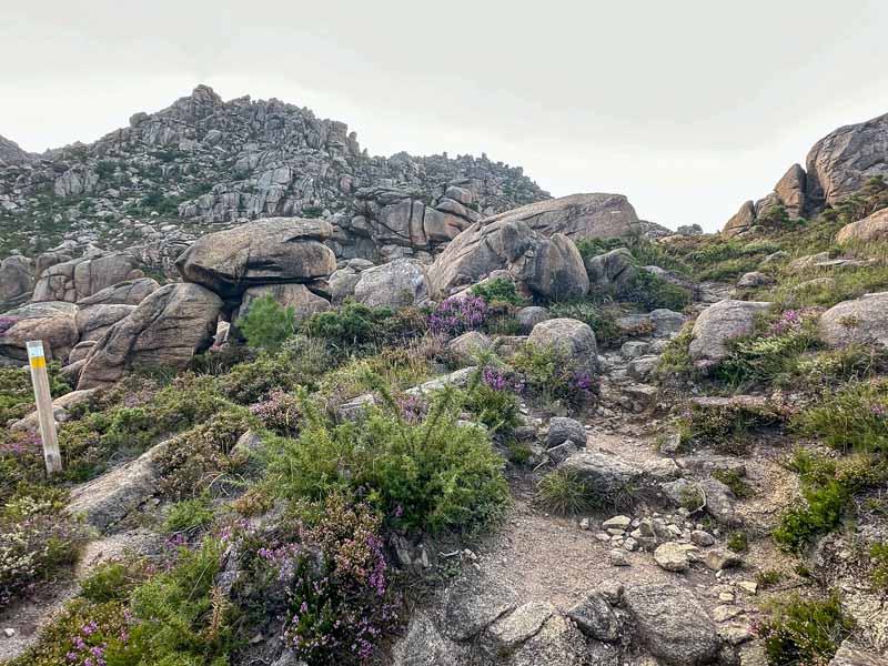
Follow the route behind the church. The stone path immediately begins its ascent. One thing that is special here is all the unique rock formations. There really is a noticeable shift in energy and it’s easy to see why this mountain was such a significant spot to the early pagan tribes.
The path does have yellow and white blazes, so make sure to keep your eyes peeled. There are also green and white signboards. Remember, the goal is the top of the craggy mountain, so avoid following some of the goatlike paths that lead to the sea.
Continue on the uphill path past many of the stone figures and structures. As the route ascends you’ll start to get views of one of the most impressive beaches in Galicia, Praia de Carnota.
As the trail begins to flatten you’ll soon notice the giant Mine Warrior or Xigante da Mina.
🥾 O Pindo Trailhead – Giant | Distance: 2.2 Miles | Duration: +/ 1 hour 45 minutes
Giant to A Moa (Summit)


Continue on the path and make sure to follow the Ruta 2 signboard towards Pindo. The trail gets steeper as it ascends.
Be mindful that the summit of A Moa is kind of hard to find and the trail is not well marked. Some sort of offline map is essential. The signboard says A Moa when you reach the top, but you kind of have to scale the rocks since the trail isn’t clear.
⁉️ The steep cliffs have sharp drop-offs so try and follow a more central route to reach the summit. I had to check in with an offline map.
On the day I visited the winds were extremely strong. If the winds are too strong do not risk climbing to the top of the exposed summit. There is no shelter or protection and the wind gusts can be extremely powerful.
The summit is marked with a concrete pole.
🥾 Giant – A Moa | Distance: .6 miles | Duration: +/ – 40 minutes
A Moa

The views of the Death Coast from A Moa are impressive. There are 360° views of many of the beaches, villages, and mountains. Of course, you’re at the tallest point of all of the nearby mountains at 2,057 ft.
To my surprise, on the day I hiked, I saw a local at the top who showed me some of the ancient crosses that were carved in the stones by the Celtic communities. If he hadn’t been there I might have missed them!
Again the Moas are said to resemble human moral teeth and originate from erosion, however, they kind of reminded me of the Inca astrology stones that I saw at so many sacred sites in Peru.
If you look closely there are supposed remains of an ancient city, yet it was so windy it was hard for me to explore too far away from the central summit area.
It can be hard to find the trail down from A Moa, always use caution. I like to record my routes with my Apple Watch so I can follow my actual trail back down.
If looking for a good place to rest there is a small rest area with picnic tables and no shade near the base of the summit.
The 3 Options to Hike Down Monte Pindo

There are two main ways to hike down Monte Pindo.
Out & Back Trail to Pindo | Recommended
The best way to get down to Monte Pindo is to take the same trail back to Pindo. Simply follow the same route back to the church in O Pindo.
🥾 O Pindo – A Moa Round Trip | Distance: 5.6 Miles (9 Km) | Duration: +/- 4 hours
Follow the Trail to Fieiro and Ézaro | Also Recommended


Additionally, if you started in Pindo it’s possible to come down A Moa and walk in the direction of O Fieiro. I stopped at the rest area had lunch and continued to O Fiero. There is a wooden signboard that marks 3.4 Km to O Fieiro, which was pretty accurate.
This section of the trail is wider and less steep. Another bonus is the trail is less rocky as it inches closer to Fieiro. There is even a section that includes a wide grassy path.
As the trail approaches Fieiro, you can see those distant views of the Santa Uxía Reservoir of the Xallas River. The trail ends at the O Fieiro parking lot next to a park. There is no public transportation here, so you must arrange a taxi for pick-up prior to arrival or walk along the road to Ezaro.
🥾 A Moa – O Fieiro | Distance: 2.1 Miles (3.4 Km) | Duration: +/- 45 minutes

Once in the parking lot, continue on the road over the dam. For safety, always walk on the left side of the road. Continue on the road and stop to savor the views at the observation deck of Mirador de Ezaro. After that, it’s less than a 30-minute walk downhill on the road to the path to the Ezaro waterfall.
🥾 O Fieiro – Ezaro Waterfall | Distance: 3.1 Miles (5 Km) | Duration: +/- 1 hour 15 minutes
The Cascada de Ezaro is free to visit and makes a lovely addition to the Monte Pindo hike. The Xallas River flows into the Ocean in Ezaro. Stay and enjoy the falls or relax in the little plaza near the park by the Hydroelectric station.
Follow the scenic road along the Xallas River to arrive in Ézaro. Once in the village, find a sandy beach, plenty of cafes, and a bus stop. The buses will be a little behind the departure time in O Pindo.
🥾 O Pindo – A Moa -O Fieiro – Ezaro Waterfall | Total Distance: 8.3 Miles (13.4 Km) | Duration: +/- 6 hours

Follow the Loop Trail | NOT Recommended
This is the route I actually hiked for Monte Pindo and I do not recommend it. It follows the same trails from O Pindo to O Fieiro, but once at the O Fieiro parking lot, you’ll have to find a stone bridge named “Peñafil.” It took me two different trails until I finally found it as it was completely covered in overgrowth.
This section of trail lacks signage, requires some bushwhacking, and is very intrepid. As an experienced hiker, I got lost a few times, couldn’t find the trail, wandered “off path” and overall struggled. I almost drained my entire spare battery pack because I needed to keep my phone on and open to an offline map the entire time. That’s how unclear the route way.
I definitely felt the power of the mountain and saw no one at all on this trail. My legs were also pretty scratched up and bleeding from the overgrowth.
The trail was meant to loop back to the opposite side of A Moa. Even as I approached the A Moa signboard for Pindo, I saw that many sections of the official signage had been completely removed.
I walked this trail in June, so maybe they hadn’t done the maintenance, but it seems they are encouraging hikers to not walk this route and let it overgrown. I’ve included my trekking stats below.
🥾 Monte Pindo Loop Trail | Total Distance: 11 Miles (17.7 Km) | Duration: +/- 7.5 hours
I do not recommend the entire Loop Trail of Monte Pindo, even for experienced hikers
Tips for Visiting & Hiking Monte Pindo

Here are a few tips for hiking to Monte Pindo, one of Galicia’s most sacred mountains.
Be Mindful of the Weather
The weather can change in an instant in Galicia, especially along the Ocean. The wind can gust at the summit and be extremely dangerous. Do not visit the summit during extreme wind gusts.
Also, be mindful that there is no shade coverage along the route. During the summer months, avoid hiking in the afternoon heat.
I wouldn’t recommend hiking in steady rain, as the stones and rocks can become slippery and loosen.
Carry Enough Water
I carried 1.5 L and wish I had more. There is no place to fill up water bottles on the hiking trail. If coming from O Pindo, there is a water fountain located in the small park behind the church.
Do I Need a Guide to Hike Monte Pindo?
Monte Pindo can be hiked independently, as the main trails between O Pindo and O Fieiro are well-marked. One of the hardest parts of the trek is the terrain. The trail is rocky so it’s hard on your ankles and knees. Walking sticks can help with balance and also take the direct impact off of the knees.
Another challenge is the ascent. The hike from O Pindo to A Moa ascends a little over 2,000 feet.
Do not attempt rock climbing unless you are with a professional and have the proper gear.
Can I Start the Monte Pindo Hike from Fieiro?
Yes! The Monte Pindo hike can start from O Fieiro. Be mindful that you will need a car or organize a taxi to begin in Fieiro. There is a parking lot and a signboard.
The trail difficulty from O Fieiro to Monte Pindo is easier as the trail is wider and less steep. Follow the same trail back to O Fieiro or take the steep path down to O Pindo.
What to Do After Hiking Monte Pindo

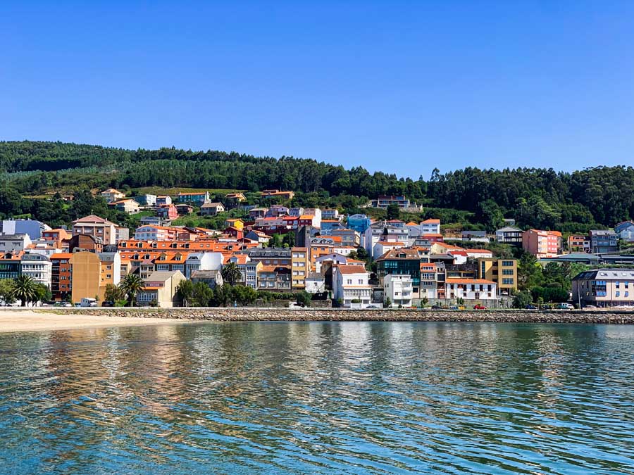
O Pindo has a spectacular beach. There are no bars or cafes on the beach, but it offers stellar views of Monte Pindo. There’s also a small standing ruin of an old lighthouse.
Sol e Mar is a welcoming bar that serves drinks and tapas. Head inside to order and enjoy your refreshments on the terrace with sea views. During lunch and dinner, they also have a full menu.
In the next village of Ézaro, the Cascada de Ezaro is worth a visit!
☛ Read Next | Praia de Area Maior a Worthwhile Beach on the Costa da Morte
Additionally, the buses from O Pindo head in the direction of Santiago de Compostela. Don’t miss these pilgrim-inspired best things to do in Santiago de Compostela.
How to Return to Cee
After hiking Monte Pindo, you’ll need to return to Cee or your accommodation on the Death Coast. This is the bus schedule from O Pindo in the direction of Cee.
As these buses are coming from Santiago de Compostela, make sure to arrive at the bus stop at least 15 minutes and wait at least 15 minutes. My bus was almost 20 minutes late.
Remember, the bus schedules change with the season, so always check the most up-to-date schedules online.
| Departure Time (O Pindo) | Schedule |
| 7:34 | Monday – Friday |
| 10:33 | Daily |
| 12:21 | Daily |
| 14:20 | Saturday & Sunday |
| 15:03 | Monday-Friday |
| 17:40 | Monday – Saturday |
| 19:23 | Monday-Friday |
| 20:33 | Monday – Saturday |
| 20:35 | Saturday & Sunday |
☛ More Places to Visit on the Death Coast | Muxia a Special Fishing Village in Galicia
Conclusion | Hiking the Mystical Monte Pindo
This is the ultimate guide on how to hike the sacred mountain of Monte Pindo in Galicia Spain. This jagged mountain is home to legends and myths and makes for an adventurous day hike on the Death Coast of Spain.
This hiking guide includes a map, how to reach the trailhead, and the varied routes of Monte Pindo.
At the top of A Moa, expect to be wowed by the unique rock formations and the incredible coastal views of the underrated Costa da Morte.
Hiking the Mystical Monte Pindo is a highlight of visiting Galicia Spain.
Pack This Post for Later! Pin It!


Disclaimer: There’s a chance this post contains affiliate links, and I receive a small (but grateful) portion of the sale. There’s no extra cost to you, and I only promote things that I use and love.